Balcón de Europa
The promontory at the heart of town projects into the Mediterranean like a small pier of rock, a sharp point on the coastline that gives the map its focal centre.
მინიმალისტური რუკის პოსტერი · ესპანეთი
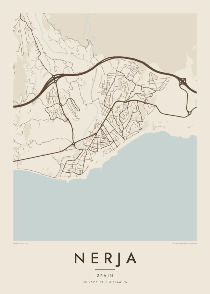
36.7528° N / 3.8744° W
A cliff-top town on a scalloped coastline, cut by ravines and anchored by the Balcón de Europa promontory


ერთი ქალაქი, ხუთი განწყობა
შეეხეთ სტილს, რომ ნახოთ კედელზე. ყველა სტილი ერთი ფასის ღირს — ბეჭდური, ჩარჩოში ან HD ფაილების სახით.
 რეალური პიქსელები · 24 × 36″ ბეჭდვის ფაილი
ბეჭდვის სიმკვეთრე
ეს არის რეალური ბეჭდვის ფაილის 100% ზომის ნაწყვეტი. ყველა პოსტერი — ბეჭდური, ჩარჩოში ან გადმოწერილი — მზადდება ჩვენს სერვერებზე 300 DPI ხარისხით, 7,200 × 10,800 პიქსელამდე, ისე რომ ყველაზე წვრილი ხაზებიც კი მკვეთრი რჩება 24 × 36″ ზომის ბეჭდვისას.
კედელზე


რუკა
Nerja sits at the eastern end of the Málaga coast, where the Sierra Almijara drops steeply toward the Mediterranean. The town occupies a low plateau above the sea, and on a map its edge is anything but straight: small coves, rocky points and beaches alternate along the shore, each tucked between cliffs. Behind the town the mountains close in, leaving a narrow strip for streets and terraces.
At the centre of that coastline is the Balcón de Europa, a promontory that juts into the sea from the old town and forms the most recognisable point on any map of Nerja. Around it the historic streets are short and irregular. East of the centre, Burriana beach traces a long curve, and beyond it the river Chíllar cuts its valley down from the sierra.
Nerja is widely known for its caves, a vast cavern system discovered in 1959 just east of town near the village of Maro, now among the most visited sites in Andalusia. A Nerja map poster brings together the elements that make the place distinct from above: the jagged shore, the promontory, the ravines running to the sea and the mountain wall that frames it all.
The promontory at the heart of town projects into the Mediterranean like a small pier of rock, a sharp point on the coastline that gives the map its focal centre.
Between cliffs, a series of beaches and small coves gives the shoreline a scalloped outline, with Burriana forming the longest and most open curve east of the old town.
The Chíllar descends from the Sierra Almijara along the eastern side of town, its narrow valley tracing a line from the mountains down to the sea.
შექმენით თქვენებური
დაამატეთ თარიღი, სახელი ან თქვენი ფრაზა, შეცვალეთ სტილი, ზომა ან ორიენტაცია.
უფასო გადახედვა არის დაბალი გარჩევადობის და ვოტერმარკით. ბეჭდური და HD ფაილები მზადდება 300 DPI ხარისხით, 7,200 × 10,800 px-მდე, ვოტერმარკის გარეშე.
რატომ Nerja
Nerja is a place people return to year after year, and many Spaniards first saw it in the television series Verano azul, filmed here in the early 1980s. A map of the town is a way to keep those summers at home, from the promontory to the beach where you always swam.
Add a title and subtitle, perhaps the year you first came or the name of your street, and choose Classic black & white, Noir, Paper, Blueprint or Sand. Sand suits the coastline especially well. Get HD files for $9 or a matte printed poster, framed if you prefer.
შეუკვეთეთ Nerja პოსტერი| ბეჭდვის ზომა | გარჩევადობა | ფაილები |
|---|---|---|
| 30 × 40 cm (11.8 × 15.7″) | 3,543 × 4,724 px | PNG · PDF |
| 29.7 × 42 cm (A3, 11.7 × 16.5″) | 3,508 × 4,961 px | PNG · PDF |
| 42 × 59.4 cm (A2, 16.5 × 23.4″) | 4,961 × 7,016 px | PNG · PDF |
| 45.7 × 61 cm (18 × 24″) | 5,400 × 7,200 px | PNG · PDF |
| 50 × 70 cm (19.7 × 27.6″) | 5,906 × 8,268 px | PNG · PDF |
| 61 × 91.4 cm (24 × 36″) | 7,200 × 10,800 px | PNG · PDF |
შედარებისთვის: უფასო პრევიუ 900 px სიგანისაა, წყლის ნიშნით და ეკრანისთვის არის განკუთვნილი. HD ფაილებს თითოეული მიმართულებით 8-ჯერ მეტი გარჩევადობა აქვს და სრული ზომის პოსტერზე სუფთად იბეჭდება.
აირჩიეთ სტილი გვერდის თავში, შემდეგ აირჩიეთ ბეჭდური პოსტერი — ზომა და, სურვილისამებრ, ჩარჩო — ან ციფრული HD ფაილები. გადახდა ერთ ნაბიჯშია, ხოლო თქვენი შეკვეთის გვერდი განახლდება გადახდის დასრულებისთანავე.
ის იბეჭდება პრემიუმ 200 გ/მ² მატ ქაღალდზე, ექვსი ზომიდან ერთ-ერთში, 30 × 40 სმ-დან 24 × 36″-მდე. ბეჭდური პოსტერების ფასი იწყება {printFrom}-დან, მიწოდება უფასოა.
დიახ. აირჩიეთ მასიური ხის ჩარჩო — შავი, თეთრი, ნატურალური მუხის ან მუქი ხის ფერში. ის მოდის ურღვევი მინით და მზადაა ჩამოსაკიდებლად. ჩარჩოიანი პოსტერების ფასი იწყება {framedFrom}-დან, მიწოდება უფასოა.
მიწოდება მთელ მსოფლიოში უფასოა. თითოეული პოსტერი იბეჭდება ჩვენი უახლოესი ბეჭდვის პარტნიორის მიერ 30+ ქვეყანაში და, ჩვეულებრივ, მოდის 3–7 სამუშაო დღეში. სტატუსისა და თრექინგის ნახვა შეგიძლიათ „ჩემი შეკვეთების“ გვერდზე.
გამოგვიგზავნეთ ფოტო მიწოდებიდან 14 დღის განმავლობაში და ჩვენ უფასოდ დაგიბეჭდავთ ხელახლა ან თანხას დაგიბრუნებთ.
დიახ. ამ გვერდის რედაქტორში შეცვალეთ სათაური, ქვესათაური და კოორდინატების ხაზი როგორც გსურთ, და აირჩიეთ სტილი და ზომა. ბეჭდურ, ჩარჩოიან და ციფრულ შეკვეთებში ზუსტად თქვენი დიზაინი გამოიყენება.
$9-ად მიიღებთ 300 DPI PNG და ბეჭდვისთვის მზა PDF ფაილებს ყველა ექვს ზომაში, ვოტერმარკის გარეშე, ნებისმიერ ადგილას დასაბეჭდად. ჯერ არ ხართ დარწმუნებული? ჯერ ჩამოტვირთეთ უფასო ვერსია ვოტერმარკით.
ახლომახლო
