The caldera
The flooded centre of the old volcano forms a broad open space inside the crescent. It is bordered by cliffs that fall steeply into the sea.
მინიმალისტური რუკის პოსტერი · საბერძნეთი
36.4072° N / 25.4209° E
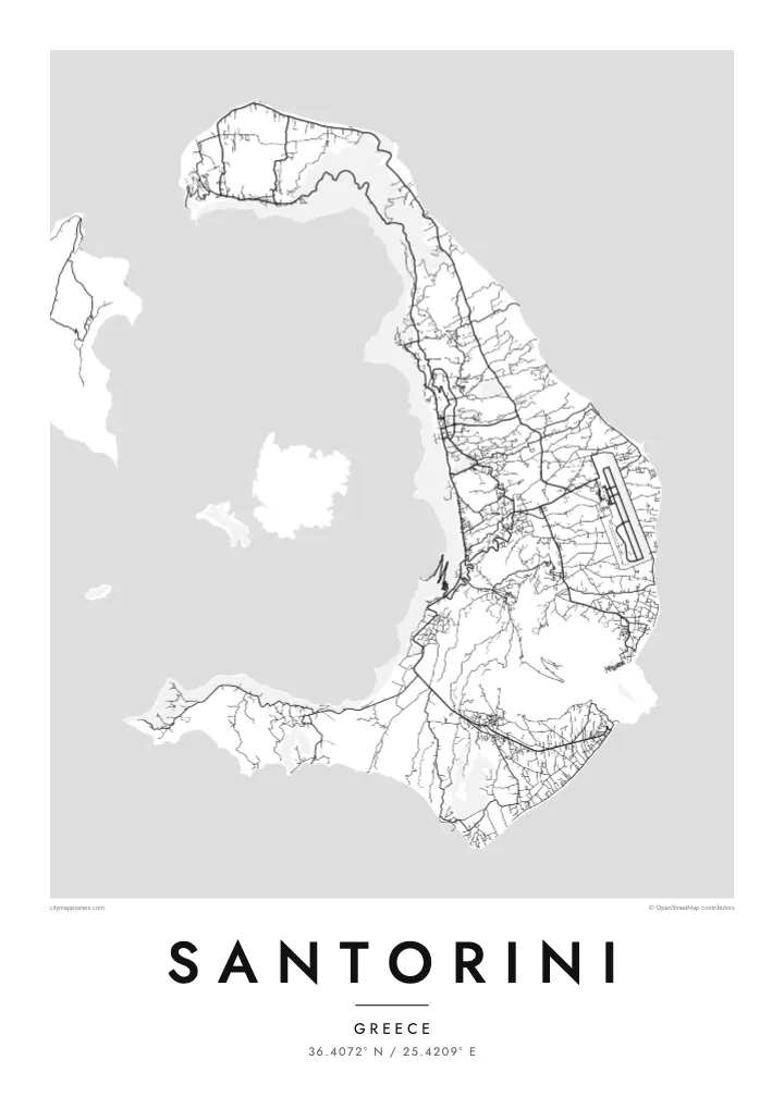
A crescent of land around a flooded volcanic caldera, with a young volcanic island rising in the middle.


ერთი ქალაქი, ხუთი განწყობა
შეეხეთ სტილს, რომ ნახოთ კედელზე. ყველა სტილი ერთი ფასის ღირს — ბეჭდური, ჩარჩოში ან HD ფაილების სახით.
 რეალური პიქსელები · 24 × 36″ ბეჭდვის ფაილი
ბეჭდვის სიმკვეთრე
ეს არის რეალური ბეჭდვის ფაილის 100% ზომის ნაწყვეტი. ყველა პოსტერი — ბეჭდური, ჩარჩოში ან გადმოწერილი — მზადდება ჩვენს სერვერებზე 300 DPI ხარისხით, 7,200 × 10,800 პიქსელამდე, ისე რომ ყველაზე წვრილი ხაზებიც კი მკვეთრი რჩება 24 × 36″ ზომის ბეჭდვისას.
კედელზე


რუკა
Santorini is the remaining rim of a volcano. From above, the main island forms a crescent that wraps around a large, flooded caldera, with Therasia and a smaller islet completing the ring to the west. In the centre of the water sits Nea Kameni, a dark, young volcanic island that formed in eruptions over the past few centuries.
The inner edge of the crescent is a steep cliff, and the island's best-known villages cling to its top. Fira, the main town, and Oia at the northern tip are dense clusters of lanes and stairways overlooking the caldera. The outer side slopes gently to the east and south, towards farmland, vineyards and long dark beaches. The airport and most of the roads are on this side.
A Santorini map poster captures one of the most dramatic outlines in the Mediterranean. The Bronze Age eruption that shaped much of the caldera buried the settlement at Akrotiri, on the southern tip, and preserved its buildings and wall paintings under ash. On the map, the curve of the island and the empty water inside it make a striking composition in black and white.
The flooded centre of the old volcano forms a broad open space inside the crescent. It is bordered by cliffs that fall steeply into the sea.
A young volcanic island in the middle of the caldera, formed by eruptions over recent centuries. It appears as a dark, compact shape in the empty water.
Tight networks of lanes and steps run along the rim of the cliff. From above they look like fine lines tracing the inner edge of the island.
შექმენით თქვენებური
დაამატეთ თარიღი, სახელი ან თქვენი ფრაზა, შეცვალეთ სტილი, ზომა ან ორიენტაცია.
უფასო გადახედვა არის დაბალი გარჩევადობის და ვოტერმარკით. ბეჭდური და HD ფაილები მზადდება 300 DPI ხარისხით, 7,200 × 10,800 px-მდე, ვოტერმარკის გარეშე.
რატომ Santorini
Santorini is where many people get married, spend a honeymoon or watch a sunset they still talk about. The crescent and caldera make an image that is instantly recognisable, and a monochrome print keeps it graphic rather than postcard-like.
Add names and a date to the title and subtitle, or set the coordinates to a particular terrace in Oia or Fira. Choose from Classic black & white, Noir, Paper, Blueprint or Sand.
შეუკვეთეთ Santorini პოსტერი| ბეჭდვის ზომა | გარჩევადობა | ფაილები |
|---|---|---|
| 30 × 40 cm11.8 × 15.7″ | 3,543 × 4,724 px | PNG · PDF |
| 29.7 × 42 cm (A3)11.7 × 16.5″ | 3,508 × 4,961 px | PNG · PDF |
| 42 × 59.4 cm (A2)16.5 × 23.4″ | 4,961 × 7,016 px | PNG · PDF |
| 45.7 × 61 cm18 × 24″ | 5,400 × 7,200 px | PNG · PDF |
| 50 × 70 cm19.7 × 27.6″ | 5,906 × 8,268 px | PNG · PDF |
| 61 × 91.4 cm24 × 36″ | 7,200 × 10,800 px | PNG · PDF |
შედარებისთვის: უფასო პრევიუ 900 px სიგანისაა, წყლის ნიშნით და ეკრანისთვის არის განკუთვნილი. HD ფაილებს თითოეული მიმართულებით 8-ჯერ მეტი გარჩევადობა აქვს და სრული ზომის პოსტერზე სუფთად იბეჭდება.
აირჩიეთ სტილი გვერდის თავში, შემდეგ აირჩიეთ ბეჭდური პოსტერი — ზომა და, სურვილისამებრ, ჩარჩო — ან ციფრული HD ფაილები. გადახდა ერთ ნაბიჯშია, ხოლო თქვენი შეკვეთის გვერდი განახლდება გადახდის დასრულებისთანავე.
ის იბეჭდება პრემიუმ 200 გ/მ² მატ ქაღალდზე, ექვსი ზომიდან ერთ-ერთში, 30 × 40 სმ-დან 24 × 36″-მდე. ბეჭდური პოსტერების ფასი იწყება $39-დან, მიწოდება უფასოა.
დიახ. აირჩიეთ მასიური ხის ჩარჩო — შავი, თეთრი, ნატურალური მუხის ან მუქი ხის ფერში. ის მოდის ურღვევი მინით და მზადაა ჩამოსაკიდებლად. ჩარჩოიანი პოსტერების ფასი იწყება $99-დან, მიწოდება უფასოა.
მიწოდება უფასოა 60+ ქვეყანაში. თითოეულ პოსტერს ბეჭდავს ჩვენი ბეჭდვის პარტნიორებიდან ყველაზე ახლოს მყოფი 30+ ქვეყანაში და ჩვეულებრივ ის 3–7 სამუშაო დღეში მოდის. სტატუსსა და თრექინგს გამოიწერთ განყოფილებაში „ჩემი შეკვეთები“. ზოგ ქვეყანაში მიწოდებას 2–5 კვირა სჭირდება, ხოლო იქ, სადაც ჯერ არ ვაწვდით, საიტი გადახდამდე გაცნობებთ.
გამოგვიგზავნეთ ფოტო მიწოდებიდან 14 დღის განმავლობაში და ჩვენ უფასოდ დაგიბეჭდავთ ხელახლა ან თანხას დაგიბრუნებთ.
დიახ. ამ გვერდის რედაქტორში შეცვალეთ სათაური, ქვესათაური და კოორდინატების ხაზი როგორც გსურთ, და აირჩიეთ სტილი და ზომა. ბეჭდურ, ჩარჩოიან და ციფრულ შეკვეთებში ზუსტად თქვენი დიზაინი გამოიყენება.
$9-ად მიიღებთ 300 DPI PNG და ბეჭდვისთვის მზა PDF ფაილებს ყველა ექვს ზომაში, ვოტერმარკის გარეშე, ნებისმიერ ადგილას დასაბეჭდად. ჯერ არ ხართ დარწმუნებული? ჯერ ჩამოტვირთეთ უფასო ვერსია ვოტერმარკით.
ახლომახლო
