Mays Island
A narrow island in the Cedar River holding civic buildings, linked to both banks by bridges. On the poster it appears as a small block of streets floating in the middle of the water.
Минималистік карта постері · Америка Құрама Штаттары
42.0083° N / 91.6441° W
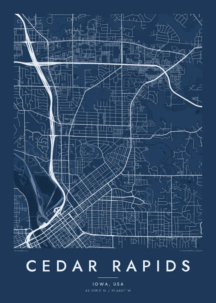
A river city split diagonally by the Cedar, with an island at its centre and four quadrants of numbered streets.



Бір қала, бес көңіл-күй
Стильді басып, оны қабырғада қалай көрінетінін көріңіз. Барлық стильдің бағасы бірдей — басып шығарылған, жақтауланған немесе HD файл түрінде.
 Нақты пиксельдер · 24 × 36″ баспа файлы
Баспада айқын
Бұл нақты баспа файлының 100% кесіндісі. Әрбір постер — басып шығарылған, жақтауланған немесе жүктелген — біздің серверлерде 300 DPI ажыратымдылықпен, 7,200 × 10,800 пикселге дейін өңделеді, сондықтан 24 × 36″ баспада ең кішкентай көшелер де анық көрінеді.
Қабырғада


Карта
From above, Cedar Rapids is organised around the Cedar River, which cuts through the city from northwest to southeast. Streets and avenues are numbered and labelled by quadrant (NE, NW, SE and SW), so the map reads as four grids meeting at the water. Downtown sits on the east bank, and a series of bridges connects it to the west side and to Mays Island in the middle of the channel.
Mays Island is the detail most people remember. Civic buildings stand on it, which makes Cedar Rapids one of very few American cities with its seat of government on a river island. A short walk upstream, the large Quaker Oats plant reflects the city's long connection to grain processing, and on some days the smell of toasted oats drifts across downtown.
A Cedar Rapids map poster shows the whole arrangement at once: the river, the island, Interstate 380 curving through the centre and residential blocks spreading toward the farmland of eastern Iowa. The painter Grant Wood lived and worked here, and his ordered, clean-lined view of the Midwest suits the calm geometry of a black-and-white street map.
A narrow island in the Cedar River holding civic buildings, linked to both banks by bridges. On the poster it appears as a small block of streets floating in the middle of the water.
Numbered streets and avenues divide into NE, NW, SE and SW sections. The result is four slightly offset grids that meet along the river and give the map its structure.
The interstate runs north to south through the city and crosses the river close to downtown. Its long, smooth curves stand out against the square blocks on either side.
Өзіңізге бейімдеңіз
Күнді, есімді не өз жолыңызды қосыңыз, стильді, өлшемді не бағдарды ауыстырыңыз.
Тегін алдын ала қарау төмен ажыратымдылықта және су таңбамен беріледі. Баспалар мен HD файлдар 300 DPI ажыратымдылықпен, 7,200 × 10,800 px-ке дейін, су таңбасыз өңделеді.
Неге Cedar Rapids
Cedar Rapids maps tend to go to people with a long attachment to the city: those who grew up in its quadrants, worked in its plants and offices, or helped rebuild after the 2008 flood. The river and the island make the layout recognisable even without labels.
The title, subtitle and coordinates line can all be personalised, for example with a family name or a date that matters, and the map comes in five styles: Classic black & white, Noir, Paper, Blueprint and Sand. Choose the $9 digital HD files or a printed poster with an optional wooden frame.
Cedar Rapids постерін тапсырыс беру| Басу өлшемі | Ажыратымдылық | Файлдар |
|---|---|---|
| 30 × 40 cm (11.8 × 15.7″) | 3,543 × 4,724 px | PNG · PDF |
| 29.7 × 42 cm (A3, 11.7 × 16.5″) | 3,508 × 4,961 px | PNG · PDF |
| 42 × 59.4 cm (A2, 16.5 × 23.4″) | 4,961 × 7,016 px | PNG · PDF |
| 45.7 × 61 cm (18 × 24″) | 5,400 × 7,200 px | PNG · PDF |
| 50 × 70 cm (19.7 × 27.6″) | 5,906 × 8,268 px | PNG · PDF |
| 61 × 91.4 cm (24 × 36″) | 7,200 × 10,800 px | PNG · PDF |
Салыстыру үшін: тегін нұсқаның ені 900 px, су белгісі бар және экранға арналған. HD файлдардың ажыратымдылығы әр бағытта 8 есеге дейін жоғары және толық постер өлшемінде таза басылады.
Беттің жоғарғы жағынан стильді таңдаңыз, содан кейін Басып шығарылған постерді — өлшемі мен қаласаңыз жақтауын — немесе Цифрлық HD файлдарды таңдаңыз. Төлем бір қадамда жасалады, ал тапсырыс беті төлем өткен бойда жаңарады.
Ол премиум сапалы 200 gsm матталы қағазға алты өлшемнің бірінде — 30 × 40 см-ден 24 × 36″-ке дейін — басып шығарылады. Басып шығарылған постерлердің бағасы $39-дан басталады, жеткізу құны кіреді.
Иә. Қара, ақ, табиғи емен немесе қою түсті ағаштан жасалған қатты жақтауды таңдаңыз. Ол сынбайтын шыныммен келеді және ілуге дайын. Жақтаулы постерлердің бағасы $99-дан басталады, жеткізу құны кіреді.
Жеткізу бүкіл әлем бойынша тегін. Әр постерді 30+ елдегі баспа серіктестерімізден ең жақыны басып шығарады, әдетте 3–7 жұмыс күнінде жетеді. Мәртебесі мен трекингті «Тапсырыстарым» бөлімінен қадағалай аласыз. Кейбір елдерге 2–5 апта кетеді, ал әзірге жеткізбейтін жерлер туралы сайт төлемге дейін хабарлайды.
Жеткізілген күннен бастап 14 күн ішінде бізге фотосурет жіберіңіз, біз оны тегін қайта басып шығарамыз немесе ақшаңызды қайтарамыз.
Иә. Осы беттегі редакторда тақырыпты, тақырыпшаны және координаталар жолын қалауыңызша өзгертіп, стиль мен өлшемді таңдаңыз. Басып шығарылған, жақтаулы және цифрлық тапсырыстардың барлығы дәл сіздің дизайныңызды қолданады.
$9 үшін сіз барлық алты өлшемде 300 DPI PNG және баспаға дайын PDF файлдарын су таңбасыз аласыз, оларды кез келген жерде басып шығаруға болады. Әлі шешім қабылдай алмай тұрсыз ба? Алдымен тегін, су таңбасы бар алдын ала қарауды жүктеп алыңыз.
Жақын маңда
