Suomenlinna sea fortress
Built in the eighteenth century across several linked islands at the harbour entrance, its angular bastions and irregular walls form one of the most distinctive outlines on the whole map.
Минималистік карта постері · Финляндия
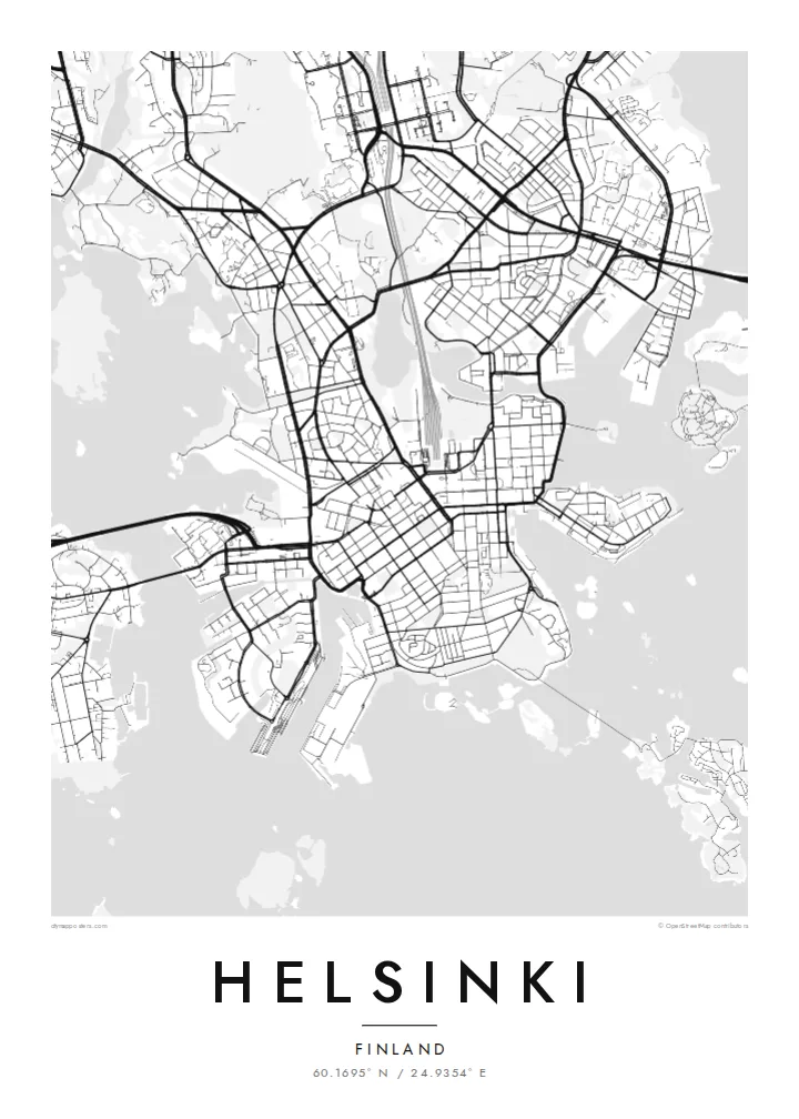
60.1695° N / 24.9354° E
A granite peninsula that breaks into bays and islands, with a compact grid at its tip and sea on three sides


Бір қала, бес көңіл-күй
Стильді басып, оны қабырғада қалай көрінетінін көріңіз. Барлық стильдің бағасы бірдей — басып шығарылған, жақтауланған немесе HD файл түрінде.
 Нақты пиксельдер · 24 × 36″ баспа файлы
Баспада айқын
Бұл нақты баспа файлының 100% кесіндісі. Әрбір постер — басып шығарылған, жақтауланған немесе жүктелген — біздің серверлерде 300 DPI ажыратымдылықпен, 7,200 × 10,800 пикселге дейін өңделеді, сондықтан 24 × 36″ баспада ең кішкентай көшелер де анық көрінеді.
Қабырғада


Карта
Helsinki sits on a peninsula that pushes into the Gulf of Finland, and from above its coastline matters most. The land breaks into coves, headlands and more than three hundred islands, so the city carries on past the point where the streets stop. Inland the pattern loosens into leafy districts and a long strip of forest, the Central Park, which runs north almost unbroken from Töölö Bay towards the city's edge.
The centre is orderly. After Helsinki was named capital in 1812, the architect Carl Ludvig Engel laid out a neoclassical core around Senate Square. The Esplanadi park strip still runs west from the market harbour as straight as a ruler. Around it, blocks of stone apartment buildings form a tight grid that reads cleanly in black and white. Rail yards and the long curve of the harbour break it up.
A Helsinki map poster shows this balance of order and irregularity: a precise centre, a coastline with almost no straight lines, and water in every gap. Offshore, the island fortress of Suomenlinna, a UNESCO World Heritage Site, spreads across a cluster of connected islets at the harbour mouth. Ferries, bridges and causeways join the rest together, and each one leaves a thin line on the page.
Built in the eighteenth century across several linked islands at the harbour entrance, its angular bastions and irregular walls form one of the most distinctive outlines on the whole map.
Senate Square and the Esplanadi park avenue sit just back from the South Harbour. They give the densest streets a clear, symmetrical anchor that stands out at every print size.
A band of forest about ten kilometres long runs north from the inner city. It leaves a wide, pale ribbon between the residential districts on either side.
Өзіңізге бейімдеңіз
Күнді, есімді не өз жолыңызды қосыңыз, стильді, өлшемді не бағдарды ауыстырыңыз.
Тегін алдын ала қарау төмен ажыратымдылықта және су таңбамен беріледі. Баспалар мен HD файлдар 300 DPI ажыратымдылықпен, 7,200 × 10,800 px-ке дейін, су таңбасыз өңделеді.
Неге Helsinki
People hang Helsinki for a flat near Töölö, summers on the islands, or an exchange year that turned into something longer. The map holds all of it at once: the harbour, the grid and the sea. Add a title, a date or a line of coordinates to mark which chapter it belongs to.
The coastline works especially well in Noir, where the water turns dark and the islands look like scattered light, or in Blueprint for a cooler, technical look. Classic black & white, Paper and Sand are available too. Download the HD files for $9 or order a matte print, framed if you like.
Helsinki постерін тапсырыс беру| Басу өлшемі | Ажыратымдылық | Файлдар |
|---|---|---|
| 30 × 40 cm11.8 × 15.7″ | 3,543 × 4,724 px | PNG · PDF |
| 29.7 × 42 cm (A3)11.7 × 16.5″ | 3,508 × 4,961 px | PNG · PDF |
| 42 × 59.4 cm (A2)16.5 × 23.4″ | 4,961 × 7,016 px | PNG · PDF |
| 45.7 × 61 cm18 × 24″ | 5,400 × 7,200 px | PNG · PDF |
| 50 × 70 cm19.7 × 27.6″ | 5,906 × 8,268 px | PNG · PDF |
| 61 × 91.4 cm24 × 36″ | 7,200 × 10,800 px | PNG · PDF |
Салыстыру үшін: тегін нұсқаның ені 900 px, су белгісі бар және экранға арналған. HD файлдардың ажыратымдылығы әр бағытта 8 есеге дейін жоғары және толық постер өлшемінде таза басылады.
Беттің жоғарғы жағынан стильді таңдаңыз, содан кейін Басып шығарылған постерді — өлшемі мен қаласаңыз жақтауын — немесе Цифрлық HD файлдарды таңдаңыз. Төлем бір қадамда жасалады, ал тапсырыс беті төлем өткен бойда жаңарады.
Ол премиум сапалы 200 gsm матталы қағазға алты өлшемнің бірінде — 30 × 40 см-ден 24 × 36″-ке дейін — басып шығарылады. Басып шығарылған постерлердің бағасы $39-дан басталады, жеткізу құны кіреді.
Иә. Қара, ақ, табиғи емен немесе қою түсті ағаштан жасалған қатты жақтауды таңдаңыз. Ол сынбайтын шыныммен келеді және ілуге дайын. Жақтаулы постерлердің бағасы $99-дан басталады, жеткізу құны кіреді.
60+ елге жеткізу тегін. Әр постер 30+ елдегі баспа серіктестеріміздің ең жақынында басылып, әдетте 3–7 жұмыс күнінде жетеді. Күйі мен трекингті «Менің тапсырыстарым» бөлімінен қадағалай аласыз. Кейбір елдерге 2–5 апта кетеді, ал әзірге жеткізбейтін жерлер туралы сайт төлем алдында хабарлайды.
Жеткізілген күннен бастап 14 күн ішінде бізге фотосурет жіберіңіз, біз оны тегін қайта басып шығарамыз немесе ақшаңызды қайтарамыз.
Иә. Осы беттегі редакторда тақырыпты, тақырыпшаны және координаталар жолын қалауыңызша өзгертіп, стиль мен өлшемді таңдаңыз. Басып шығарылған, жақтаулы және цифрлық тапсырыстардың барлығы дәл сіздің дизайныңызды қолданады.
$9 үшін сіз барлық алты өлшемде 300 DPI PNG және баспаға дайын PDF файлдарын су таңбасыз аласыз, оларды кез келген жерде басып шығаруға болады. Әлі шешім қабылдай алмай тұрсыз ба? Алдымен тегін, су таңбасы бар алдын ала қарауды жүктеп алыңыз.
Жақын маңда
