Ming city wall
One of the longest surviving city walls in the world, following ridges and lakeshores for more than twenty kilometres. On the poster it forms an irregular loop around the historic core.
Минималистік карта постері · Қытай
32.0617° N / 118.7778° E
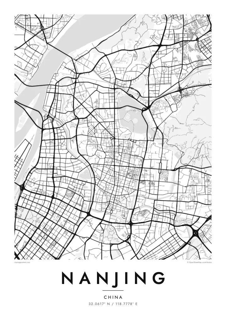
The Yangtze sweeping past a Ming-walled city, with Xuanwu Lake pressed against the wall and Purple Mountain rising east.


Бір қала, бес көңіл-күй
Стильді басып, оны қабырғада қалай көрінетінін көріңіз. Барлық стильдің бағасы бірдей — басып шығарылған, жақтауланған немесе HD файл түрінде.
 Нақты пиксельдер · 24 × 36″ баспа файлы
Баспада айқын
Бұл нақты баспа файлының 100% кесіндісі. Әрбір постер — басып шығарылған, жақтауланған немесе жүктелген — біздің серверлерде 300 DPI ажыратымдылықпен, 7,200 × 10,800 пикселге дейін өңделеді, сондықтан 24 × 36″ баспада ең кішкентай көшелер де анық көрінеді.
Қабырғада


Карта
Nanjing lies on the southern bank of the Yangtze, where the river turns northeast, and the city has faced the water for well over two thousand years. Its most distinctive feature from above is the Ming city wall, built in the fourteenth century and still standing along much of its length. The line bends irregularly around hills and lakes rather than forming a neat rectangle.
Inside and around the wall, the city is full of water. Xuanwu Lake lies just beyond the northern stretch, the Qinhuai River curves through the south past the Confucius Temple district, and moats follow the old fortifications. East of the centre, Purple Mountain carries the Sun Yat-sen Mausoleum and the Ming Xiaoling tomb within a large forested area, which reads as open space on the map.
Nanjing served as the capital of China under several dynasties and governments, which explains its ceremonial avenues and monumental gates. Zhonghua Gate in the south is one of the largest surviving city gates in China. A Nanjing map poster frames the river, the wall and the mountain together, the three features most often cited in explaining why the city was chosen as a capital.
One of the longest surviving city walls in the world, following ridges and lakeshores for more than twenty kilometres. On the poster it forms an irregular loop around the historic core.
The river that loops through southern Nanjing, running both outside and inside the wall, past the Confucius Temple and its old lanes. Its bends define the southern edge of the old city.
The forested mountain east of the walls holds the Sun Yat-sen Mausoleum, the Ming Xiaoling tomb and an observatory. On the map it appears as a large, calm area of paths and slopes.
Өзіңізге бейімдеңіз
Күнді, есімді не өз жолыңызды қосыңыз, стильді, өлшемді не бағдарды ауыстырыңыз.
Тегін алдын ала қарау төмен ажыратымдылықта және су таңбамен беріледі. Баспалар мен HD файлдар 300 DPI ажыратымдылықпен, 7,200 × 10,800 px-ке дейін, су таңбасыз өңделеді.
Неге Nanjing
Nanjing is a city people study in, and many graduates of its universities carry a lasting attachment to its plane-tree avenues and old gates. A map of the walled city is a way of keeping those years in view, long after leaving.
Set your own title and subtitle, perhaps a graduation year, and edit the coordinates line if you like. Choose from five styles; Paper and Sand suit the old wall, Blueprint the river crossings. Order the HD files or a matte print with an optional wooden frame.
Nanjing постерін тапсырыс беру| Басу өлшемі | Ажыратымдылық | Файлдар |
|---|---|---|
| 30 × 40 cm11.8 × 15.7″ | 3,543 × 4,724 px | PNG · PDF |
| 29.7 × 42 cm (A3)11.7 × 16.5″ | 3,508 × 4,961 px | PNG · PDF |
| 42 × 59.4 cm (A2)16.5 × 23.4″ | 4,961 × 7,016 px | PNG · PDF |
| 45.7 × 61 cm18 × 24″ | 5,400 × 7,200 px | PNG · PDF |
| 50 × 70 cm19.7 × 27.6″ | 5,906 × 8,268 px | PNG · PDF |
| 61 × 91.4 cm24 × 36″ | 7,200 × 10,800 px | PNG · PDF |
Салыстыру үшін: тегін нұсқаның ені 900 px, су белгісі бар және экранға арналған. HD файлдардың ажыратымдылығы әр бағытта 8 есеге дейін жоғары және толық постер өлшемінде таза басылады.
Беттің жоғарғы жағынан стильді таңдаңыз, содан кейін Басып шығарылған постерді — өлшемі мен қаласаңыз жақтауын — немесе Цифрлық HD файлдарды таңдаңыз. Төлем бір қадамда жасалады, ал тапсырыс беті төлем өткен бойда жаңарады.
Ол премиум сапалы 200 gsm матталы қағазға алты өлшемнің бірінде — 30 × 40 см-ден 24 × 36″-ке дейін — басып шығарылады. Басып шығарылған постерлердің бағасы $39-дан басталады, жеткізу құны кіреді.
Иә. Қара, ақ, табиғи емен немесе қою түсті ағаштан жасалған қатты жақтауды таңдаңыз. Ол сынбайтын шыныммен келеді және ілуге дайын. Жақтаулы постерлердің бағасы $99-дан басталады, жеткізу құны кіреді.
60+ елге жеткізу тегін. Әр постер 30+ елдегі баспа серіктестеріміздің ең жақынында басылып, әдетте 3–7 жұмыс күнінде жетеді. Күйі мен трекингті «Менің тапсырыстарым» бөлімінен қадағалай аласыз. Кейбір елдерге 2–5 апта кетеді, ал әзірге жеткізбейтін жерлер туралы сайт төлем алдында хабарлайды.
Жеткізілген күннен бастап 14 күн ішінде бізге фотосурет жіберіңіз, біз оны тегін қайта басып шығарамыз немесе ақшаңызды қайтарамыз.
Иә. Осы беттегі редакторда тақырыпты, тақырыпшаны және координаталар жолын қалауыңызша өзгертіп, стиль мен өлшемді таңдаңыз. Басып шығарылған, жақтаулы және цифрлық тапсырыстардың барлығы дәл сіздің дизайныңызды қолданады.
$9 үшін сіз барлық алты өлшемде 300 DPI PNG және баспаға дайын PDF файлдарын су таңбасыз аласыз, оларды кез келген жерде басып шығаруға болады. Әлі шешім қабылдай алмай тұрсыз ба? Алдымен тегін, су таңбасы бар алдын ала қарауды жүктеп алыңыз.
Жақын маңда
