Mays Island
A narrow island in the Cedar River holding civic buildings, linked to both banks by bridges. On the poster it appears as a small block of streets floating in the middle of the water.
Nunap assingata plakatia minimalistiusoq · US
42.0083° N / 91.6441° W
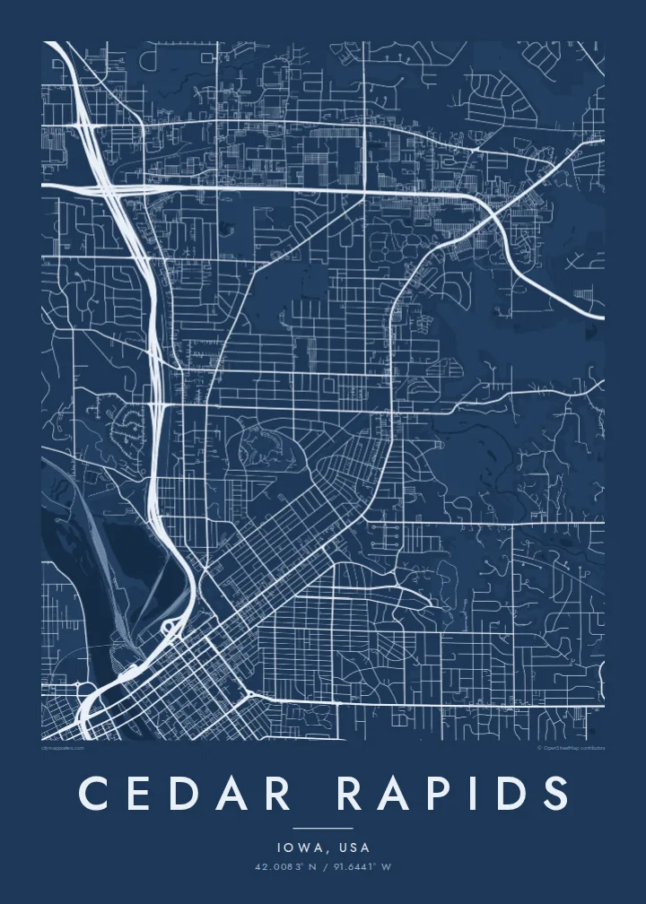
A river city split diagonally by the Cedar, with an island at its centre and four quadrants of numbered streets.



Illoqarfik ataaseq, misigisat tallimat
Stiili toqqaruk illumi qanoq isikkoqarnersoq takuniassallugu. Stiilit tamaasa akiisa assigiipput — naqitat, qaammatitat imaluunniit HD-filit.
 Pikselit tamakkerlugit · 24 × 36″ naqitat filii
Naqitamut erseqqissoq
Tamanna naqitat filiata 100%-ia ilaannaanga. Poster tamaasa — naqitat, qaammatitallu imaluunniit aalajangersimasumik ikkussat — serverivitsinni 300 DPI-mik, 7,200 × 10,800 pikselinnut tikillugu, suliarineqarput, taamaattumik aqquserpiit mikinerpaaqisut 24 × 36″-imi naqitami erseqqissuarlutik takuneqarsinnaapput.
Sarfamiippoq


Nunap assinga
From above, Cedar Rapids is organised around the Cedar River, which cuts through the city from northwest to southeast. Streets and avenues are numbered and labelled by quadrant (NE, NW, SE and SW), so the map reads as four grids meeting at the water. Downtown sits on the east bank, and a series of bridges connects it to the west side and to Mays Island in the middle of the channel.
Mays Island is the detail most people remember. Civic buildings stand on it, which makes Cedar Rapids one of very few American cities with its seat of government on a river island. A short walk upstream, the large Quaker Oats plant reflects the city's long connection to grain processing, and on some days the smell of toasted oats drifts across downtown.
A Cedar Rapids map poster shows the whole arrangement at once: the river, the island, Interstate 380 curving through the centre and residential blocks spreading toward the farmland of eastern Iowa. The painter Grant Wood lived and worked here, and his ordered, clean-lined view of the Midwest suits the calm geometry of a black-and-white street map.
A narrow island in the Cedar River holding civic buildings, linked to both banks by bridges. On the poster it appears as a small block of streets floating in the middle of the water.
Numbered streets and avenues divide into NE, NW, SE and SW sections. The result is four slightly offset grids that meet along the river and give the map its structure.
The interstate runs north to south through the city and crosses the river close to downtown. Its long, smooth curves stand out against the square blocks on either side.
Nammineq ilusilersoruk
Ulloq, ateq imaluunniit oqaaseqaatitit ilanngukkit, ilusaa, angissusaa imaluunniit sammivia allanngortiguk.
Akeqanngitsoq takuniassaq qaffasissuseq appasinnerusoq ilisarnaataqarluni. Naqitat aamma HD filit 300 DPI-mik, 7,200 × 10,800 px-nut tikillugu, ilisarnaataqanngitsumik suliarineqarput.
Sooq Cedar Rapids
Cedar Rapids maps tend to go to people with a long attachment to the city: those who grew up in its quadrants, worked in its plants and offices, or helped rebuild after the 2008 flood. The river and the island make the layout recognisable even without labels.
The title, subtitle and coordinates line can all be personalised, for example with a family name or a date that matters, and the map comes in five styles: Classic black & white, Noir, Paper, Blueprint and Sand. Choose the $9 digital HD files or a printed poster with an optional wooden frame.
Cedar Rapids posteri tunisaqarfigiuk| Naqitap angissusia | Erseqqissusia | Fiilit |
|---|---|---|
| 30 × 40 cm (11.8 × 15.7″) | 3,543 × 4,724 px | PNG · PDF |
| 29.7 × 42 cm (A3, 11.7 × 16.5″) | 3,508 × 4,961 px | PNG · PDF |
| 42 × 59.4 cm (A2, 16.5 × 23.4″) | 4,961 × 7,016 px | PNG · PDF |
| 45.7 × 61 cm (18 × 24″) | 5,400 × 7,200 px | PNG · PDF |
| 50 × 70 cm (19.7 × 27.6″) | 5,906 × 8,268 px | PNG · PDF |
| 61 × 91.4 cm (24 × 36″) | 7,200 × 10,800 px | PNG · PDF |
Sanilliussigaanni takutitsineq akeqanngitsoq 900 px-inik silissuseqarpoq, nalunaaqutaqarpoq skærmimilu takuneqarnissaanut naatsorsuussaalluni. HD-fiilit sammivimmi tamarmi 8-riaammik erseqqinnerusinnaapput plakatitullu angissusilimmi tamarmi kusanartumik naqiterneqarsinnaallutik.
Qupperneq qulaani stiili toqqaruk, taavalu Poster Naqitat toqqarlugu — angissusia, kissaatigigukku qaammatitaaleraluarlutit — imaluunniit Digital HD Filit toqqaruk. Akiliuteqarnissaq ataatsimik pisarpoq, akiliutigineqareerpat tunisassat qupperneraat immiaassaaq.
Naqinneqarpoq assigiinngitsumik pitsaasumik 200 gsm-imik matte-mik paapimi, angissusit arfinillit ilaanni, 30 × 40 cm-miit 24 × 36″-mut. Naqitat posterit $39-miit aallartissapput, assartuineq ilanngullugu.
Aap. Qaammatit qernertumik, qaqortumik, naturimik eegimik imaluunniit qernertumik qisummik pilersorlugu toqqaruk. Igalaaq qisuutinnavianngitsoq ilaalluni tunniunneqarpoq, aammalu illumut qaleriiffigineqarnissamut piareersimavoq. Qaammatitat posterit $99-miit aallartissapput, assartuineq ilanngullugu.
Nassiussineq nuna tamakkerlugu akeqanngilaq. Assitaq tamaat nunani 30+-ni naqiterisartugut ataani qaninnerpaamit naqiterneqartarpoq, ullunilu sulifiusuni 3–7-ni tikittarluni. Pisiat atuuffissaat aamma malinnaaffigineqarsinnaavoq Pisiassanni (My Orders). Nunat ilaanni sapaatit-akunneri 2–5-ni sivisussuseqarpoq, nunanilu suliffissaarutitsinnik nassiussaqarsinnaanngitsuni qiffissap saqqummiunneqartarpoq akiliinnginnermi.
Tikinneranit ullut 14-ni ingerlanngata ammasumik assiliaq nassiutigiuk, naqissaanngitsoq nutaamik naqinniassavarput imaluunniit akiliutit utertissavatit.
Aap. Qupperami editorimi, qulequtaq, qulequtaa ataani allaassutaq aamma sumiiffiup killiffiginera allanngortikkit kissaatigisatit malillugit, stiilillu angissusiallu toqqarlugit. Naqitat, qaammatitat aamma digitalit tunisassat tamarmik ilinnut sanaartorsimasoq atorput.
$9-mik akilerlugu 300 DPI PNG-mik aamma naqinnissamut piareersimasumik PDF-imik, angissusit arfinillit tamaasa, ilisarnaataqanngitsumik, sumiluunniit naqinniarnissamut pisaqassaatit. Suli isumaqanngiluit? Siullermik ilisarnaatilik akeqanngitsoq takuniassaq aallaqqaataani ikkussigit.
Qanittuni
