Central junction
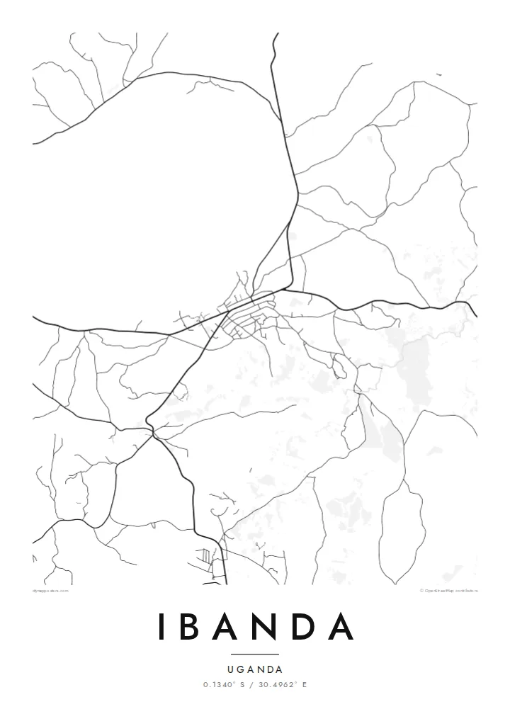
The main roads come together at the town centre, where the street network is densest. Most of the other routes on the poster branch out from this point.
Nunap assingata plakatia minimalistiusoq · UG
0.1340° S / 30.4962° E
A hill town in western Uganda, where roads follow the ridges and farmland fills the valleys between them


Illoqarfik ataaseq, misigisat tallimat
Stiili toqqaruk illumi qanoq isikkoqarnersoq takuniassallugu. Stiilit tamaasa akiisa assigiipput — naqitat, qaammatitat imaluunniit HD-filit.
 Pikselit tamakkerlugit · 24 × 36″ naqitat filii
Naqitamut erseqqissoq
Tamanna naqitat filiata 100%-ia ilaannaanga. Poster tamaasa — naqitat, qaammatitallu imaluunniit aalajangersimasumik ikkussat — serverivitsinni 300 DPI-mik, 7,200 × 10,800 pikselinnut tikillugu, suliarineqarput, taamaattumik aqquserpiit mikinerpaaqisut 24 × 36″-imi naqitami erseqqissuarlutik takuneqarsinnaapput.
Sarfamiippoq


Nunap assinga
Ibanda is in western Uganda, in hilly country north of Mbarara. On a map the town looks loose and organic. There is a small commercial core where the main roads meet, and from there tracks and streets spread out along the ridges and down into the valleys. The land around is broken up by farm plots, so the edge of the built-up area is soft and hard to pin down.
The terrain shapes almost everything. Roads tend to follow contours rather than a grid, and housing gathers along the routes that link the town to nearby trading centres. Between the ridges, the lower ground is mostly cultivated. This region of Uganda is known for bananas and cattle keeping, and the farmland can be seen right up to the outer streets.
An Ibanda map poster shows that relationship between settlement and land. The streets make a fine, branching network, closer together near the centre and thinning out towards the hills. It is not a formal plan, and the pattern it forms looks natural, a little like the veins of a leaf spreading out from one stem.
The main roads come together at the town centre, where the street network is densest. Most of the other routes on the poster branch out from this point.
Many roads run along the tops of the hills and follow the curves of the land. On the map they show up as long, gently bending lines instead of straight segments.
Cultivated land comes right up to the town, so the outer streets break up into scattered tracks. This gives the map a soft, feathered edge.
Nammineq ilusilersoruk
Ulloq, ateq imaluunniit oqaaseqaatitit ilanngukkit, ilusaa, angissusaa imaluunniit sammivia allanngortiguk.
Akeqanngitsoq takuniassaq qaffasissuseq appasinnerusoq ilisarnaataqarluni. Naqitat aamma HD filit 300 DPI-mik, 7,200 × 10,800 px-nut tikillugu, ilisarnaataqanngitsumik suliarineqarput.
Sooq Ibanda
An Ibanda map is a personal thing to own. It suits someone who grew up there, has family in the hills around the town or once worked in western Uganda and wants a quiet reminder of the place on the wall.
You can set the title, subtitle and coordinates line yourself, and pick one of five styles: Classic black and white, Noir, Paper, Blueprint or Sand. There is a free watermarked preview. Full HD files cost $9, and printed posters are shipped from partners in more than 30 countries.
Ibanda posteri tunisaqarfigiuk| Naqitap angissusia | Erseqqissusia | Fiilit |
|---|---|---|
| 30 × 40 cm (11.8 × 15.7″) | 3,543 × 4,724 px | PNG · PDF |
| 29.7 × 42 cm (A3, 11.7 × 16.5″) | 3,508 × 4,961 px | PNG · PDF |
| 42 × 59.4 cm (A2, 16.5 × 23.4″) | 4,961 × 7,016 px | PNG · PDF |
| 45.7 × 61 cm (18 × 24″) | 5,400 × 7,200 px | PNG · PDF |
| 50 × 70 cm (19.7 × 27.6″) | 5,906 × 8,268 px | PNG · PDF |
| 61 × 91.4 cm (24 × 36″) | 7,200 × 10,800 px | PNG · PDF |
Sanilliussigaanni takutitsineq akeqanngitsoq 900 px-inik silissuseqarpoq, nalunaaqutaqarpoq skærmimilu takuneqarnissaanut naatsorsuussaalluni. HD-fiilit sammivimmi tamarmi 8-riaammik erseqqinnerusinnaapput plakatitullu angissusilimmi tamarmi kusanartumik naqiterneqarsinnaallutik.
Qupperneq qulaani stiili toqqaruk, taavalu Poster Naqitat toqqarlugu — angissusia, kissaatigigukku qaammatitaaleraluarlutit — imaluunniit Digital HD Filit toqqaruk. Akiliuteqarnissaq ataatsimik pisarpoq, akiliutigineqareerpat tunisassat qupperneraat immiaassaaq.
Naqinneqarpoq assigiinngitsumik pitsaasumik 200 gsm-imik matte-mik paapimi, angissusit arfinillit ilaanni, 30 × 40 cm-miit 24 × 36″-mut. Naqitat posterit {printFrom}-miit aallartissapput, assartuineq ilanngullugu.
Aap. Qaammatit qernertumik, qaqortumik, naturimik eegimik imaluunniit qernertumik qisummik pilersorlugu toqqaruk. Igalaaq qisuutinnavianngitsoq ilaalluni tunniunneqarpoq, aammalu illumut qaleriiffigineqarnissamut piareersimavoq. Qaammatitat posterit {framedFrom}-miit aallartissapput, assartuineq ilanngullugu.
Assartuineq silarsuup tamakkerlugu akeqanngilaq. Poster tamaasa nunani 30+-mi suleqatigisatta naqitat naammattukkaanniit naqinneqarput, pisarialu ullormut 3-7-ni sulinerni tikittarpoq. Sumut killiffigisoq Tunisassakka ataani malinnaaffigisinnaavat.
Tikinneranit ullut 14-ni ingerlanngata ammasumik assiliaq nassiutigiuk, naqissaanngitsoq nutaamik naqinniassavarput imaluunniit akiliutit utertissavatit.
Aap. Qupperami editorimi, qulequtaq, qulequtaa ataani allaassutaq aamma sumiiffiup killiffiginera allanngortikkit kissaatigisatit malillugit, stiilillu angissusiallu toqqarlugit. Naqitat, qaammatitat aamma digitalit tunisassat tamarmik ilinnut sanaartorsimasoq atorput.
$9-mik akilerlugu 300 DPI PNG-mik aamma naqinnissamut piareersimasumik PDF-imik, angissusit arfinillit tamaasa, ilisarnaataqanngitsumik, sumiluunniit naqinniarnissamut pisaqassaatit. Suli isumaqanngiluit? Siullermik ilisarnaatilik akeqanngitsoq takuniassaq aallaqqaataani ikkussigit.
Qanittuni
