Northern settlements
Brades, Little Bay and the surrounding villages gather most of the island's roads in the north, where winding lanes follow the ridges and valleys of the Silver and Centre Hills.
Nunap assingata plakatia minimalistiusoq · GB
16.7493° N / 62.1930° W
A small, pear-shaped Caribbean island whose green northern hills hold the towns while the volcanic south lies closed.


Illoqarfik ataaseq, misigisat tallimat
Stiili toqqaruk illumi qanoq isikkoqarnersoq takuniassallugu. Stiilit tamaasa akiisa assigiipput — naqitat, qaammatitat imaluunniit HD-filit.
 Pikselit tamakkerlugit · 24 × 36″ naqitat filii
Naqitamut erseqqissoq
Tamanna naqitat filiata 100%-ia ilaannaanga. Poster tamaasa — naqitat, qaammatitallu imaluunniit aalajangersimasumik ikkussat — serverivitsinni 300 DPI-mik, 7,200 × 10,800 pikselinnut tikillugu, suliarineqarput, taamaattumik aqquserpiit mikinerpaaqisut 24 × 36″-imi naqitami erseqqissuarlutik takuneqarsinnaapput.
Sarfamiippoq


Nunap assinga
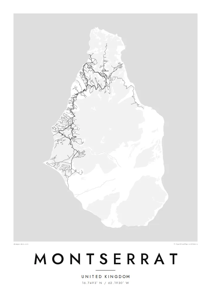
Montserrat is a British Overseas Territory in the Leeward Islands, around sixteen kilometres from north to south. Its shape narrows toward the north, and three groups of hills run down its length: the Silver Hills at the northern tip, the forested Centre Hills in the middle and the Soufrière Hills in the south. It has long been called the Emerald Isle of the Caribbean, partly for its Irish heritage.
Since 1995 the Soufrière Hills volcano has reshaped the island. Eruptions buried the former capital, Plymouth, and much of the south became an exclusion zone. A Montserrat map poster therefore shows an unusual pattern: roads and villages concentrated in the north, around Brades and Little Bay, and a southern half where the streets of the abandoned capital sit cut off from the rest of the network.
Life on the island moved north after the eruptions, and a new airport, new housing and a small port were built there. The volcano is still monitored closely, and the landscape around it continues to change with each period of activity. The result on paper is a map that records both an island and a recent turn in its history.
Brades, Little Bay and the surrounding villages gather most of the island's roads in the north, where winding lanes follow the ridges and valleys of the Silver and Centre Hills.
The volcano dominates the southern half, its slopes left largely without roads. On the poster this area reads as open ground, a clear graphic contrast with the settled north.
The former capital on the southwest coast was abandoned after the 1997 eruptions. Its street pattern still shows on the map, isolated inside the exclusion zone.
Nammineq ilusilersoruk
Ulloq, ateq imaluunniit oqaaseqaatitit ilanngukkit, ilusaa, angissusaa imaluunniit sammivia allanngortiguk.
Akeqanngitsoq takuniassaq qaffasissuseq appasinnerusoq ilisarnaataqarluni. Naqitat aamma HD filit 300 DPI-mik, 7,200 × 10,800 px-nut tikillugu, ilisarnaataqanngitsumik suliarineqarput.
Sooq Montserrat
People with family ties to Montserrat, and those who knew it before 1995, often want a map that shows the whole island rather than only its settled part. The compact outline fits comfortably on any of the print sizes and keeps its detail.
The title, subtitle and coordinates line can all be changed, so the poster might carry a family village or a year that matters. Pick one of five styles, Classic, Noir, Paper, Blueprint or Sand, then download 300 DPI files for $9 or order a printed poster with an optional wooden frame.
Montserrat posteri tunisaqarfigiuk| Naqitap angissusia | Erseqqissusia | Fiilit |
|---|---|---|
| 30 × 40 cm11.8 × 15.7″ | 3,543 × 4,724 px | PNG · PDF |
| 29.7 × 42 cm (A3)11.7 × 16.5″ | 3,508 × 4,961 px | PNG · PDF |
| 42 × 59.4 cm (A2)16.5 × 23.4″ | 4,961 × 7,016 px | PNG · PDF |
| 45.7 × 61 cm18 × 24″ | 5,400 × 7,200 px | PNG · PDF |
| 50 × 70 cm19.7 × 27.6″ | 5,906 × 8,268 px | PNG · PDF |
| 61 × 91.4 cm24 × 36″ | 7,200 × 10,800 px | PNG · PDF |
Sanilliussigaanni takutitsineq akeqanngitsoq 900 px-inik silissuseqarpoq, nalunaaqutaqarpoq skærmimilu takuneqarnissaanut naatsorsuussaalluni. HD-fiilit sammivimmi tamarmi 8-riaammik erseqqinnerusinnaapput plakatitullu angissusilimmi tamarmi kusanartumik naqiterneqarsinnaallutik.
Qupperneq qulaani stiili toqqaruk, taavalu Poster Naqitat toqqarlugu — angissusia, kissaatigigukku qaammatitaaleraluarlutit — imaluunniit Digital HD Filit toqqaruk. Akiliuteqarnissaq ataatsimik pisarpoq, akiliutigineqareerpat tunisassat qupperneraat immiaassaaq.
Naqinneqarpoq assigiinngitsumik pitsaasumik 200 gsm-imik matte-mik paapimi, angissusit arfinillit ilaanni, 30 × 40 cm-miit 24 × 36″-mut. Naqitat posterit $39-miit aallartissapput, assartuineq ilanngullugu.
Aap. Qaammatit qernertumik, qaqortumik, naturimik eegimik imaluunniit qernertumik qisummik pilersorlugu toqqaruk. Igalaaq qisuutinnavianngitsoq ilaalluni tunniunneqarpoq, aammalu illumut qaleriiffigineqarnissamut piareersimavoq. Qaammatitat posterit $99-miit aallartissapput, assartuineq ilanngullugu.
Nunani 60+-ni nassiussineq akeqanngilaq. Posteri tamaasa nunani 30+-ni naqitsiviit ilaanni qanittoq naqitsivigaa, ullunillu 3–7-ni sulisarfiusuni tikittarpoq. Pisinnaaneq aamma malinnaaffigineq Pisiatta atorlugit malinnaaffigisinnaavat. Nunat ilaanni sapaatit-akunneri 2–5 atorneqartarput, nunanilu suliffissanut suli nassiussinngisatsinni, akiliinnginnermi nittartakkap oqaluuttarpaatit.
Tikinneranit ullut 14-ni ingerlanngata ammasumik assiliaq nassiutigiuk, naqissaanngitsoq nutaamik naqinniassavarput imaluunniit akiliutit utertissavatit.
Aap. Qupperami editorimi, qulequtaq, qulequtaa ataani allaassutaq aamma sumiiffiup killiffiginera allanngortikkit kissaatigisatit malillugit, stiilillu angissusiallu toqqarlugit. Naqitat, qaammatitat aamma digitalit tunisassat tamarmik ilinnut sanaartorsimasoq atorput.
$9-mik akilerlugu 300 DPI PNG-mik aamma naqinnissamut piareersimasumik PDF-imik, angissusit arfinillit tamaasa, ilisarnaataqanngitsumik, sumiluunniit naqinniarnissamut pisaqassaatit. Suli isumaqanngiluit? Siullermik ilisarnaatilik akeqanngitsoq takuniassaq aallaqqaataani ikkussigit.
Qanittuni
