Cap-Vert peninsula
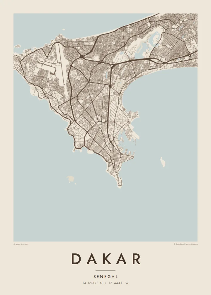
The city fills a hooked peninsula, with ocean on three sides and the mainland to the east, creating a strong, compact silhouette on the page.
ផូស្ទ័រផែនទីបែបសាមញ្ញ · សេណេហ្គាល់
14.6937° N / 17.4441° W
A city at the tip of a peninsula reaching into the Atlantic, the westernmost point of mainland Africa.


ទីក្រុងមួយ អារម្មណ៍ប្រាំ
ចុចលើម៉ូតណាមួយ ដើម្បីមើលវានៅលើជញ្ជាំង។ គ្រប់ម៉ូតទាំងអស់មានតម្លៃដូចគ្នា — មិនថាបោះពុម្ព ធ្វើស៊ុម ឬជាឯកសារ HD។
 ភីកសែលពិតប្រាកដ · ឯកសារបោះពុម្ព 24 × 36″
ច្បាស់ល្អសម្រាប់បោះពុម្ព
នេះជារូបភាពពង្រីក 100% នៃឯកសារបោះពុម្ពពិតប្រាកដ។ ផ្ទាំងគ្រប់សន្លឹក — មិនថាបោះពុម្ព ធ្វើស៊ុម ឬទាញយក — ត្រូវបានបង្កើតនៅលើម៉ាស៊ីនមេរបស់យើងក្នុងគុណភាព 300 DPI រហូតដល់ 7,200 × 10,800 ភីកសែល ដូច្នេះសូម្បីតែផ្លូវតូចបំផុតក៏នៅតែច្បាស់នៅលើក្រដាសបោះពុម្ពទំហំ 24 × 36″។
នៅលើជញ្ជាំង


ផែនទី
Dakar occupies the Cap-Vert peninsula, which pushes out into the Atlantic from the coast of Senegal. At its western end, the Pointe des Almadies is the westernmost point of the African mainland. On a map the city is almost surrounded by water, with the open ocean along the north and west and a sheltered bay and harbour to the south and east.
The historic centre, known as the Plateau, sits on the southern tip, with a regular colonial-era street grid, the port and the main government buildings. From there, the city extends north and west across the peninsula in a mix of planned districts and older neighbourhoods, and coastal roads follow the cliffs and beaches around the edges.
Near the western shore rise the two Mamelles hills, one topped by a lighthouse and the other by the African Renaissance Monument. Offshore lies the small island of Gorée, a UNESCO site associated with the Atlantic slave trade. A Dakar map poster includes that scatter of islands and headlands, which gives the city one of the most recognisable outlines in West Africa.
The city fills a hooked peninsula, with ocean on three sides and the mainland to the east, creating a strong, compact silhouette on the page.
At the southern tip, a tight grid of streets marks the old centre and administrative quarter, set right beside the port and the sheltered harbour.
Small islands sit off the coast, Gorée to the southeast near the harbour and Ngor off the western tip, adding details that frame the peninsula.
ធ្វើឱ្យជារបស់អ្នក
បន្ថែមកាលបរិច្ឆេទ ឈ្មោះ ឬឃ្លាផ្ទាល់ខ្លួន ប្ដូររចនាប័ទ្ម ទំហំ ឬទិសដៅ។
គំរូឥតគិតថ្លៃមានគុណភាពទាប និងមានស្លាកសញ្ញាទឹក។ ការបោះពុម្ព និងឯកសារ HD ត្រូវបានបង្កើតក្នុងគុណភាព 300 DPI រហូតដល់ 7,200 × 10,800 px ដោយគ្មានស្លាកសញ្ញាទឹក។
ហេតុអ្វី Dakar
Dakar is a place people leave and return to, whether for work, family or study, and its peninsula shape is instantly recognisable. A map of the city holds the coastline, the Plateau and the islands in a single calm image.
Make it personal with a title, a subtitle and your own coordinates, perhaps naming a quarter or a date. Five styles are available, including Paper and Sand for warmer rooms, and the HD download covers six print sizes as 300 DPI PNG and PDF files.
កម្មង់ផ្ទាំង Dakar| ទំហំបោះពុម្ព | គុណភាពបង្ហាញ | ឯកសារ |
|---|---|---|
| 30 × 40 cm (11.8 × 15.7″) | 3,543 × 4,724 px | PNG · PDF |
| 29.7 × 42 cm (A3, 11.7 × 16.5″) | 3,508 × 4,961 px | PNG · PDF |
| 42 × 59.4 cm (A2, 16.5 × 23.4″) | 4,961 × 7,016 px | PNG · PDF |
| 45.7 × 61 cm (18 × 24″) | 5,400 × 7,200 px | PNG · PDF |
| 50 × 70 cm (19.7 × 27.6″) | 5,906 × 8,268 px | PNG · PDF |
| 61 × 91.4 cm (24 × 36″) | 7,200 × 10,800 px | PNG · PDF |
ដើម្បីប្រៀបធៀប កំណែមើលជាមុនឥតគិតថ្លៃមានទទឹង 900 px មានស្លាកទឹក និងសម្រាប់មើលលើអេក្រង់។ ឯកសារ HD មានគុណភាពបង្ហាញខ្ពស់ជាងរហូតដល់ 8 ដងគ្រប់ទិស ហើយបោះពុម្ពបានច្បាស់ល្អក្នុងទំហំផូស្ទ័រពេញ។
ជ្រើសរើសម៉ូតនៅផ្នែកខាងលើទំព័រ បន្ទាប់មកជ្រើសរើស ផ្ទាំងបោះពុម្ព — ជ្រើសទំហំ និងស៊ុម (បើចង់) — ឬ ឯកសារឌីជីថល HD។ ការទូទាត់ធ្វើតែមួយជំហាន ហើយទំព័រការកម្មង់របស់អ្នកនឹងធ្វើបច្ចុប្បន្នភាពភ្លាមៗបន្ទាប់ពីទូទាត់ជោគជ័យ។
វាត្រូវបានបោះពុម្ពលើក្រដាសមាត់ខ្នាតខ្ពស់ 200 gsm ប្រភេទស្រអាប់ ក្នុងទំហំចំនួនប្រាំមួយ ចាប់ពី 30 × 40 សម ដល់ 24 × 36″។ ផ្ទាំងបោះពុម្ពមានតម្លៃចាប់ពី $39 រួមការដឹកជញ្ជូន។
បាន។ ជ្រើសរើសស៊ុមឈើសុទ្ធពណ៌ខ្មៅ ស ឈើអុកធម្មជាតិ ឬឈើងងឹត។ វាមកជាមួយកញ្ចក់ធន់នឹងការបែកបាក់ និងអាចព្យួរបានភ្លាមៗ។ ផ្ទាំងមានស៊ុមមានតម្លៃចាប់ពី $99 រួមការដឹកជញ្ជូន។
ការដឹកជញ្ជូនឥតគិតថ្លៃទូទាំងពិភពលោក។ ប៉ុស្ទ័រនីមួយៗត្រូវបានបោះពុម្ពដោយដៃគូបោះពុម្ពដែលនៅជិតបំផុតរបស់យើងក្នុងជាង 30 ប្រទេស ហើយជាទូទៅមកដល់ក្នុងរយៈពេល 3–7 ថ្ងៃធ្វើការ។ អ្នកអាចតាមដានស្ថានភាព និងលេខតាមដានក្នុងផ្នែក ការបញ្ជាទិញរបស់ខ្ញុំ។ ប្រទេសមួយចំនួនត្រូវការពេល 2–5 សប្តាហ៍ ហើយប្រសិនបើយើងមិនទាន់ដឹកជញ្ជូនទៅកន្លែងណា គេហទំព័រនឹងប្រាប់អ្នកមុនពេលអ្នកទូទាត់។
ផ្ញើរូបថតមកយើងក្នុងរយៈពេល 14 ថ្ងៃបន្ទាប់ពីទទួលបាន ហើយយើងនឹងបោះពុម្ពជូនថ្មីដោយឥតគិតថ្លៃ ឬសងប្រាក់វិញ។
បាន។ នៅក្នុងកម្មវិធីកែសម្រួលលើទំព័រនេះ អ្នកអាចផ្លាស់ប្តូរចំណងជើង ចំណងជើងរង និងបន្ទាត់កូអរដោនេទៅជាអ្វីក៏បាន រួចជ្រើសរើសម៉ូត និងទំហំ។ ការកម្មង់ទាំងបោះពុម្ព ស៊ុម និងឌីជីថល សុទ្ធតែប្រើប្រាស់រចនាបថពិតប្រាកដតាមអ្នករចនា។
ក្នុងតម្លៃ $9 អ្នកនឹងទទួលបានឯកសារ PNG និង PDF ត្រៀមបោះពុម្ព គុណភាព 300 DPI ក្នុងទំហំទាំងប្រាំមួយ ដោយគ្មានស្លាកសញ្ញាទឹក សម្រាប់បោះពុម្ពនៅគ្រប់ទីកន្លែង។ មិនទាន់ប្រាកដ? ទាញយកគំរូឥតគិតថ្លៃដែលមានស្លាកសញ្ញាទឹកសាកមើលជាមុនសិន។
