Karakoram Highway
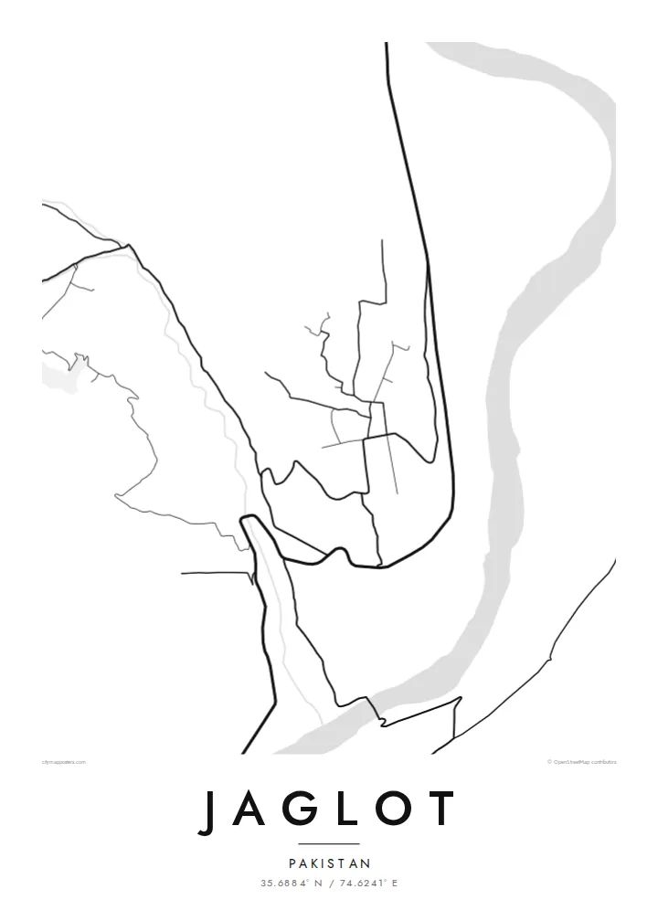
The main road runs the length of the valley and passes directly through Jaglot. On the map, it appears as a long, confident line connecting the region north and south.
ផូស្ទ័រផែនទីបែបសាមញ្ញ · ប៉ាគីស្ថាន
35.6884° N / 74.6241° E
A mountain town on the Karakoram Highway, beside the Indus near the point where three great ranges meet


ទីក្រុងមួយ អារម្មណ៍ប្រាំ
ចុចលើម៉ូតណាមួយ ដើម្បីមើលវានៅលើជញ្ជាំង។ គ្រប់ម៉ូតទាំងអស់មានតម្លៃដូចគ្នា — មិនថាបោះពុម្ព ធ្វើស៊ុម ឬជាឯកសារ HD។
 ភីកសែលពិតប្រាកដ · ឯកសារបោះពុម្ព 24 × 36″
ច្បាស់ល្អសម្រាប់បោះពុម្ព
នេះជារូបភាពពង្រីក 100% នៃឯកសារបោះពុម្ពពិតប្រាកដ។ ផ្ទាំងគ្រប់សន្លឹក — មិនថាបោះពុម្ព ធ្វើស៊ុម ឬទាញយក — ត្រូវបានបង្កើតនៅលើម៉ាស៊ីនមេរបស់យើងក្នុងគុណភាព 300 DPI រហូតដល់ 7,200 × 10,800 ភីកសែល ដូច្នេះសូម្បីតែផ្លូវតូចបំផុតក៏នៅតែច្បាស់នៅលើក្រដាសបោះពុម្ពទំហំ 24 × 36″។
នៅលើជញ្ជាំង


ផែនទី
Jaglot lies in Gilgit-Baltistan, in a deep valley on the Karakoram Highway south of Gilgit. The Indus runs nearby, and the Gilgit River joins it close to the town. On a map, the settlement is a thin strip of streets and fields squeezed between river and mountainside, with the highway threading straight through.
Close to Jaglot, a viewpoint marks the meeting point of three mountain ranges: the Himalaya, the Karakoram and the Hindu Kush. The map shows the effect of this rugged terrain. Flat land exists only along the rivers. Terraced fields and villages sit on alluvial fans below steep slopes, and every road has to follow the valleys.
A Jaglot map poster makes this geography easy to read. The highway, the rivers and the narrow band of settlement form a few strong lines through otherwise empty mountain ground. In black and white, it gives a clear view of one of the most striking valley junctions in northern Pakistan.
The main road runs the length of the valley and passes directly through Jaglot. On the map, it appears as a long, confident line connecting the region north and south.
The Gilgit River meets the Indus close to the town. Their joining channels are the defining water feature of the whole composition.
A nearby viewpoint marks where the Himalaya, Karakoram and Hindu Kush meet. Around it, the map is mostly steep, uninhabited mountain ground.
ធ្វើឱ្យជារបស់អ្នក
បន្ថែមកាលបរិច្ឆេទ ឈ្មោះ ឬឃ្លាផ្ទាល់ខ្លួន ប្ដូររចនាប័ទ្ម ទំហំ ឬទិសដៅ។
គំរូឥតគិតថ្លៃមានគុណភាពទាប និងមានស្លាកសញ្ញាទឹក។ ការបោះពុម្ព និងឯកសារ HD ត្រូវបានបង្កើតក្នុងគុណភាព 300 DPI រហូតដល់ 7,200 × 10,800 px ដោយគ្មានស្លាកសញ្ញាទឹក។
ហេតុអ្វី Jaglot
The poster suits travellers who have driven the Karakoram Highway, climbers heading to the northern peaks and families from Gilgit-Baltistan. Use the personalised title, subtitle and coordinates line to record a journey, a trek date or a home village.
Pick one of five styles: Classic black & white, Noir, Paper, Blueprint or Sand. The digital files are $9 for six sizes, each as a 300 DPI PNG and a print-ready PDF. Printed posters on matte paper ship from partners in more than 30 countries.
កម្មង់ផ្ទាំង Jaglot| ទំហំបោះពុម្ព | គុណភាពបង្ហាញ | ឯកសារ |
|---|---|---|
| 30 × 40 cm11.8 × 15.7″ | 3,543 × 4,724 px | PNG · PDF |
| 29.7 × 42 cm (A3)11.7 × 16.5″ | 3,508 × 4,961 px | PNG · PDF |
| 42 × 59.4 cm (A2)16.5 × 23.4″ | 4,961 × 7,016 px | PNG · PDF |
| 45.7 × 61 cm18 × 24″ | 5,400 × 7,200 px | PNG · PDF |
| 50 × 70 cm19.7 × 27.6″ | 5,906 × 8,268 px | PNG · PDF |
| 61 × 91.4 cm24 × 36″ | 7,200 × 10,800 px | PNG · PDF |
ដើម្បីប្រៀបធៀប កំណែមើលជាមុនឥតគិតថ្លៃមានទទឹង 900 px មានស្លាកទឹក និងសម្រាប់មើលលើអេក្រង់។ ឯកសារ HD មានគុណភាពបង្ហាញខ្ពស់ជាងរហូតដល់ 8 ដងគ្រប់ទិស ហើយបោះពុម្ពបានច្បាស់ល្អក្នុងទំហំផូស្ទ័រពេញ។
ជ្រើសរើសម៉ូតនៅផ្នែកខាងលើទំព័រ បន្ទាប់មកជ្រើសរើស ផ្ទាំងបោះពុម្ព — ជ្រើសទំហំ និងស៊ុម (បើចង់) — ឬ ឯកសារឌីជីថល HD។ ការទូទាត់ធ្វើតែមួយជំហាន ហើយទំព័រការកម្មង់របស់អ្នកនឹងធ្វើបច្ចុប្បន្នភាពភ្លាមៗបន្ទាប់ពីទូទាត់ជោគជ័យ។
វាត្រូវបានបោះពុម្ពលើក្រដាសមាត់ខ្នាតខ្ពស់ 200 gsm ប្រភេទស្រអាប់ ក្នុងទំហំចំនួនប្រាំមួយ ចាប់ពី 30 × 40 សម ដល់ 24 × 36″។ ផ្ទាំងបោះពុម្ពមានតម្លៃចាប់ពី $39 រួមការដឹកជញ្ជូន។
បាន។ ជ្រើសរើសស៊ុមឈើសុទ្ធពណ៌ខ្មៅ ស ឈើអុកធម្មជាតិ ឬឈើងងឹត។ វាមកជាមួយកញ្ចក់ធន់នឹងការបែកបាក់ និងអាចព្យួរបានភ្លាមៗ។ ផ្ទាំងមានស៊ុមមានតម្លៃចាប់ពី $99 រួមការដឹកជញ្ជូន។
ការដឹកជញ្ជូនគឺឥតគិតថ្លៃទៅកាន់ប្រទេសជាង 60។ ប៉ូស្ទ័រនីមួយៗត្រូវបានបោះពុម្ពដោយដៃគូបោះពុម្ពដែលនៅជិតបំផុតក្នុងចំណោមដៃគូរបស់យើងនៅក្នុងប្រទេសជាង 30 ហើយជាធម្មតាមកដល់ក្នុងរយៈពេល 3–7 ថ្ងៃធ្វើការ។ អ្នកអាចតាមដានស្ថានភាព និងលេខតាមដានកញ្ចប់នៅក្នុង «ការបញ្ជាទិញរបស់ខ្ញុំ»។ ប្រទេសមួយចំនួនត្រូវការពេល 2–5 សប្តាហ៍ ហើយប្រសិនបើយើងមិនទាន់ដឹកទៅកាន់ប្រទេសរបស់អ្នក គេហទំព័រនឹងប្រាប់អ្នកមុនពេលអ្នកបង់ប្រាក់។
ផ្ញើរូបថតមកយើងក្នុងរយៈពេល 14 ថ្ងៃបន្ទាប់ពីទទួលបាន ហើយយើងនឹងបោះពុម្ពជូនថ្មីដោយឥតគិតថ្លៃ ឬសងប្រាក់វិញ។
បាន។ នៅក្នុងកម្មវិធីកែសម្រួលលើទំព័រនេះ អ្នកអាចផ្លាស់ប្តូរចំណងជើង ចំណងជើងរង និងបន្ទាត់កូអរដោនេទៅជាអ្វីក៏បាន រួចជ្រើសរើសម៉ូត និងទំហំ។ ការកម្មង់ទាំងបោះពុម្ព ស៊ុម និងឌីជីថល សុទ្ធតែប្រើប្រាស់រចនាបថពិតប្រាកដតាមអ្នករចនា។
ក្នុងតម្លៃ $9 អ្នកនឹងទទួលបានឯកសារ PNG និង PDF ត្រៀមបោះពុម្ព គុណភាព 300 DPI ក្នុងទំហំទាំងប្រាំមួយ ដោយគ្មានស្លាកសញ្ញាទឹក សម្រាប់បោះពុម្ពនៅគ្រប់ទីកន្លែង។ មិនទាន់ប្រាកដ? ទាញយកគំរូឥតគិតថ្លៃដែលមានស្លាកសញ្ញាទឹកសាកមើលជាមុនសិន។
