Prytanée grounds
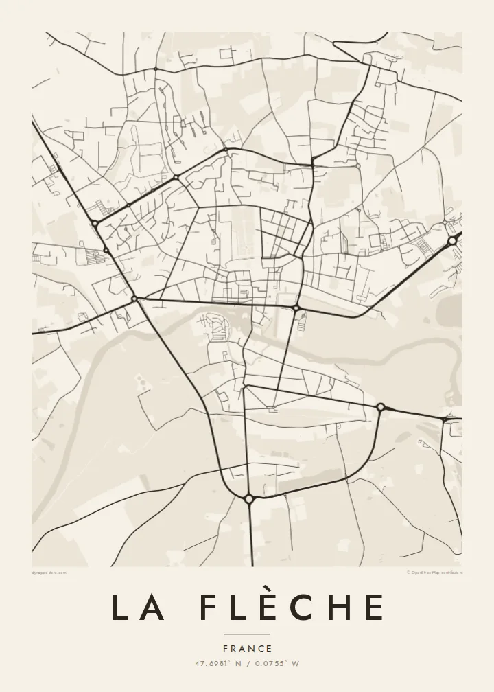
The former Jesuit college founded under Henri IV forms a large rectangular complex of buildings, courtyards and gardens, one of the most distinctive shapes on the map.
ផូស្ទ័រផែនទីបែបសាមញ្ញ · បារាំង
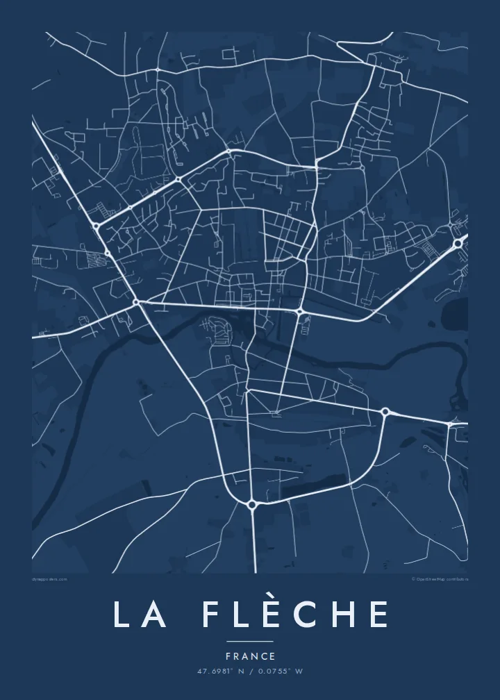
47.6981° N / 0.0755° W
A Loir valley town of broad avenues and river channels, with the long rectangle of the Prytanée at its heart.



ទីក្រុងមួយ អារម្មណ៍ប្រាំ
ចុចលើម៉ូតណាមួយ ដើម្បីមើលវានៅលើជញ្ជាំង។ គ្រប់ម៉ូតទាំងអស់មានតម្លៃដូចគ្នា — មិនថាបោះពុម្ព ធ្វើស៊ុម ឬជាឯកសារ HD។
 ភីកសែលពិតប្រាកដ · ឯកសារបោះពុម្ព 24 × 36″
ច្បាស់ល្អសម្រាប់បោះពុម្ព
នេះជារូបភាពពង្រីក 100% នៃឯកសារបោះពុម្ពពិតប្រាកដ។ ផ្ទាំងគ្រប់សន្លឹក — មិនថាបោះពុម្ព ធ្វើស៊ុម ឬទាញយក — ត្រូវបានបង្កើតនៅលើម៉ាស៊ីនមេរបស់យើងក្នុងគុណភាព 300 DPI រហូតដល់ 7,200 × 10,800 ភីកសែល ដូច្នេះសូម្បីតែផ្លូវតូចបំផុតក៏នៅតែច្បាស់នៅលើក្រដាសបោះពុម្ពទំហំ 24 × 36″។
នៅលើជញ្ជាំង


ផែនទី
La Flèche lies on the Loir in the Sarthe department, between Le Mans and Angers. Its best-known institution is the Prytanée national militaire, which was founded in 1604 as a Jesuit college under Henri IV. René Descartes was one of its pupils. Today it is a military school, and its large grounds still dominate the centre of town.
The town has a legible plan. The Loir and its side channels run past the centre, with a mill, quays and bridges. Straight streets and wide squares show a degree of planning unusual for a town of this size. Beyond the centre, residential districts spread onto the plateau, and the surroundings include woodland and the zoo that the town is also known for.
A La Flèche map poster puts the river and the Prytanée in dialogue. The water curves along one side of the old town, while the school's grounds form a large, calm geometric block. Streets radiate outward to the ring of newer districts, giving the print a balanced, readable structure.
The former Jesuit college founded under Henri IV forms a large rectangular complex of buildings, courtyards and gardens, one of the most distinctive shapes on the map.
The Loir passes the old town in several arms, with bridges and quays, drawing soft curves along the southern side of the centre.
Wide, direct streets and squares link the centre's key points, a clear urban pattern that makes the heart of La Flèche easy to read from above.
ធ្វើឱ្យជារបស់អ្នក
បន្ថែមកាលបរិច្ឆេទ ឈ្មោះ ឬឃ្លាផ្ទាល់ខ្លួន ប្ដូររចនាប័ទ្ម ទំហំ ឬទិសដៅ។
គំរូឥតគិតថ្លៃមានគុណភាពទាប និងមានស្លាកសញ្ញាទឹក។ ការបោះពុម្ព និងឯកសារ HD ត្រូវបានបង្កើតក្នុងគុណភាព 300 DPI រហូតដល់ 7,200 × 10,800 px ដោយគ្មានស្លាកសញ្ញាទឹក។
ហេតុអ្វី La Flèche
La Flèche means a lot to former pupils of the Prytanée, their families, and anyone who knows the Loir valley. The poster captures that combination of river and school in a form that is quiet and easy to recognise.
You can personalise the title, subtitle and coordinates, for instance with a graduating year, and choose one of five styles. Digital files cost $9 in six sizes, including A2 and 50×70 cm. Framed or unframed prints are also available.
កម្មង់ផ្ទាំង La Flèche| ទំហំបោះពុម្ព | គុណភាពបង្ហាញ | ឯកសារ |
|---|---|---|
| 30 × 40 cm (11.8 × 15.7″) | 3,543 × 4,724 px | PNG · PDF |
| 29.7 × 42 cm (A3, 11.7 × 16.5″) | 3,508 × 4,961 px | PNG · PDF |
| 42 × 59.4 cm (A2, 16.5 × 23.4″) | 4,961 × 7,016 px | PNG · PDF |
| 45.7 × 61 cm (18 × 24″) | 5,400 × 7,200 px | PNG · PDF |
| 50 × 70 cm (19.7 × 27.6″) | 5,906 × 8,268 px | PNG · PDF |
| 61 × 91.4 cm (24 × 36″) | 7,200 × 10,800 px | PNG · PDF |
ដើម្បីប្រៀបធៀប កំណែមើលជាមុនឥតគិតថ្លៃមានទទឹង 900 px មានស្លាកទឹក និងសម្រាប់មើលលើអេក្រង់។ ឯកសារ HD មានគុណភាពបង្ហាញខ្ពស់ជាងរហូតដល់ 8 ដងគ្រប់ទិស ហើយបោះពុម្ពបានច្បាស់ល្អក្នុងទំហំផូស្ទ័រពេញ។
ជ្រើសរើសម៉ូតនៅផ្នែកខាងលើទំព័រ បន្ទាប់មកជ្រើសរើស ផ្ទាំងបោះពុម្ព — ជ្រើសទំហំ និងស៊ុម (បើចង់) — ឬ ឯកសារឌីជីថល HD។ ការទូទាត់ធ្វើតែមួយជំហាន ហើយទំព័រការកម្មង់របស់អ្នកនឹងធ្វើបច្ចុប្បន្នភាពភ្លាមៗបន្ទាប់ពីទូទាត់ជោគជ័យ។
វាត្រូវបានបោះពុម្ពលើក្រដាសមាត់ខ្នាតខ្ពស់ 200 gsm ប្រភេទស្រអាប់ ក្នុងទំហំចំនួនប្រាំមួយ ចាប់ពី 30 × 40 សម ដល់ 24 × 36″។ ផ្ទាំងបោះពុម្ពមានតម្លៃចាប់ពី $39 រួមការដឹកជញ្ជូន។
បាន។ ជ្រើសរើសស៊ុមឈើសុទ្ធពណ៌ខ្មៅ ស ឈើអុកធម្មជាតិ ឬឈើងងឹត។ វាមកជាមួយកញ្ចក់ធន់នឹងការបែកបាក់ និងអាចព្យួរបានភ្លាមៗ។ ផ្ទាំងមានស៊ុមមានតម្លៃចាប់ពី $99 រួមការដឹកជញ្ជូន។
ការដឹកជញ្ជូនឥតគិតថ្លៃទូទាំងពិភពលោក។ ប៉ុស្ទ័រនីមួយៗត្រូវបានបោះពុម្ពដោយដៃគូបោះពុម្ពដែលនៅជិតបំផុតរបស់យើងក្នុងជាង 30 ប្រទេស ហើយជាទូទៅមកដល់ក្នុងរយៈពេល 3–7 ថ្ងៃធ្វើការ។ អ្នកអាចតាមដានស្ថានភាព និងលេខតាមដានក្នុងផ្នែក ការបញ្ជាទិញរបស់ខ្ញុំ។ ប្រទេសមួយចំនួនត្រូវការពេល 2–5 សប្តាហ៍ ហើយប្រសិនបើយើងមិនទាន់ដឹកជញ្ជូនទៅកន្លែងណា គេហទំព័រនឹងប្រាប់អ្នកមុនពេលអ្នកទូទាត់។
ផ្ញើរូបថតមកយើងក្នុងរយៈពេល 14 ថ្ងៃបន្ទាប់ពីទទួលបាន ហើយយើងនឹងបោះពុម្ពជូនថ្មីដោយឥតគិតថ្លៃ ឬសងប្រាក់វិញ។
បាន។ នៅក្នុងកម្មវិធីកែសម្រួលលើទំព័រនេះ អ្នកអាចផ្លាស់ប្តូរចំណងជើង ចំណងជើងរង និងបន្ទាត់កូអរដោនេទៅជាអ្វីក៏បាន រួចជ្រើសរើសម៉ូត និងទំហំ។ ការកម្មង់ទាំងបោះពុម្ព ស៊ុម និងឌីជីថល សុទ្ធតែប្រើប្រាស់រចនាបថពិតប្រាកដតាមអ្នករចនា។
ក្នុងតម្លៃ $9 អ្នកនឹងទទួលបានឯកសារ PNG និង PDF ត្រៀមបោះពុម្ព គុណភាព 300 DPI ក្នុងទំហំទាំងប្រាំមួយ ដោយគ្មានស្លាកសញ្ញាទឹក សម្រាប់បោះពុម្ពនៅគ្រប់ទីកន្លែង។ មិនទាន់ប្រាកដ? ទាញយកគំរូឥតគិតថ្លៃដែលមានស្លាកសញ្ញាទឹកសាកមើលជាមុនសិន។
