Kitakami River
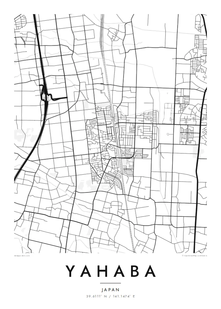
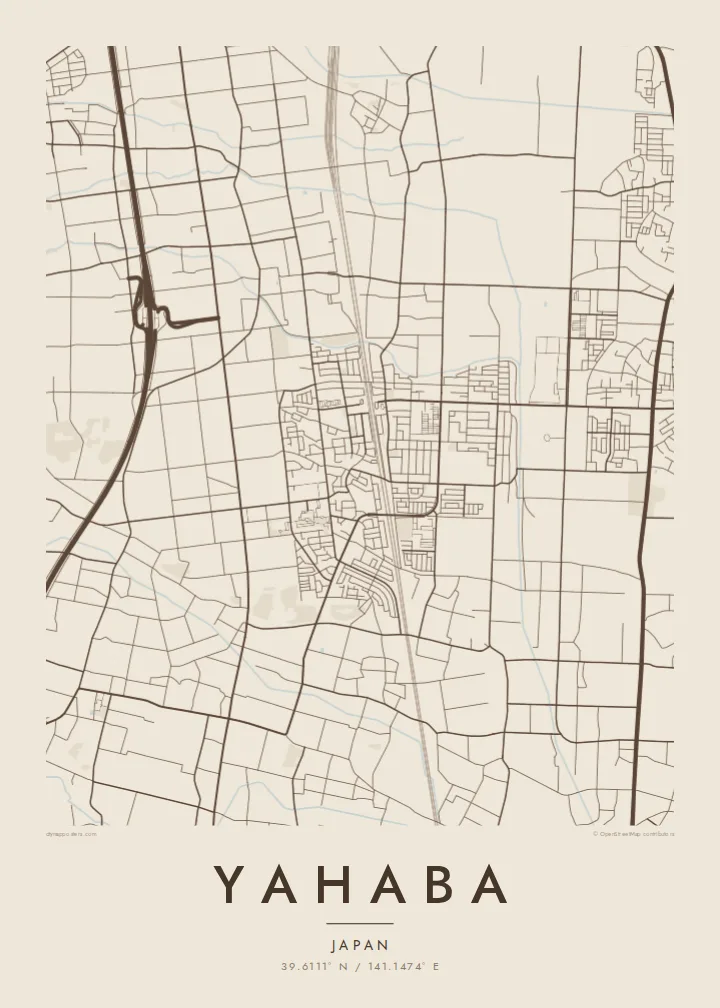
Tohoku's largest river runs along Yahaba, drawing a long, calm line across the poster and marking the eastern edge of the town.
ផូស្ទ័រផែនទីបែបសាមញ្ញ · ជប៉ុន
39.6111° N / 141.1474° E
A quiet town just south of Morioka, laid out between rice paddies and the broad course of the Kitakami River.


ទីក្រុងមួយ អារម្មណ៍ប្រាំ
ចុចលើម៉ូតណាមួយ ដើម្បីមើលវានៅលើជញ្ជាំង។ គ្រប់ម៉ូតទាំងអស់មានតម្លៃដូចគ្នា — មិនថាបោះពុម្ព ធ្វើស៊ុម ឬជាឯកសារ HD។
 ភីកសែលពិតប្រាកដ · ឯកសារបោះពុម្ព 24 × 36″
ច្បាស់ល្អសម្រាប់បោះពុម្ព
នេះជារូបភាពពង្រីក 100% នៃឯកសារបោះពុម្ពពិតប្រាកដ។ ផ្ទាំងគ្រប់សន្លឹក — មិនថាបោះពុម្ព ធ្វើស៊ុម ឬទាញយក — ត្រូវបានបង្កើតនៅលើម៉ាស៊ីនមេរបស់យើងក្នុងគុណភាព 300 DPI រហូតដល់ 7,200 × 10,800 ភីកសែល ដូច្នេះសូម្បីតែផ្លូវតូចបំផុតក៏នៅតែច្បាស់នៅលើក្រដាសបោះពុម្ពទំហំ 24 × 36″។
នៅលើជញ្ជាំង


ផែនទី
Yahaba is a town in Iwate Prefecture, lying just south of the prefectural capital Morioka in the Kitakami River basin. On a map it reads as a residential town grown between the city and open farmland: neighbourhoods of regular blocks sit alongside rectangular rice paddies, with main roads and the railway running north toward Morioka.
The Kitakami River, the largest in the Tohoku region, runs along the town and gives the map a strong natural boundary. To the west the ground rises gradually toward the mountains, while the flatter land nearer the river is divided into the neat geometry of paddy fields, a pattern that looks especially clear in black and white.
A Yahaba map poster balances that order and openness: suburban streets, the ribbon of the river and the grid of fields fading into countryside. It is a gentle map, well suited to someone who grew up here, commutes to Morioka or remembers the town from a stay in Iwate.
Tohoku's largest river runs along Yahaba, drawing a long, calm line across the poster and marking the eastern edge of the town.
Rectangular rice fields surround the built-up areas, adding a precise, almost woven texture to the map between the roads and settlements.
Roads and the railway run north toward Morioka, showing how closely the town is tied to the neighbouring city while keeping its own compact centre.
ធ្វើឱ្យជារបស់អ្នក
បន្ថែមកាលបរិច្ឆេទ ឈ្មោះ ឬឃ្លាផ្ទាល់ខ្លួន ប្ដូររចនាប័ទ្ម ទំហំ ឬទិសដៅ។
គំរូឥតគិតថ្លៃមានគុណភាពទាប និងមានស្លាកសញ្ញាទឹក។ ការបោះពុម្ព និងឯកសារ HD ត្រូវបានបង្កើតក្នុងគុណភាព 300 DPI រហូតដល់ 7,200 × 10,800 px ដោយគ្មានស្លាកសញ្ញាទឹក។
ហេតុអ្វី Yahaba
A map of Yahaba makes a considered gift for someone leaving Iwate, or a reminder of seasons spent among its fields. The clean composition sits comfortably in Japanese and Western interiors alike.
Write your own title and subtitle, add a date and adjust the coordinates line. Styles include Classic black & white, Noir, Paper, Blueprint and Sand, and the free watermarked preview lets you check the framing before you buy.
កម្មង់ផ្ទាំង Yahaba| ទំហំបោះពុម្ព | គុណភាពបង្ហាញ | ឯកសារ |
|---|---|---|
| 30 × 40 cm (11.8 × 15.7″) | 3,543 × 4,724 px | PNG · PDF |
| 29.7 × 42 cm (A3, 11.7 × 16.5″) | 3,508 × 4,961 px | PNG · PDF |
| 42 × 59.4 cm (A2, 16.5 × 23.4″) | 4,961 × 7,016 px | PNG · PDF |
| 45.7 × 61 cm (18 × 24″) | 5,400 × 7,200 px | PNG · PDF |
| 50 × 70 cm (19.7 × 27.6″) | 5,906 × 8,268 px | PNG · PDF |
| 61 × 91.4 cm (24 × 36″) | 7,200 × 10,800 px | PNG · PDF |
ដើម្បីប្រៀបធៀប កំណែមើលជាមុនឥតគិតថ្លៃមានទទឹង 900 px មានស្លាកទឹក និងសម្រាប់មើលលើអេក្រង់។ ឯកសារ HD មានគុណភាពបង្ហាញខ្ពស់ជាងរហូតដល់ 8 ដងគ្រប់ទិស ហើយបោះពុម្ពបានច្បាស់ល្អក្នុងទំហំផូស្ទ័រពេញ។
ជ្រើសរើសម៉ូតនៅផ្នែកខាងលើទំព័រ បន្ទាប់មកជ្រើសរើស ផ្ទាំងបោះពុម្ព — ជ្រើសទំហំ និងស៊ុម (បើចង់) — ឬ ឯកសារឌីជីថល HD។ ការទូទាត់ធ្វើតែមួយជំហាន ហើយទំព័រការកម្មង់របស់អ្នកនឹងធ្វើបច្ចុប្បន្នភាពភ្លាមៗបន្ទាប់ពីទូទាត់ជោគជ័យ។
វាត្រូវបានបោះពុម្ពលើក្រដាសមាត់ខ្នាតខ្ពស់ 200 gsm ប្រភេទស្រអាប់ ក្នុងទំហំចំនួនប្រាំមួយ ចាប់ពី 30 × 40 សម ដល់ 24 × 36″។ ផ្ទាំងបោះពុម្ពមានតម្លៃចាប់ពី $39 រួមការដឹកជញ្ជូន។
បាន។ ជ្រើសរើសស៊ុមឈើសុទ្ធពណ៌ខ្មៅ ស ឈើអុកធម្មជាតិ ឬឈើងងឹត។ វាមកជាមួយកញ្ចក់ធន់នឹងការបែកបាក់ និងអាចព្យួរបានភ្លាមៗ។ ផ្ទាំងមានស៊ុមមានតម្លៃចាប់ពី $99 រួមការដឹកជញ្ជូន។
ការដឹកជញ្ជូនឥតគិតថ្លៃទូទាំងពិភពលោក។ ប៉ុស្ទ័រនីមួយៗត្រូវបានបោះពុម្ពដោយដៃគូបោះពុម្ពដែលនៅជិតបំផុតរបស់យើងក្នុងជាង 30 ប្រទេស ហើយជាទូទៅមកដល់ក្នុងរយៈពេល 3–7 ថ្ងៃធ្វើការ។ អ្នកអាចតាមដានស្ថានភាព និងលេខតាមដានក្នុងផ្នែក ការបញ្ជាទិញរបស់ខ្ញុំ។ ប្រទេសមួយចំនួនត្រូវការពេល 2–5 សប្តាហ៍ ហើយប្រសិនបើយើងមិនទាន់ដឹកជញ្ជូនទៅកន្លែងណា គេហទំព័រនឹងប្រាប់អ្នកមុនពេលអ្នកទូទាត់។
ផ្ញើរូបថតមកយើងក្នុងរយៈពេល 14 ថ្ងៃបន្ទាប់ពីទទួលបាន ហើយយើងនឹងបោះពុម្ពជូនថ្មីដោយឥតគិតថ្លៃ ឬសងប្រាក់វិញ។
បាន។ នៅក្នុងកម្មវិធីកែសម្រួលលើទំព័រនេះ អ្នកអាចផ្លាស់ប្តូរចំណងជើង ចំណងជើងរង និងបន្ទាត់កូអរដោនេទៅជាអ្វីក៏បាន រួចជ្រើសរើសម៉ូត និងទំហំ។ ការកម្មង់ទាំងបោះពុម្ព ស៊ុម និងឌីជីថល សុទ្ធតែប្រើប្រាស់រចនាបថពិតប្រាកដតាមអ្នករចនា។
ក្នុងតម្លៃ $9 អ្នកនឹងទទួលបានឯកសារ PNG និង PDF ត្រៀមបោះពុម្ព គុណភាព 300 DPI ក្នុងទំហំទាំងប្រាំមួយ ដោយគ្មានស្លាកសញ្ញាទឹក សម្រាប់បោះពុម្ពនៅគ្រប់ទីកន្លែង។ មិនទាន់ប្រាកដ? ទាញយកគំរូឥតគិតថ្លៃដែលមានស្លាកសញ្ញាទឹកសាកមើលជាមុនសិន។
