Mikuma River
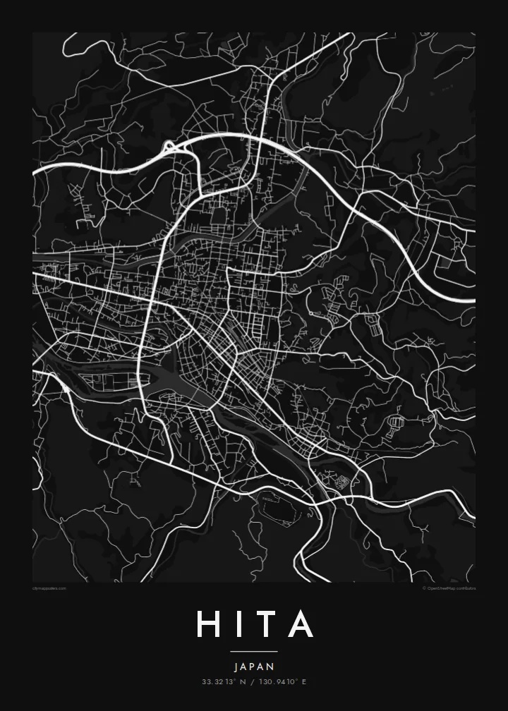
The Mikuma River curves through the heart of the basin, gathering smaller tributaries and dividing the town into districts, the strongest line on the entire map.
미니멀 지도 포스터 · 일본
33.3213° N / 130.9410° E
A mountain basin town gathered around the Mikuma River, its Edo-era merchant streets set among forested Kyushu hills.



하나의 도시, 다섯 가지 분위기
스타일을 선택하면 벽에 걸린 모습을 볼 수 있어요. 모든 스타일은 인쇄, 액자, HD 파일 어떤 방식이든 가격이 같습니다.
 실제 픽셀 · 24 × 36″ 인쇄 파일
선명한 인쇄 품질
실제 인쇄 파일을 100% 크기로 잘라낸 이미지입니다. 인쇄, 액자, 다운로드 등 모든 포스터는 저희 서버에서 300 DPI, 최대 7,200 × 10,800픽셀로 렌더링되어 24 × 36″ 인쇄물에서도 가장 좁은 골목길까지 선명하게 보입니다.
인테리어 속에서


지도 소개
Hita occupies a basin in the west of Oita Prefecture, enclosed by forested mountains on every side. Several rivers flow into the basin and join to form the Mikuma River, which runs through the town before continuing toward the Ariake Sea as the Chikugo River. On the map the rivers are the main event, bending through the urban area and dividing it into a series of distinct districts.
During the Edo period Hita was a directly governed territory of the Tokugawa shogunate, and its merchants grew prosperous. The Mamedamachi district preserves their streets, a compact grid of old warehouses and shops that appears on the poster as a finely drawn cluster. Nearby stood Kangien, the private academy founded by the scholar Hirose Tansō, which drew students from across Japan.
Along the Mikuma River, hot spring inns line the banks, and in summer the river is known for traditional cormorant fishing from wooden boats. Around the town, cedar forests cover the slopes that close in the basin. A Hita map poster places the old town, the river and the mountains in a single, balanced frame.
The Mikuma River curves through the heart of the basin, gathering smaller tributaries and dividing the town into districts, the strongest line on the entire map.
The preserved merchant district of Mamedamachi forms a small, dense grid of historic streets, a finely detailed cluster that recalls Hita's Edo-period wealth.
Forested slopes rise on all sides of the basin, and the roads that climb out of town follow the valleys in long winding lines toward the edges.
나만의 포스터로
날짜, 이름 또는 원하는 문구를 추가하고 스타일, 사이즈, 방향을 바꿔 보세요.
무료 미리보기는 저해상도이며 워터마크가 있습니다. 인쇄물과 HD 파일은 300 DPI, 최대 7,200 × 10,800px로 워터마크 없이 렌더링됩니다.
왜 Hita인가
Hita rewards a close look, much like its old streets reward a slow walk, and a map of the town suits anyone who has stayed by the river or grown up among its hills. The basin shape makes a naturally framed composition.
Paper and Sand bring out the warmth of the old town, while Noir and Blueprint give the rivers a sharper edge, and Classic black & white keeps it simple. Personalise the title, subtitle and coordinates, then download six print sizes for $9.
Hita 포스터 주문하기| 인쇄 사이즈 | 해상도 | 파일 |
|---|---|---|
| 30 × 40 cm11.8 × 15.7″ | 3,543 × 4,724 px | PNG · PDF |
| 29.7 × 42 cm (A3)11.7 × 16.5″ | 3,508 × 4,961 px | PNG · PDF |
| 42 × 59.4 cm (A2)16.5 × 23.4″ | 4,961 × 7,016 px | PNG · PDF |
| 45.7 × 61 cm18 × 24″ | 5,400 × 7,200 px | PNG · PDF |
| 50 × 70 cm19.7 × 27.6″ | 5,906 × 8,268 px | PNG · PDF |
| 61 × 91.4 cm24 × 36″ | 7,200 × 10,800 px | PNG · PDF |
참고로 무료 미리보기는 가로 900 px에 워터마크가 포함된 화면용 이미지입니다. HD 파일은 가로세로 각각 최대 8배의 해상도로, 포스터 원본 크기로도 깔끔하게 인쇄됩니다.
페이지 상단에서 스타일을 선택한 다음, 인쇄 포스터(사이즈, 원하면 액자까지)나 디지털 HD 파일 중 하나를 고르세요. 결제는 한 단계로 끝나며, 결제가 완료되는 즉시 주문 페이지가 업데이트됩니다.
프리미엄 200 gsm 무광 용지에 인쇄되며, 30 × 40 cm부터 24 × 36″까지 6가지 사이즈 중에서 고를 수 있습니다. 인쇄 포스터는 배송비 포함 $39부터 시작합니다.
네, 가능합니다. 블랙, 화이트, 내추럴 오크, 다크 우드 중 원목 액자를 선택할 수 있습니다. 강화 아크릴이 포함되어 있어 바로 걸 수 있습니다. 액자 포스터는 배송비 포함 $99부터 시작합니다.
60개국 이상으로 무료 배송됩니다. 포스터는 30개국 이상에 있는 제휴 인쇄소 중 가장 가까운 곳에서 인쇄되어 보통 영업일 기준 3~7일 안에 도착합니다. 진행 상황과 배송 추적은 '내 주문'에서 확인하실 수 있습니다. 일부 국가는 2~5주가 걸리며, 아직 배송하지 않는 국가는 결제 전에 사이트에서 안내해 드립니다.
배송 후 14일 이내에 사진을 보내주시면 무료로 재인쇄해 드리거나 환불해 드립니다.
네, 가능합니다. 이 페이지의 편집기에서 제목, 부제목, 좌표 줄을 원하는 대로 바꾸고 스타일과 사이즈를 선택하세요. 인쇄, 액자, 디지털 주문 모두 고객님이 만든 디자인 그대로 제작됩니다.
$9에 300 DPI PNG과 인쇄 가능한 PDF 파일을 6가지 사이즈 모두, 워터마크 없이 받아 어디서든 인쇄할 수 있습니다. 아직 고민 중이시라면 워터마크가 있는 무료 미리보기를 먼저 다운로드해 보세요.
