Al-Manara Square
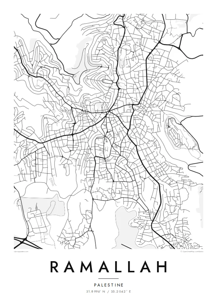
The central roundabout where major streets converge forms the heart of the map. The downtown pattern spreads out from this single point.
미니멀 지도 포스터 · 팔레스타인 지구
31.8996° N / 35.2042° E
A hilltop city north of Jerusalem, with streets winding over ridges and descending into terraced valleys


하나의 도시, 다섯 가지 분위기
스타일을 선택하면 벽에 걸린 모습을 볼 수 있어요. 모든 스타일은 인쇄, 액자, HD 파일 어떤 방식이든 가격이 같습니다.
 실제 픽셀 · 24 × 36″ 인쇄 파일
선명한 인쇄 품질
실제 인쇄 파일을 100% 크기로 잘라낸 이미지입니다. 인쇄, 액자, 다운로드 등 모든 포스터는 저희 서버에서 300 DPI, 최대 7,200 × 10,800픽셀로 렌더링되어 24 × 36″ 인쇄물에서도 가장 좁은 골목길까지 선명하게 보입니다.
인테리어 속에서


지도 소개
Ramallah sits high in the central hills of the West Bank, about 15 kilometres north of Jerusalem, at an elevation of around 800 metres or more. Its street plan is shaped by the terrain. Roads follow ridgelines and curve down into wadis, and many blocks are irregular because the ground rarely stays flat for long. Ramallah merges with the neighbouring city of al-Bireh, and the two form one continuous urban area.
At the centre is al-Manara Square, a roundabout where several main streets meet. It is the most recognisable point on the map. The city also serves as the administrative centre of the Palestinian Authority, and the Muqata'a compound includes the mausoleum of Yasser Arafat. Beyond the built-up edge, the map shows olive terraces and surrounding villages across the hills.
A Ramallah map poster shows a city defined by the land it stands on. Contour-following streets and scattered neighbourhoods on separate hills make it very different from a flat-plain city. For Palestinians at home and abroad, the map offers a way to hold a familiar place quietly and precisely.
The central roundabout where major streets converge forms the heart of the map. The downtown pattern spreads out from this single point.
Roads curve along ridges and drop into valleys, producing irregular blocks and flowing lines that clearly reflect the steep terrain beneath them.
Ramallah and al-Bireh run together without a visible break, forming one continuous urban area across several adjoining hills.
나만의 포스터로
날짜, 이름 또는 원하는 문구를 추가하고 스타일, 사이즈, 방향을 바꿔 보세요.
무료 미리보기는 저해상도이며 워터마크가 있습니다. 인쇄물과 HD 파일은 300 DPI, 최대 7,200 × 10,800px로 워터마크 없이 렌더링됩니다.
왜 Ramallah인가
For many in the Palestinian diaspora, Ramallah is where family, work and memory meet. A precise, unadorned map lets the place speak for itself, without slogans or souvenir imagery. It suits a home, a studio or an office.
You can set the title in any form you prefer, add a neighbourhood or year in the subtitle, and keep or edit the coordinates. There are five styles to choose from. Sand and Paper suit the stone-coloured hills, and Noir brings out the winding streets most strongly.
Ramallah 포스터 주문하기| 인쇄 사이즈 | 해상도 | 파일 |
|---|---|---|
| 30 × 40 cm (11.8 × 15.7″) | 3,543 × 4,724 px | PNG · PDF |
| 29.7 × 42 cm (A3, 11.7 × 16.5″) | 3,508 × 4,961 px | PNG · PDF |
| 42 × 59.4 cm (A2, 16.5 × 23.4″) | 4,961 × 7,016 px | PNG · PDF |
| 45.7 × 61 cm (18 × 24″) | 5,400 × 7,200 px | PNG · PDF |
| 50 × 70 cm (19.7 × 27.6″) | 5,906 × 8,268 px | PNG · PDF |
| 61 × 91.4 cm (24 × 36″) | 7,200 × 10,800 px | PNG · PDF |
참고로 무료 미리보기는 가로 900 px에 워터마크가 포함된 화면용 이미지입니다. HD 파일은 가로세로 각각 최대 8배의 해상도로, 포스터 원본 크기로도 깔끔하게 인쇄됩니다.
페이지 상단에서 스타일을 선택한 다음, 인쇄 포스터(사이즈, 원하면 액자까지)나 디지털 HD 파일 중 하나를 고르세요. 결제는 한 단계로 끝나며, 결제가 완료되는 즉시 주문 페이지가 업데이트됩니다.
프리미엄 200 gsm 무광 용지에 인쇄되며, 30 × 40 cm부터 24 × 36″까지 6가지 사이즈 중에서 고를 수 있습니다. 인쇄 포스터는 배송비 포함 {printFrom}부터 시작합니다.
네, 가능합니다. 블랙, 화이트, 내추럴 오크, 다크 우드 중 원목 액자를 선택할 수 있습니다. 강화 아크릴이 포함되어 있어 바로 걸 수 있습니다. 액자 포스터는 배송비 포함 {framedFrom}부터 시작합니다.
전 세계 무료 배송입니다. 각 포스터는 30여 개국에 있는 인쇄 파트너 중 가장 가까운 곳에서 인쇄되며, 보통 영업일 기준 3~7일 내에 도착합니다. 주문 현황과 배송 조회는 '내 주문'에서 확인할 수 있습니다.
배송 후 14일 이내에 사진을 보내주시면 무료로 재인쇄해 드리거나 환불해 드립니다.
네, 가능합니다. 이 페이지의 편집기에서 제목, 부제목, 좌표 줄을 원하는 대로 바꾸고 스타일과 사이즈를 선택하세요. 인쇄, 액자, 디지털 주문 모두 고객님이 만든 디자인 그대로 제작됩니다.
$9에 300 DPI PNG과 인쇄 가능한 PDF 파일을 6가지 사이즈 모두, 워터마크 없이 받아 어디서든 인쇄할 수 있습니다. 아직 고민 중이시라면 워터마크가 있는 무료 미리보기를 먼저 다운로드해 보세요.
