The Gier corridor
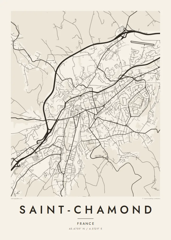
The river, the railway and the main roads run through the valley together, forming a strong diagonal line that sets the direction of the whole map.
미니멀 지도 포스터 · 프랑스
45.4759° N / 4.5129° E
A long industrial town stretched along the narrow Gier valley, with the road, the rail line and the river running side by side




하나의 도시, 다섯 가지 분위기
스타일을 선택하면 벽에 걸린 모습을 볼 수 있어요. 모든 스타일은 인쇄, 액자, HD 파일 어떤 방식이든 가격이 같습니다.
 실제 픽셀 · 24 × 36″ 인쇄 파일
선명한 인쇄 품질
실제 인쇄 파일을 100% 크기로 잘라낸 이미지입니다. 인쇄, 액자, 다운로드 등 모든 포스터는 저희 서버에서 300 DPI, 최대 7,200 × 10,800픽셀로 렌더링되어 24 × 36″ 인쇄물에서도 가장 좁은 골목길까지 선명하게 보입니다.
인테리어 속에서


지도 소개
Saint-Chamond sits in the Gier valley in the Loire department, between Saint-Étienne and the Rhône. On a map the town is long and narrow, shaped by the valley floor. The main roads, the railway and the river all run roughly parallel from southwest to northeast, and housing climbs the slopes on either side until the terrain gets too steep to build on.
For well over a century the town was an industrial centre. Ribbon and braid workshops came first, followed by heavy steelworks. The forges here gave their name to the Saint-Chamond tank, one of the first French armoured vehicles of the First World War. The large former factory grounds near the centre have since been redeveloped, and they still show up in the street plan as a broad, open block among the older, denser streets.
A Saint-Chamond map poster shows that valley layout clearly: a dense central band, secondary streets branching into side valleys, and the outline of the old town where the lanes are closer together. To the south the streets thin out towards the wooded heights of the Pilat regional park, and that fading of the grid gives the print a natural edge.
The river, the railway and the main roads run through the valley together, forming a strong diagonal line that sets the direction of the whole map.
The old industrial site near the centre appears as a wide block with a looser pattern of streets, a trace of the forges that once employed much of the town.
On both sides of the valley the grid breaks into winding roads and short cul-de-sacs as it reaches steeper ground, giving the edges of the map a softer, uneven texture.
나만의 포스터로
날짜, 이름 또는 원하는 문구를 추가하고 스타일, 사이즈, 방향을 바꿔 보세요.
무료 미리보기는 저해상도이며 워터마크가 있습니다. 인쇄물과 HD 파일은 300 DPI, 최대 7,200 × 10,800px로 워터마크 없이 렌더링됩니다.
왜 Saint-Chamond인가
People who grew up in the Gier valley, or worked in its factories, often want the place they know as a real shape on the wall. The long, directional outline of Saint-Chamond makes for an unusual composition, quite different from a round city centre.
You can change the title, subtitle and coordinates line to mark a family name, a street or a year, and choose one of five styles: Classic black & white, Noir, Paper, Blueprint or Sand. It comes as a $9 digital download or as a printed poster on matte paper, with an optional wooden frame.
Saint-Chamond 포스터 주문하기| 인쇄 사이즈 | 해상도 | 파일 |
|---|---|---|
| 30 × 40 cm (11.8 × 15.7″) | 3,543 × 4,724 px | PNG · PDF |
| 29.7 × 42 cm (A3, 11.7 × 16.5″) | 3,508 × 4,961 px | PNG · PDF |
| 42 × 59.4 cm (A2, 16.5 × 23.4″) | 4,961 × 7,016 px | PNG · PDF |
| 45.7 × 61 cm (18 × 24″) | 5,400 × 7,200 px | PNG · PDF |
| 50 × 70 cm (19.7 × 27.6″) | 5,906 × 8,268 px | PNG · PDF |
| 61 × 91.4 cm (24 × 36″) | 7,200 × 10,800 px | PNG · PDF |
참고로 무료 미리보기는 가로 900 px에 워터마크가 포함된 화면용 이미지입니다. HD 파일은 가로세로 각각 최대 8배의 해상도로, 포스터 원본 크기로도 깔끔하게 인쇄됩니다.
페이지 상단에서 스타일을 선택한 다음, 인쇄 포스터(사이즈, 원하면 액자까지)나 디지털 HD 파일 중 하나를 고르세요. 결제는 한 단계로 끝나며, 결제가 완료되는 즉시 주문 페이지가 업데이트됩니다.
프리미엄 200 gsm 무광 용지에 인쇄되며, 30 × 40 cm부터 24 × 36″까지 6가지 사이즈 중에서 고를 수 있습니다. 인쇄 포스터는 배송비 포함 $39부터 시작합니다.
네, 가능합니다. 블랙, 화이트, 내추럴 오크, 다크 우드 중 원목 액자를 선택할 수 있습니다. 강화 아크릴이 포함되어 있어 바로 걸 수 있습니다. 액자 포스터는 배송비 포함 $99부터 시작합니다.
배송비는 전 세계 무료입니다. 포스터는 30개국 이상에 있는 제작 파트너 중 가장 가까운 곳에서 인쇄되며, 보통 영업일 기준 3~7일 안에 도착합니다. 진행 상황과 배송 조회는 '내 주문'에서 확인하실 수 있습니다. 일부 국가는 2~5주가 걸리고, 아직 배송하지 않는 국가는 결제 전에 사이트에서 안내해 드립니다.
배송 후 14일 이내에 사진을 보내주시면 무료로 재인쇄해 드리거나 환불해 드립니다.
네, 가능합니다. 이 페이지의 편집기에서 제목, 부제목, 좌표 줄을 원하는 대로 바꾸고 스타일과 사이즈를 선택하세요. 인쇄, 액자, 디지털 주문 모두 고객님이 만든 디자인 그대로 제작됩니다.
$9에 300 DPI PNG과 인쇄 가능한 PDF 파일을 6가지 사이즈 모두, 워터마크 없이 받아 어디서든 인쇄할 수 있습니다. 아직 고민 중이시라면 워터마크가 있는 무료 미리보기를 먼저 다운로드해 보세요.
