Spokane Falls
Near downtown the river tumbles over a series of basalt ledges. These are the falls that first drew settlement here, and they still set the city's orientation.
미니멀 지도 포스터 · 미국
47.6597° N / 117.4291° W
A river city of falls and bridges, its downtown grid split by the Spokane River and climbing onto the South Hill


하나의 도시, 다섯 가지 분위기
스타일을 선택하면 벽에 걸린 모습을 볼 수 있어요. 모든 스타일은 인쇄, 액자, HD 파일 어떤 방식이든 가격이 같습니다.
 실제 픽셀 · 24 × 36″ 인쇄 파일
선명한 인쇄 품질
실제 인쇄 파일을 100% 크기로 잘라낸 이미지입니다. 인쇄, 액자, 다운로드 등 모든 포스터는 저희 서버에서 300 DPI, 최대 7,200 × 10,800픽셀로 렌더링되어 24 × 36″ 인쇄물에서도 가장 좁은 골목길까지 선명하게 보입니다.
인테리어 속에서


지도 소개
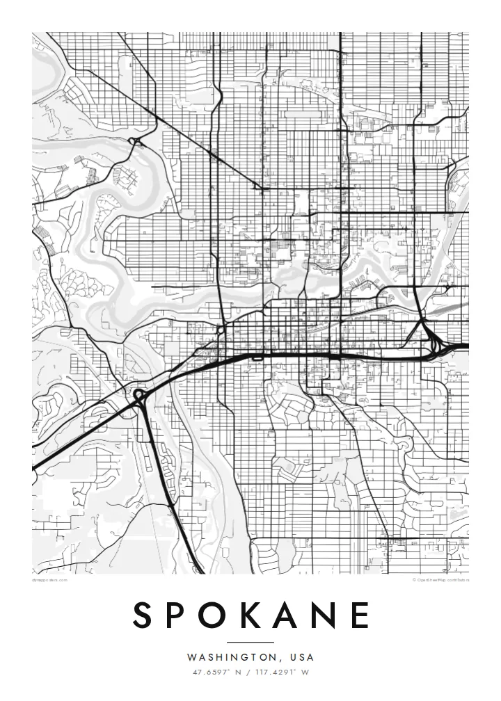
Spokane grew up around a set of waterfalls on the Spokane River, and the river still runs straight through the heart of the city. On the map it arrives from the east, splits around islands near downtown, drops over the falls and then winds away north-west in a deep gorge. The downtown grid sits right beside it, with bridges crossing at close intervals.
Riverfront Park fills the islands and banks at the centre. The site hosted the 1974 World's Fair, when the railyards there were cleared. Just downstream, the Monroe Street Bridge crosses the gorge on a broad concrete arch. South of downtown the land rises sharply onto the South Hill, where the streets start to bend around slopes and parks.
Beyond the centre, the grid extends in long, regular blocks across the valley floor toward the north and east. Arterial roads break it up, and the campus of Gonzaga University sits near the river. A Spokane map poster shows how firmly the city is anchored to its water, with every neighbourhood arranged in relation to that one bending line.
Near downtown the river tumbles over a series of basalt ledges. These are the falls that first drew settlement here, and they still set the city's orientation.
The islands and banks of the river form a large park at the centre, a green space created for Expo '74 and now crossed by footbridges and paths.
South of downtown the streets climb a steep rise, and the regular grid gives way to curving roads, terraces and parkland that read clearly on the map.
나만의 포스터로
날짜, 이름 또는 원하는 문구를 추가하고 스타일, 사이즈, 방향을 바꿔 보세요.
무료 미리보기는 저해상도이며 워터마크가 있습니다. 인쇄물과 HD 파일은 300 DPI, 최대 7,200 × 10,800px로 워터마크 없이 렌더링됩니다.
왜 Spokane인가
People connect with Spokane through its river: a walk around the falls, a college year near Gonzaga, a house on the South Hill. A map collects those places into one frame, which is why it works so well as a housewarming or graduation gift.
Each poster can carry your own title, subtitle and coordinates, and comes in Classic black and white, Noir, Paper, Blueprint or Sand. Buy the digital files for $9, including 18×24″ and 24×36″ sizes, or order a printed poster with an optional wooden frame.
Spokane 포스터 주문하기| 인쇄 사이즈 | 해상도 | 파일 |
|---|---|---|
| 30 × 40 cm (11.8 × 15.7″) | 3,543 × 4,724 px | PNG · PDF |
| 29.7 × 42 cm (A3, 11.7 × 16.5″) | 3,508 × 4,961 px | PNG · PDF |
| 42 × 59.4 cm (A2, 16.5 × 23.4″) | 4,961 × 7,016 px | PNG · PDF |
| 45.7 × 61 cm (18 × 24″) | 5,400 × 7,200 px | PNG · PDF |
| 50 × 70 cm (19.7 × 27.6″) | 5,906 × 8,268 px | PNG · PDF |
| 61 × 91.4 cm (24 × 36″) | 7,200 × 10,800 px | PNG · PDF |
참고로 무료 미리보기는 가로 900 px에 워터마크가 포함된 화면용 이미지입니다. HD 파일은 가로세로 각각 최대 8배의 해상도로, 포스터 원본 크기로도 깔끔하게 인쇄됩니다.
페이지 상단에서 스타일을 선택한 다음, 인쇄 포스터(사이즈, 원하면 액자까지)나 디지털 HD 파일 중 하나를 고르세요. 결제는 한 단계로 끝나며, 결제가 완료되는 즉시 주문 페이지가 업데이트됩니다.
프리미엄 200 gsm 무광 용지에 인쇄되며, 30 × 40 cm부터 24 × 36″까지 6가지 사이즈 중에서 고를 수 있습니다. 인쇄 포스터는 배송비 포함 {printFrom}부터 시작합니다.
네, 가능합니다. 블랙, 화이트, 내추럴 오크, 다크 우드 중 원목 액자를 선택할 수 있습니다. 강화 아크릴이 포함되어 있어 바로 걸 수 있습니다. 액자 포스터는 배송비 포함 {framedFrom}부터 시작합니다.
전 세계 무료 배송입니다. 각 포스터는 30여 개국에 있는 인쇄 파트너 중 가장 가까운 곳에서 인쇄되며, 보통 영업일 기준 3~7일 내에 도착합니다. 주문 현황과 배송 조회는 '내 주문'에서 확인할 수 있습니다.
배송 후 14일 이내에 사진을 보내주시면 무료로 재인쇄해 드리거나 환불해 드립니다.
네, 가능합니다. 이 페이지의 편집기에서 제목, 부제목, 좌표 줄을 원하는 대로 바꾸고 스타일과 사이즈를 선택하세요. 인쇄, 액자, 디지털 주문 모두 고객님이 만든 디자인 그대로 제작됩니다.
$9에 300 DPI PNG과 인쇄 가능한 PDF 파일을 6가지 사이즈 모두, 워터마크 없이 받아 어디서든 인쇄할 수 있습니다. 아직 고민 중이시라면 워터마크가 있는 무료 미리보기를 먼저 다운로드해 보세요.
