Ming city wall
One of the longest surviving city walls in the world, following ridges and lakeshores for more than twenty kilometres. On the poster it forms an irregular loop around the historic core.
Minimalistesche Kaarteposter · China
32.0617° N / 118.7778° E
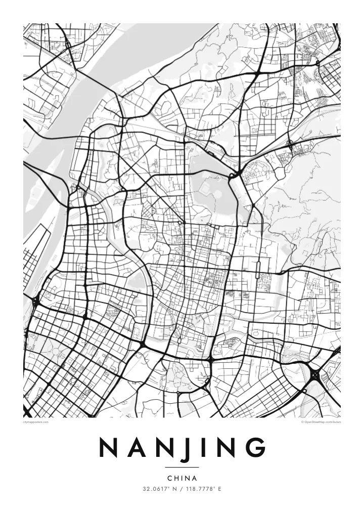
The Yangtze sweeping past a Ming-walled city, with Xuanwu Lake pressed against the wall and Purple Mountain rising east.


Eng Stad, fënnef Stëmmungen
Tipp op e Stil fir en un der Wand ze gesinn. All Stil kascht d'selwecht — gedréckt, geframt oder als HD-Dateien.
 Richteg Pixel · 24 × 36″ Print-Datei
Gestach schaarf
Dëst ass en 100%-Ausschnitt vun der richteger Print-Datei. All Poster — gedréckt, geframt oder erofgeluede — gëtt op eise Serveren mat 300 DPI gerendert, bis zu 7,200 × 10,800 Pixel, sou datt och déi klengst Stroossen op engem 24 × 36″-Print scharf bleiwen.
un der Mauer


D'Kaart
Nanjing lies on the southern bank of the Yangtze, where the river turns northeast, and the city has faced the water for well over two thousand years. Its most distinctive feature from above is the Ming city wall, built in the fourteenth century and still standing along much of its length. The line bends irregularly around hills and lakes rather than forming a neat rectangle.
Inside and around the wall, the city is full of water. Xuanwu Lake lies just beyond the northern stretch, the Qinhuai River curves through the south past the Confucius Temple district, and moats follow the old fortifications. East of the centre, Purple Mountain carries the Sun Yat-sen Mausoleum and the Ming Xiaoling tomb within a large forested area, which reads as open space on the map.
Nanjing served as the capital of China under several dynasties and governments, which explains its ceremonial avenues and monumental gates. Zhonghua Gate in the south is one of the largest surviving city gates in China. A Nanjing map poster frames the river, the wall and the mountain together, the three features most often cited in explaining why the city was chosen as a capital.
One of the longest surviving city walls in the world, following ridges and lakeshores for more than twenty kilometres. On the poster it forms an irregular loop around the historic core.
The river that loops through southern Nanjing, running both outside and inside the wall, past the Confucius Temple and its old lanes. Its bends define the southern edge of the old city.
The forested mountain east of the walls holds the Sun Yat-sen Mausoleum, the Ming Xiaoling tomb and an observatory. On the map it appears as a large, calm area of paths and slopes.
Maacht en zu Ärem eegenen
Setzt en Datum, en Numm oder eng eegen Zeil derbäi, wiesselt Stil, Gréisst oder Orientéierung.
D'gratis Preview ass a niddereger Opléisung mat enger Waassermark. Prints an HD-Dateien gi mat 300 DPI gerendert, bis zu 7,200 × 10,800 px, ouni Waassermark.
Firwat Nanjing
Nanjing is a city people study in, and many graduates of its universities carry a lasting attachment to its plane-tree avenues and old gates. A map of the walled city is a way of keeping those years in view, long after leaving.
Set your own title and subtitle, perhaps a graduation year, and edit the coordinates line if you like. Choose from five styles; Paper and Sand suit the old wall, Blueprint the river crossings. Order the HD files or a matte print with an optional wooden frame.
Bestell den Nanjing-Poster| Drockgréisst | Opléisung | Dateien |
|---|---|---|
| 30 × 40 cm (11.8 × 15.7″) | 3,543 × 4,724 px | PNG · PDF |
| 29.7 × 42 cm (A3, 11.7 × 16.5″) | 3,508 × 4,961 px | PNG · PDF |
| 42 × 59.4 cm (A2, 16.5 × 23.4″) | 4,961 × 7,016 px | PNG · PDF |
| 45.7 × 61 cm (18 × 24″) | 5,400 × 7,200 px | PNG · PDF |
| 50 × 70 cm (19.7 × 27.6″) | 5,906 × 8,268 px | PNG · PDF |
| 61 × 91.4 cm (24 × 36″) | 7,200 × 10,800 px | PNG · PDF |
Zum Verglach: Déi gratis Virschau ass 900 px breet, huet e Waasserzeechen an ass fir de Bildschierm geduecht. D'HD-Dateien hunn a jiddwer Richtung bis zu 8× d'Opléisung a loossen sech och a voller Postergréisst propper drécken.
Wiel e Stil uewen op der Säit aus, duerno entscheed dech fir Gedréckte Poster — eng Gréisst a, wann s de wëlls, e Kader — oder Digital HD-Dateien. D'Keess ass an engem Schrëtt gemaach, an deng Bestellungssäit gëtt aktualiséiert soubal d'Bezuelung duerch ass.
Hie gëtt op héichwäertegt mattes 200-g/m²-Pabeier gedréckt, an enger vu sechs Gréissten, vun 30 × 40 cm bis 24 × 36″. Gedréckte Poster fänken bei $39 un, Liwwerung inklusiv.
Jo. Wiel e Kader aus massivem Holz a schwaarz, wäiss, natierlecher Eech oder donkelem Holz. Hien huet eng bruchsécher Verglasung a ka sou opgehaange ginn. Geframte Poster fänken bei $99 un, Liwwerung inklusiv.
De Versand ass weltwäit gratis. All Poster gëtt vum nootste vun eise Dréckpartner an 30+ Länner gedréckt a kënnt normalerweis bannent 3–7 Wochendeeg un. De Status an d'Tracking fënns du ënner Meng Bestellungen. A puer Länner brauchen 2–5 Woche, a wou mir nach net liwweren, seet dir de Site dat, ier du bezuels.
Schéck eis bannent 14 Deeg no der Liwwerung e Foto, a mir drécken en gratis nach eng Kéier oder erstatten dir de Präis.
Jo. Am Editor op dëser Säit kanns de den Titel, den Ënnertitel an d'Koordinatenzeil op alles änneren, wat s de wëlls, a e Stil an eng Gréisst auswielen. Gedréckt, geframt a digital Bestellungen benotzen alleguer genau däi Design.
Fir $9 kriss de 300 DPI PNG- an drockprett PDF-Dateien a all sechs Gréissten, ouni Waassermarken, fir iwwerall ze drécken. Nach net sécher? Lued fir d'éischt eng gratis Preview mat Waassermark erof.
An der Géigend
