The hills
Rocky hills rise within the city, drawn as green patches and winding streets that break up the flatter surrounding grid.
Minimalistesche Kaarteposter · Bulgarien
42.1539° N / 24.7500° E
An ancient city built around rocky hills on the Maritsa, with a Roman theatre carved into the slopes




Eng Stad, fënnef Stëmmungen
Tipp op e Stil fir en un der Wand ze gesinn. All Stil kascht d'selwecht — gedréckt, geframt oder als HD-Dateien.
 Richteg Pixel · 24 × 36″ Print-Datei
Gestach schaarf
Dëst ass en 100%-Ausschnitt vun der richteger Print-Datei. All Poster — gedréckt, geframt oder erofgeluede — gëtt op eise Serveren mat 300 DPI gerendert, bis zu 7,200 × 10,800 Pixel, sou datt och déi klengst Stroossen op engem 24 × 36″-Print scharf bleiwen.
un der Mauer


D'Kaart
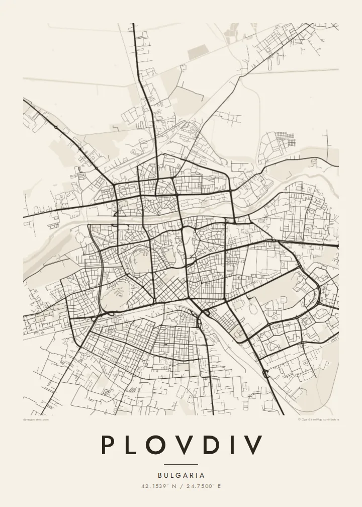
Plovdiv lies on the Maritsa River, which runs west to east along the northern side of the centre. The city is famous for its hills, rocky outcrops rising out of the plain, several of which stand within the urban area. On the map they appear as islands of green and irregular streets, with the flatter districts spreading out between them.
The old town sits on a group of three hills near the river, its narrow streets winding up between restored nineteenth-century houses. Just below lies the Roman theatre, still used for performances. The main pedestrian street runs south from the old town, and beneath it are the remains of a Roman stadium. To the west, a long rowing canal forms one of the straightest lines on the map.
A Plovdiv map poster captures one of the oldest continuously inhabited cities in Europe, with settlement going back thousands of years. It was European Capital of Culture in 2019. From above, the layers are clear: the river, the hills, the old town and the modern grid spreading across the Thracian plain.
Rocky hills rise within the city, drawn as green patches and winding streets that break up the flatter surrounding grid.
Narrow lanes climb the three hills of the old town, with the Roman theatre set into the slope just below them.
A long, straight rowing canal runs parallel to the Maritsa on the western side of the city, one of the most geometric features on the map.
Maacht en zu Ärem eegenen
Setzt en Datum, en Numm oder eng eegen Zeil derbäi, wiesselt Stil, Gréisst oder Orientéierung.
D'gratis Preview ass a niddereger Opléisung mat enger Waassermark. Prints an HD-Dateien gi mat 300 DPI gerendert, bis zu 7,200 × 10,800 px, ouni Waassermark.
Firwat Plovdiv
Visitors, students and families from Plovdiv often remember the view from the hills over the rooftops. A map of the city holds that view in a calm, graphic form suited to a living room or study.
Add a title, subtitle and coordinates of your choice, and choose from five styles. Digital HD files for $9 come in six print sizes, each as a 300 DPI PNG and a print-ready PDF.
Bestell den Plovdiv-Poster| Drockgréisst | Opléisung | Dateien |
|---|---|---|
| 30 × 40 cm (11.8 × 15.7″) | 3,543 × 4,724 px | PNG · PDF |
| 29.7 × 42 cm (A3, 11.7 × 16.5″) | 3,508 × 4,961 px | PNG · PDF |
| 42 × 59.4 cm (A2, 16.5 × 23.4″) | 4,961 × 7,016 px | PNG · PDF |
| 45.7 × 61 cm (18 × 24″) | 5,400 × 7,200 px | PNG · PDF |
| 50 × 70 cm (19.7 × 27.6″) | 5,906 × 8,268 px | PNG · PDF |
| 61 × 91.4 cm (24 × 36″) | 7,200 × 10,800 px | PNG · PDF |
Zum Verglach: Déi gratis Virschau ass 900 px breet, huet e Waasserzeechen an ass fir de Bildschierm geduecht. D'HD-Dateien hunn a jiddwer Richtung bis zu 8× d'Opléisung a loossen sech och a voller Postergréisst propper drécken.
Wiel e Stil uewen op der Säit aus, duerno entscheed dech fir Gedréckte Poster — eng Gréisst a, wann s de wëlls, e Kader — oder Digital HD-Dateien. D'Keess ass an engem Schrëtt gemaach, an deng Bestellungssäit gëtt aktualiséiert soubal d'Bezuelung duerch ass.
Hie gëtt op héichwäertegt mattes 200-g/m²-Pabeier gedréckt, an enger vu sechs Gréissten, vun 30 × 40 cm bis 24 × 36″. Gedréckte Poster fänken bei {printFrom} un, Liwwerung inklusiv.
Jo. Wiel e Kader aus massivem Holz a schwaarz, wäiss, natierlecher Eech oder donkelem Holz. Hien huet eng bruchsécher Verglasung a ka sou opgehaange ginn. Geframte Poster fänken bei {framedFrom} un, Liwwerung inklusiv.
D'Liwwerung ass weltwäit gratis. All Poster gëtt vum nootste vun eise Print-Partner a méi wéi 30 Länner gedréckt an kënnt normalerweis a 3–7 Aarbechtsdeeg un. Du kanns de Status an d'Tracking ënner Meng Bestellungen verfollegen.
Schéck eis bannent 14 Deeg no der Liwwerung e Foto, a mir drécken en gratis nach eng Kéier oder erstatten dir de Präis.
Jo. Am Editor op dëser Säit kanns de den Titel, den Ënnertitel an d'Koordinatenzeil op alles änneren, wat s de wëlls, a e Stil an eng Gréisst auswielen. Gedréckt, geframt a digital Bestellungen benotzen alleguer genau däi Design.
Fir $9 kriss de 300 DPI PNG- an drockprett PDF-Dateien a all sechs Gréissten, ouni Waassermarken, fir iwwerall ze drécken. Nach net sécher? Lued fir d'éischt eng gratis Preview mat Waassermark erof.
An der Géigend
