Niger–Benue confluence
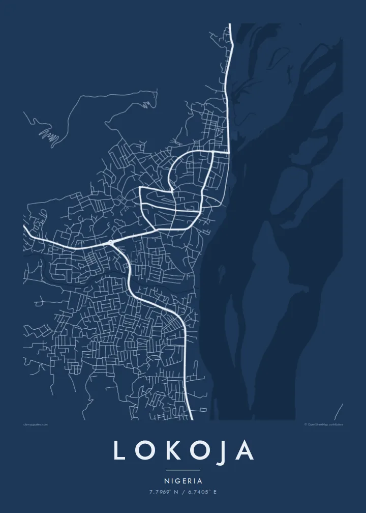
The meeting of Nigeria's two largest rivers dominates the map, a broad Y of open water with sandbars and islands that makes the town's position instantly recognisable.
ໂປສເຕີແຜນທີ່ແບບມິນິມອລ · ໄນຈີເຣຍ
7.7969° N / 6.7405° E
Two great rivers meet in a wide Y beneath a flat-topped hill, with the town strung along the western bank.



ເມືອງດຽວ, ຫ້າບັນຍາກາດ
ແຕະເລືອກສະໄຕລ໌ເພື່ອເບິ່ງຢູ່ເທິງຝາ. ທຸກສະໄຕລ໌ລາຄາເທົ່າກັນ — ພິມ, ໃສ່ກອບ ຫຼື ເປັນໄຟລ໌ HD.
 ພິກເຊວຈິງ · ໄຟລ໌ພິມ 24 × 36″
ຄົມຊັດພ້ອມພິມ
ນີ້ແມ່ນພາບຕັດ 100% ຈາກໄຟລ໌ພິມຕົວຈິງ. ໂປສເຕີທຸກໃບ — ພິມ, ໃສ່ກອບ ຫຼື ດາວໂຫຼດ — ຖືກສ້າງຢູ່ເຊີບເວີຂອງພວກເຮົາທີ່ 300 DPI, ສູງເຖິງ 7,200 × 10,800 ພິກເຊວ, ດັ່ງນັ້ນເສັ້ນທາງນ້ອຍທີ່ສຸດກໍ່ຍັງຄົມຊັດເມື່ອພິມຂະໜາດ 24 × 36″.
ຢູ່ເທິງຝາ


ແຜນທີ່
Lokoja sits where the Niger and the Benue join, and on a map that confluence is the whole composition. Two broad channels arrive from the north-west and north-east, merge into a single river flowing south, and leave sandbanks and braided islands in their wake. The town itself runs along the west bank in a narrow band, held between the water and the rising ground behind it.
Above the streets, Mount Patti climbs steeply, its plateau top reached by winding roads and tracks. The hill is tied to a widely told story: the name Nigeria is said to have been coined while looking out over this confluence. Lokoja also served as an early administrative centre under British rule, and today it is the capital of Kogi State, a crossroads between the north and south of the country.
A Lokoja map poster reduces all of this to line and space: the dense streets near the river, the highway threading north towards Abuja, and the pale expanse of water that fills much of the frame. Few city maps are so clearly organised around one natural event, and the result reads almost like a diagram of how rivers shape the places that grow beside them.
The meeting of Nigeria's two largest rivers dominates the map, a broad Y of open water with sandbars and islands that makes the town's position instantly recognisable.
The steep hill rising directly behind the town appears as a tight knot of winding roads, a strong contrast to the flat river plain spread out below it.
Squeezed between hill and water, Lokoja's streets form a long, narrow band that follows the west bank, with newer growth pushing along the main roads.
ເຮັດໃຫ້ເປັນຂອງທ່ານ
ເພີ່ມວັນທີ, ຊື່ ຫຼື ຂໍ້ຄວາມຂອງທ່ານເອງ, ປ່ຽນສະໄຕລ໌, ຂະໜາດ ຫຼື ທິດທາງ.
ຕົວຢ່າງຟຣີມີຄວາມລະອຽດຕ່ຳ ແລະ ມີລາຍນ້ຳ. ໂປສເຕີພິມ ແລະ ໄຟລ໌ HD ຖືກສ້າງທີ່ 300 DPI, ສູງເຖິງ 7,200 × 10,800 px, ບໍ່ມີລາຍນ້ຳ.
ເປັນຫຍັງຕ້ອງ Lokoja
For people from Kogi State, or anyone who has crossed the confluence, this map holds a sense of arrival: the point where two rivers and several highways come together. It works as a quiet reminder of home, a posting, a journey or a family story tied to the town.
You can set your own title, subtitle and coordinates line, adding a date or a name, and choose from Classic black & white, Noir, Paper, Blueprint or Sand. The HD files cost $9 and arrive without a watermark, or you can order a matte print from partners in more than 30 countries.
ສັ່ງໂປສເຕີ Lokoja| ຂະໜາດພິມ | ຄວາມລະອຽດ | ໄຟລ໌ |
|---|---|---|
| 30 × 40 cm11.8 × 15.7″ | 3,543 × 4,724 px | PNG · PDF |
| 29.7 × 42 cm (A3)11.7 × 16.5″ | 3,508 × 4,961 px | PNG · PDF |
| 42 × 59.4 cm (A2)16.5 × 23.4″ | 4,961 × 7,016 px | PNG · PDF |
| 45.7 × 61 cm18 × 24″ | 5,400 × 7,200 px | PNG · PDF |
| 50 × 70 cm19.7 × 27.6″ | 5,906 × 8,268 px | PNG · PDF |
| 61 × 91.4 cm24 × 36″ | 7,200 × 10,800 px | PNG · PDF |
ເພື່ອປຽບທຽບ, ຕົວຢ່າງຟຣີກວ້າງ 900 px, ມີລາຍນ້ຳ ແລະ ເໝາະສຳລັບໜ້າຈໍ. ໄຟລ໌ HD ມີຄວາມລະອຽດສູງກວ່າເຖິງ 8 ເທົ່າໃນແຕ່ລະດ້ານ ແລະ ພິມອອກມາຄົມຊັດເຕັມຂະໜາດໂປສເຕີ.
ເລືອກສະໄຕລ໌ຢູ່ເທິງສຸດຂອງໜ້າ ຈາກນັ້ນເລືອກ Printed Poster — ຂະໜາດ ແລະ ຖ້າຕ້ອງການ ກອບຮູບ — ຫຼື Digital HD Files. ການຊຳລະເງິນມີພຽງຂັ້ນຕອນດຽວ ແລະ ໜ້າຄຳສັ່ງຊື້ຂອງທ່ານຈະອັບເດດທັນທີທີ່ຊຳລະເງິນສຳເລັດ.
ພິມໃສ່ເຈ້ຍດ້ານພຣີມຽມ 200 gsm ໃນໜຶ່ງໃນຫົກຂະໜາດ, ຈາກ 30 × 40 cm ຫາ 24 × 36″. ໂປສເຕີພິມເລີ່ມຕົ້ນທີ່ $39, ລວມຄ່າສົ່ງ.
ໄດ້. ເລືອກກອບໄມ້ແທ້ສີດຳ, ສີຂາວ, ໄມ້ໂອກທຳມະຊາດ ຫຼື ໄມ້ສີເຂັ້ມ. ມາພ້ອມກະຈົກກັນແຕກ ແລະ ພ້ອມແຂວນໄດ້ທັນທີ. ໂປສເຕີໃສ່ກອບເລີ່ມຕົ້ນທີ່ $99, ລວມຄ່າສົ່ງ.
ຈັດສົ່ງຟຣີໄປ 60+ ປະເທດ. ໂປສເຕີແຕ່ລະອັນຖືກພິມໂດຍຄູ່ຮ່ວມງານພິມທີ່ຢູ່ໃກ້ທີ່ສຸດໃນ 30+ ປະເທດ ແລະ ປົກກະຕິຈະຮອດພາຍໃນ 3–7 ວັນທຳການ. ທ່ານສາມາດຕິດຕາມສະຖານະ ແລະ ເລກພັດສະດຸໄດ້ທີ່ ຄຳສັ່ງຊື້ຂອງຂ້ອຍ. ບາງປະເທດໃຊ້ເວລາ 2–5 ອາທິດ, ແລະ ຖ້າປະເທດໃດທີ່ເຮົາຍັງບໍ່ໄດ້ຈັດສົ່ງໄປ, ເວັບໄຊຈະແຈ້ງໃຫ້ທ່ານຮູ້ກ່ອນຊຳລະເງິນ.
ສົ່ງຮູບຖ່າຍໃຫ້ພວກເຮົາພາຍໃນ 14 ວັນຫຼັງໄດ້ຮັບສິນຄ້າ ແລ້ວພວກເຮົາຈະພິມໃຫ້ໃໝ່ຟຣີ ຫຼື ຄືນເງິນໃຫ້ທ່ານ.
ໄດ້. ໃນຕົວແກ້ໄຂຢູ່ໜ້ານີ້ ປ່ຽນຫົວຂໍ້, ຫົວຂໍ້ຍ່ອຍ ແລະ ແຖວພິກັດເປັນຫຍັງກໍ່ໄດ້ຕາມໃຈມັກ ແລ້ວເລືອກສະໄຕລ໌ ແລະ ຂະໜາດ. ຄຳສັ່ງຊື້ແບບພິມ, ໃສ່ກອບ ແລະ ດິຈິຕອລ ຈະໃຊ້ດີໄຊນ໌ຂອງທ່ານທັງໝົດ.
ໃນລາຄາ $9 ທ່ານຈະໄດ້ຮັບໄຟລ໌ PNG ແລະ PDF ພ້ອມພິມທີ່ 300 DPI ໃນທັງຫົກຂະໜາດ, ບໍ່ມີລາຍນ້ຳ, ພິມທີ່ໃດກໍ່ໄດ້. ຍັງບໍ່ແນ່ໃຈບໍ? ດາວໂຫຼດຕົວຢ່າງທີ່ມີລາຍນ້ຳຟຣີກ່ອນ.
