Mettur Dam
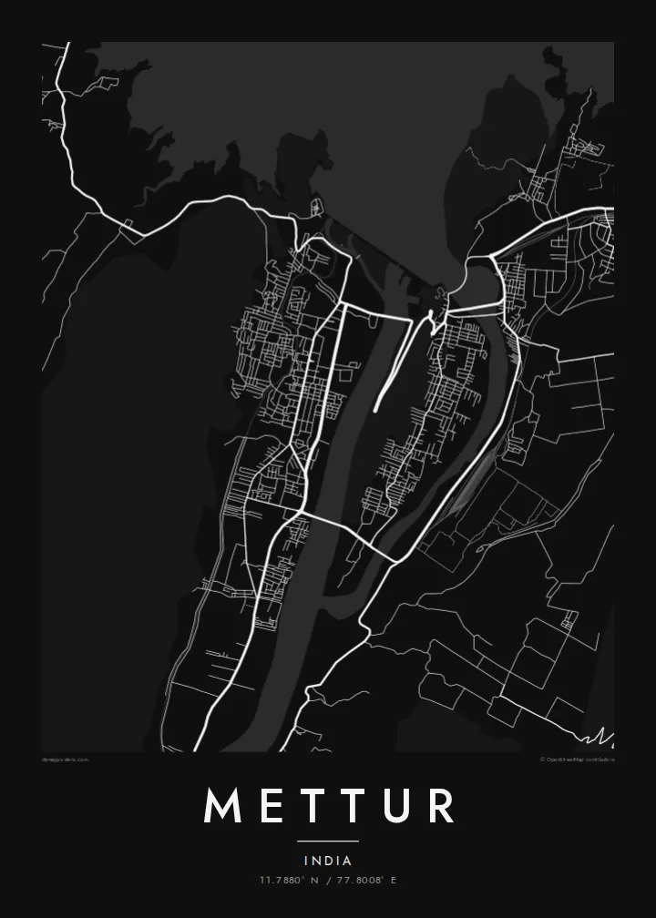
A long masonry dam across the Kaveri, completed in 1934. On the map it is a firm straight line between the reservoir and the town below.
ໂປສເຕີແຜນທີ່ແບບມິນິມອລ · ອິນເດຍ
11.7880° N / 77.8008° E
A town gathered below a long masonry dam, with the broad Stanley Reservoir filling the valley behind it



ເມືອງດຽວ, ຫ້າບັນຍາກາດ
ແຕະເລືອກສະໄຕລ໌ເພື່ອເບິ່ງຢູ່ເທິງຝາ. ທຸກສະໄຕລ໌ລາຄາເທົ່າກັນ — ພິມ, ໃສ່ກອບ ຫຼື ເປັນໄຟລ໌ HD.
 ພິກເຊວຈິງ · ໄຟລ໌ພິມ 24 × 36″
ຄົມຊັດພ້ອມພິມ
ນີ້ແມ່ນພາບຕັດ 100% ຈາກໄຟລ໌ພິມຕົວຈິງ. ໂປສເຕີທຸກໃບ — ພິມ, ໃສ່ກອບ ຫຼື ດາວໂຫຼດ — ຖືກສ້າງຢູ່ເຊີບເວີຂອງພວກເຮົາທີ່ 300 DPI, ສູງເຖິງ 7,200 × 10,800 ພິກເຊວ, ດັ່ງນັ້ນເສັ້ນທາງນ້ອຍທີ່ສຸດກໍ່ຍັງຄົມຊັດເມື່ອພິມຂະໜາດ 24 × 36″.
ຢູ່ເທິງຝາ


ແຜນທີ່
Mettur is built around the Kaveri river where it leaves the hills of Salem district. From above, one structure shapes everything: the long wall of the Mettur Dam, finished in 1934. Behind it the Stanley Reservoir fills the valley in a wide body of water with many fingers. Below it, the town and its industrial areas follow the river downstream.
The dam is one of the oldest large dams in India, and it controls water for irrigation across the Kaveri delta far to the east. Its release dates matter to farmers throughout the region. The streets on the map show how closely the settlement is tied to the dam: roads run along the embankments, and housing sits on the slopes nearby.
A Mettur map poster shows a town defined by engineering. The straight line of the dam divides the smooth expanse of the reservoir from the narrower river channel, and hills on both sides frame the scene. Printed in monochrome, the drawing is almost diagrammatic, like a cross-section of how the Kaveri has been held back and put to work.
A long masonry dam across the Kaveri, completed in 1934. On the map it is a firm straight line between the reservoir and the town below.
The lake behind the dam spreads upstream into branching inlets that follow the old valley, the largest open shape on the poster.
Downstream of the dam the Kaveri narrows again into a single channel, with the town's streets and works along its banks.
ເຮັດໃຫ້ເປັນຂອງທ່ານ
ເພີ່ມວັນທີ, ຊື່ ຫຼື ຂໍ້ຄວາມຂອງທ່ານເອງ, ປ່ຽນສະໄຕລ໌, ຂະໜາດ ຫຼື ທິດທາງ.
ຕົວຢ່າງຟຣີມີຄວາມລະອຽດຕ່ຳ ແລະ ມີລາຍນ້ຳ. ໂປສເຕີພິມ ແລະ ໄຟລ໌ HD ຖືກສ້າງທີ່ 300 DPI, ສູງເຖິງ 7,200 × 10,800 px, ບໍ່ມີລາຍນ້ຳ.
ເປັນຫຍັງຕ້ອງ Mettur
Mettur means a lot to anyone whose family farms on Kaveri water or who grew up near the dam colonies. The poster turns a familiar landmark into a clean composition that people who know the place recognise at once.
Personalise the title, subtitle and coordinates line, and pick one of five styles: Classic black & white, Noir, Paper, Blueprint or Sand. Digital files cost $9 and come in six sizes as 300 DPI PNG and print-ready PDF. Printed posters ship from partners in over 30 countries.
ສັ່ງໂປສເຕີ Mettur| ຂະໜາດພິມ | ຄວາມລະອຽດ | ໄຟລ໌ |
|---|---|---|
| 30 × 40 cm11.8 × 15.7″ | 3,543 × 4,724 px | PNG · PDF |
| 29.7 × 42 cm (A3)11.7 × 16.5″ | 3,508 × 4,961 px | PNG · PDF |
| 42 × 59.4 cm (A2)16.5 × 23.4″ | 4,961 × 7,016 px | PNG · PDF |
| 45.7 × 61 cm18 × 24″ | 5,400 × 7,200 px | PNG · PDF |
| 50 × 70 cm19.7 × 27.6″ | 5,906 × 8,268 px | PNG · PDF |
| 61 × 91.4 cm24 × 36″ | 7,200 × 10,800 px | PNG · PDF |
ເພື່ອປຽບທຽບ, ຕົວຢ່າງຟຣີກວ້າງ 900 px, ມີລາຍນ້ຳ ແລະ ເໝາະສຳລັບໜ້າຈໍ. ໄຟລ໌ HD ມີຄວາມລະອຽດສູງກວ່າເຖິງ 8 ເທົ່າໃນແຕ່ລະດ້ານ ແລະ ພິມອອກມາຄົມຊັດເຕັມຂະໜາດໂປສເຕີ.
ເລືອກສະໄຕລ໌ຢູ່ເທິງສຸດຂອງໜ້າ ຈາກນັ້ນເລືອກ Printed Poster — ຂະໜາດ ແລະ ຖ້າຕ້ອງການ ກອບຮູບ — ຫຼື Digital HD Files. ການຊຳລະເງິນມີພຽງຂັ້ນຕອນດຽວ ແລະ ໜ້າຄຳສັ່ງຊື້ຂອງທ່ານຈະອັບເດດທັນທີທີ່ຊຳລະເງິນສຳເລັດ.
ພິມໃສ່ເຈ້ຍດ້ານພຣີມຽມ 200 gsm ໃນໜຶ່ງໃນຫົກຂະໜາດ, ຈາກ 30 × 40 cm ຫາ 24 × 36″. ໂປສເຕີພິມເລີ່ມຕົ້ນທີ່ $39, ລວມຄ່າສົ່ງ.
ໄດ້. ເລືອກກອບໄມ້ແທ້ສີດຳ, ສີຂາວ, ໄມ້ໂອກທຳມະຊາດ ຫຼື ໄມ້ສີເຂັ້ມ. ມາພ້ອມກະຈົກກັນແຕກ ແລະ ພ້ອມແຂວນໄດ້ທັນທີ. ໂປສເຕີໃສ່ກອບເລີ່ມຕົ້ນທີ່ $99, ລວມຄ່າສົ່ງ.
ຈັດສົ່ງຟຣີໄປ 60+ ປະເທດ. ໂປສເຕີແຕ່ລະອັນຖືກພິມໂດຍຄູ່ຮ່ວມງານພິມທີ່ຢູ່ໃກ້ທີ່ສຸດໃນ 30+ ປະເທດ ແລະ ປົກກະຕິຈະຮອດພາຍໃນ 3–7 ວັນທຳການ. ທ່ານສາມາດຕິດຕາມສະຖານະ ແລະ ເລກພັດສະດຸໄດ້ທີ່ ຄຳສັ່ງຊື້ຂອງຂ້ອຍ. ບາງປະເທດໃຊ້ເວລາ 2–5 ອາທິດ, ແລະ ຖ້າປະເທດໃດທີ່ເຮົາຍັງບໍ່ໄດ້ຈັດສົ່ງໄປ, ເວັບໄຊຈະແຈ້ງໃຫ້ທ່ານຮູ້ກ່ອນຊຳລະເງິນ.
ສົ່ງຮູບຖ່າຍໃຫ້ພວກເຮົາພາຍໃນ 14 ວັນຫຼັງໄດ້ຮັບສິນຄ້າ ແລ້ວພວກເຮົາຈະພິມໃຫ້ໃໝ່ຟຣີ ຫຼື ຄືນເງິນໃຫ້ທ່ານ.
ໄດ້. ໃນຕົວແກ້ໄຂຢູ່ໜ້ານີ້ ປ່ຽນຫົວຂໍ້, ຫົວຂໍ້ຍ່ອຍ ແລະ ແຖວພິກັດເປັນຫຍັງກໍ່ໄດ້ຕາມໃຈມັກ ແລ້ວເລືອກສະໄຕລ໌ ແລະ ຂະໜາດ. ຄຳສັ່ງຊື້ແບບພິມ, ໃສ່ກອບ ແລະ ດິຈິຕອລ ຈະໃຊ້ດີໄຊນ໌ຂອງທ່ານທັງໝົດ.
ໃນລາຄາ $9 ທ່ານຈະໄດ້ຮັບໄຟລ໌ PNG ແລະ PDF ພ້ອມພິມທີ່ 300 DPI ໃນທັງຫົກຂະໜາດ, ບໍ່ມີລາຍນ້ຳ, ພິມທີ່ໃດກໍ່ໄດ້. ຍັງບໍ່ແນ່ໃຈບໍ? ດາວໂຫຼດຕົວຢ່າງທີ່ມີລາຍນ້ຳຟຣີກ່ອນ.
