The Misbourne valley
The River Misbourne runs through the village along the valley floor. It is a narrow chalk stream that sometimes runs low, and it sets the direction the whole settlement stretches in.
Minimālistisks kartes plakāts · Apvienotā Karaliste
51.6088° N / 0.5562° W
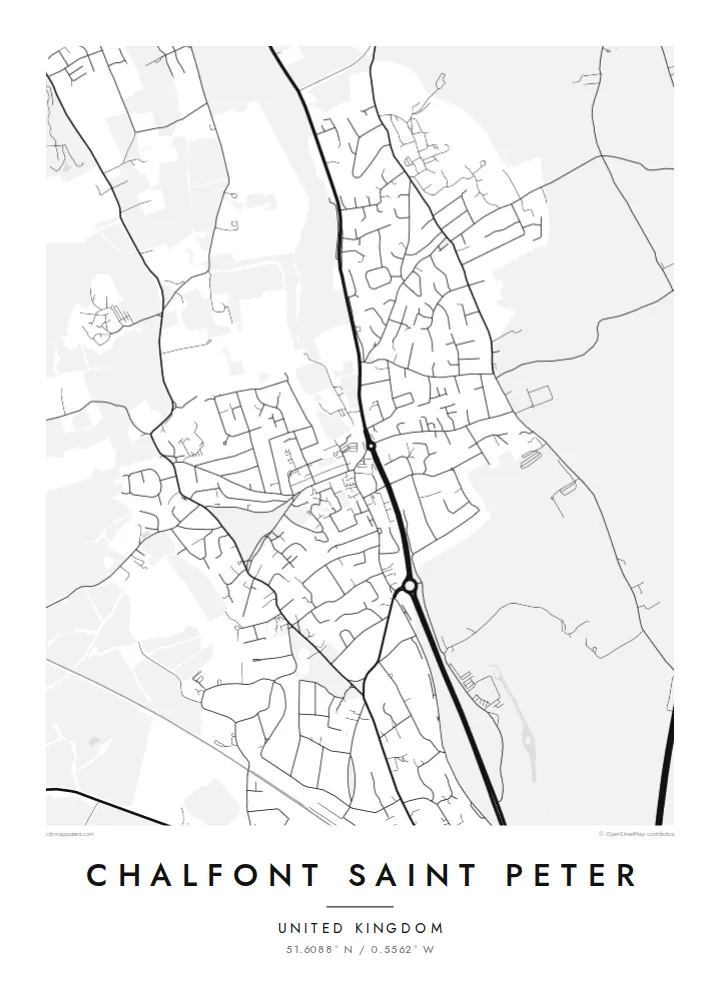
A large Buckinghamshire village drawn along the Misbourne valley, its old centre ringed by curving cul-de-sacs, commons and wooded edges


Viena pilsēta, pieci noskaņojumi
Pieskaries stilam, lai redzētu to uz sienas. Visi stili maksā vienādi — drukāts, ierāmēts vai kā HD faili.
 Reālie pikseļi · 24 × 36″ drukas fails
Asa izdruka
Šis ir 100% izgriezums no reālā drukas faila. Katrs plakāts — drukāts, ierāmēts vai lejupielādēts — tiek renderēts mūsu serveros ar 300 DPI izšķirtspēju, līdz 7,200 × 10,800 pikseļiem, tāpēc pat vismazākās ieliņas paliek asas uz 24 × 36″ izdruka.
Uz sienas


Karte
Seen from above, Chalfont Saint Peter follows the shallow valley of the River Misbourne, a small chalk stream that runs south-east through the Chiltern foothills. The older core sits low beside the water and the main road, and newer housing climbs the slopes on either side. Houses thin out into fields, hedgerows and patches of woodland, so the village keeps a clear outline and never blurs into its neighbours.
The street pattern shows how the place grew. A handful of older roads meet near the village centre. Around them, twentieth-century estates fill the rest of the map with looping crescents, closes and short dead ends, which give the drawing a soft, rounded texture. With around twenty thousand residents, Chalfont Saint Peter is often described as one of the largest villages in England, and the density of lines on the map shows it.
A Chalfont Saint Peter map poster reduces all of this to linework: the thin thread of the Misbourne, the main road through the valley, and open spaces such as Gold Hill Common. Gerrards Cross lies close to the south, and Chalfont St Giles sits further up the valley to the north-west. Printed in monochrome, the map reads as one compact settlement set into the green belt west of London.
The River Misbourne runs through the village along the valley floor. It is a narrow chalk stream that sometimes runs low, and it sets the direction the whole settlement stretches in.
Most of the map is made up of residential estates whose curving roads and closes branch off a few older through-routes. From above they form a dense, rounded pattern.
Open ground such as Gold Hill Common and the surrounding fields and woods break up the housing. On the poster they show as calm blank spaces around the edges of the village.
Padariet to savu
Pievienojiet datumu, vārdu vai savu tekstu, mainiet stilu, izmēru vai orientāciju.
Bezmaksas priekšskatījumam ir zema izšķirtspēja un ūdenszīme. Drukas un HD faili tiek renderēti ar 300 DPI izšķirtspēju, līdz 7,200 × 10,800 px, bez ūdenszīmes.
Kāpēc Chalfont Saint Peter
Chalfont Saint Peter is the kind of place people remember in detail: the walk to school, the road down to the village centre, the common at the weekend. The map keeps those routes in one frame. It suits people who grew up here, families who have just moved in, and anyone who left for London and still thinks of it as home.
You can change the title, subtitle and coordinates line to mark a street, a family name or a meaningful date. There are five styles: Classic black & white, Noir, Paper, Blueprint and Sand. HD files cost $9, and you can also order a matte print, framed if you like, from print partners in more than 30 countries.
Pasūtīt Chalfont Saint Peter plakātu| Drukas izmērs | Izšķirtspēja | Faili |
|---|---|---|
| 30 × 40 cm11.8 × 15.7″ | 3,543 × 4,724 px | PNG · PDF |
| 29.7 × 42 cm (A3)11.7 × 16.5″ | 3,508 × 4,961 px | PNG · PDF |
| 42 × 59.4 cm (A2)16.5 × 23.4″ | 4,961 × 7,016 px | PNG · PDF |
| 45.7 × 61 cm18 × 24″ | 5,400 × 7,200 px | PNG · PDF |
| 50 × 70 cm19.7 × 27.6″ | 5,906 × 8,268 px | PNG · PDF |
| 61 × 91.4 cm24 × 36″ | 7,200 × 10,800 px | PNG · PDF |
Salīdzinājumam: bezmaksas priekšskatījums ir 900 px plats, ar ūdenszīmi un paredzēts ekrāniem. HD failiem ir līdz 8× lielāka izšķirtspēja katrā virzienā, un tie tīri izdrukājas pilnā plakāta izmērā.
Izvēlies stilu lapas augšā, tad izvēlies Drukāts plakāts — izmēru un, ja vēlies, rāmi — vai Digitālie HD faili. Norēķins aizņem vienu soli, un tavas pasūtījuma lapa atjaunojas, tiklīdz maksājums ir veiksmīgs.
Tas tiek drukāts uz augstas kvalitātes 200 g/m² matēta papīra vienā no sešiem izmēriem, sākot no 30 × 40 cm līdz 24 × 36″. Drukāti plakāti maksā jau no $39, piegāde iekļauta.
Jā. Izvēlies masīvkoka rāmi melnā, baltā, dabiskā ozola vai tumša koka tonī. Tas nāk ar necaurlaužamu stiklojumu un ir gatavs pakarināšanai. Ierāmēti plakāti maksā jau no $99, piegāde iekļauta.
Piegāde uz 60+ valstīm ir bezmaksas. Katru plakātu izdrukā tuvākais no mūsu poligrāfijas partneriem 30+ valstīs, un parasti tas pienāk 3–7 darba dienās. Statusu un sūtījuma izsekošanu var redzēt sadaļā “Mani pasūtījumi”. Dažās valstīs piegāde aizņem 2–5 nedēļas, bet, ja uz jūsu valsti vēl nepiegādājam, vietne par to paziņos pirms apmaksas.
Nosūti mums fotoattēlu 14 dienu laikā pēc piegādes, un mēs to bez maksas pārdrukāsim vai atmaksāsim naudu.
Jā. Šīs lapas redaktorā vari mainīt virsrakstu, apakšvirsrakstu un koordinātu rindu pēc savas izvēles, kā arī izvēlēties stilu un izmēru. Drukātie, ierāmētie un digitālie pasūtījumi izmanto tieši tavu dizainu.
Par $9 tu saņem 300 DPI PNG un drukai gatavus PDF failus visos sešos izmēros, bez ūdenszīmes, drukāšanai jebkur. Vēl neesi pārliecināts? Vispirms lejupielādē bezmaksas priekšskatījumu ar ūdenszīmi.
Tuvumā
