Northern settlements
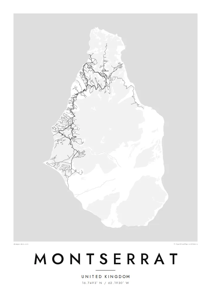
Brades, Little Bay and the surrounding villages gather most of the island's roads in the north, where winding lanes follow the ridges and valleys of the Silver and Centre Hills.
Minimālistisks kartes plakāts · Apvienotā Karaliste
16.7493° N / 62.1930° W
A small, pear-shaped Caribbean island whose green northern hills hold the towns while the volcanic south lies closed.


Viena pilsēta, pieci noskaņojumi
Pieskaries stilam, lai redzētu to uz sienas. Visi stili maksā vienādi — drukāts, ierāmēts vai kā HD faili.
 Reālie pikseļi · 24 × 36″ drukas fails
Asa izdruka
Šis ir 100% izgriezums no reālā drukas faila. Katrs plakāts — drukāts, ierāmēts vai lejupielādēts — tiek renderēts mūsu serveros ar 300 DPI izšķirtspēju, līdz 7,200 × 10,800 pikseļiem, tāpēc pat vismazākās ieliņas paliek asas uz 24 × 36″ izdruka.
Uz sienas


Karte
Montserrat is a British Overseas Territory in the Leeward Islands, around sixteen kilometres from north to south. Its shape narrows toward the north, and three groups of hills run down its length: the Silver Hills at the northern tip, the forested Centre Hills in the middle and the Soufrière Hills in the south. It has long been called the Emerald Isle of the Caribbean, partly for its Irish heritage.
Since 1995 the Soufrière Hills volcano has reshaped the island. Eruptions buried the former capital, Plymouth, and much of the south became an exclusion zone. A Montserrat map poster therefore shows an unusual pattern: roads and villages concentrated in the north, around Brades and Little Bay, and a southern half where the streets of the abandoned capital sit cut off from the rest of the network.
Life on the island moved north after the eruptions, and a new airport, new housing and a small port were built there. The volcano is still monitored closely, and the landscape around it continues to change with each period of activity. The result on paper is a map that records both an island and a recent turn in its history.
Brades, Little Bay and the surrounding villages gather most of the island's roads in the north, where winding lanes follow the ridges and valleys of the Silver and Centre Hills.
The volcano dominates the southern half, its slopes left largely without roads. On the poster this area reads as open ground, a clear graphic contrast with the settled north.
The former capital on the southwest coast was abandoned after the 1997 eruptions. Its street pattern still shows on the map, isolated inside the exclusion zone.
Padariet to savu
Pievienojiet datumu, vārdu vai savu tekstu, mainiet stilu, izmēru vai orientāciju.
Bezmaksas priekšskatījumam ir zema izšķirtspēja un ūdenszīme. Drukas un HD faili tiek renderēti ar 300 DPI izšķirtspēju, līdz 7,200 × 10,800 px, bez ūdenszīmes.
Kāpēc Montserrat
People with family ties to Montserrat, and those who knew it before 1995, often want a map that shows the whole island rather than only its settled part. The compact outline fits comfortably on any of the print sizes and keeps its detail.
The title, subtitle and coordinates line can all be changed, so the poster might carry a family village or a year that matters. Pick one of five styles, Classic, Noir, Paper, Blueprint or Sand, then download 300 DPI files for $9 or order a printed poster with an optional wooden frame.
Pasūtīt Montserrat plakātu| Drukas izmērs | Izšķirtspēja | Faili |
|---|---|---|
| 30 × 40 cm11.8 × 15.7″ | 3,543 × 4,724 px | PNG · PDF |
| 29.7 × 42 cm (A3)11.7 × 16.5″ | 3,508 × 4,961 px | PNG · PDF |
| 42 × 59.4 cm (A2)16.5 × 23.4″ | 4,961 × 7,016 px | PNG · PDF |
| 45.7 × 61 cm18 × 24″ | 5,400 × 7,200 px | PNG · PDF |
| 50 × 70 cm19.7 × 27.6″ | 5,906 × 8,268 px | PNG · PDF |
| 61 × 91.4 cm24 × 36″ | 7,200 × 10,800 px | PNG · PDF |
Salīdzinājumam: bezmaksas priekšskatījums ir 900 px plats, ar ūdenszīmi un paredzēts ekrāniem. HD failiem ir līdz 8× lielāka izšķirtspēja katrā virzienā, un tie tīri izdrukājas pilnā plakāta izmērā.
Izvēlies stilu lapas augšā, tad izvēlies Drukāts plakāts — izmēru un, ja vēlies, rāmi — vai Digitālie HD faili. Norēķins aizņem vienu soli, un tavas pasūtījuma lapa atjaunojas, tiklīdz maksājums ir veiksmīgs.
Tas tiek drukāts uz augstas kvalitātes 200 g/m² matēta papīra vienā no sešiem izmēriem, sākot no 30 × 40 cm līdz 24 × 36″. Drukāti plakāti maksā jau no $39, piegāde iekļauta.
Jā. Izvēlies masīvkoka rāmi melnā, baltā, dabiskā ozola vai tumša koka tonī. Tas nāk ar necaurlaužamu stiklojumu un ir gatavs pakarināšanai. Ierāmēti plakāti maksā jau no $99, piegāde iekļauta.
Piegāde uz 60+ valstīm ir bezmaksas. Katru plakātu izdrukā tuvākais no mūsu poligrāfijas partneriem 30+ valstīs, un parasti tas pienāk 3–7 darba dienās. Statusu un sūtījuma izsekošanu var redzēt sadaļā “Mani pasūtījumi”. Dažās valstīs piegāde aizņem 2–5 nedēļas, bet, ja uz jūsu valsti vēl nepiegādājam, vietne par to paziņos pirms apmaksas.
Nosūti mums fotoattēlu 14 dienu laikā pēc piegādes, un mēs to bez maksas pārdrukāsim vai atmaksāsim naudu.
Jā. Šīs lapas redaktorā vari mainīt virsrakstu, apakšvirsrakstu un koordinātu rindu pēc savas izvēles, kā arī izvēlēties stilu un izmēru. Drukātie, ierāmētie un digitālie pasūtījumi izmanto tieši tavu dizainu.
Par $9 tu saņem 300 DPI PNG un drukai gatavus PDF failus visos sešos izmēros, bez ūdenszīmes, drukāšanai jebkur. Vēl neesi pārliecināts? Vispirms lejupielādē bezmaksas priekšskatījumu ar ūdenszīmi.
