Border town
The Nepal–India boundary lies at the southern edge of Gaur, and the neighbouring Indian town is close enough that the two settlements nearly meet on the map.
Poster in mab ejjab eļap an kōkaan · Nepal
26.7637° N / 85.2766° E
A district headquarters on Nepal's Terai plain, built right up to the Indian border, with flat farmland in every direction.



Juon jikin kweilok, ļalem eñjake
Jibburi juon style ñan lo e ilo wall. Aolep style ej jokutok wōt āinwōt juon — mede, likūt ilo frame ak ñan bōk āinwōt HD files.
 Pixels eo eṃool · 24 × 36″ file in mede
Alikkar ñan prin
Menin juon crop 100% jān file in mede eo eṃool. Aolep poster — meej, likūt ilo frame ak load — rej kōṃṃane ilo server ko am ilo 300 DPI, ñan 7,200 × 10,800 pixel, bwe lanes ko re dik wōt rej pād im alikkar ilo mede eo 24 × 36″.
Ioon kiin


Mab eo
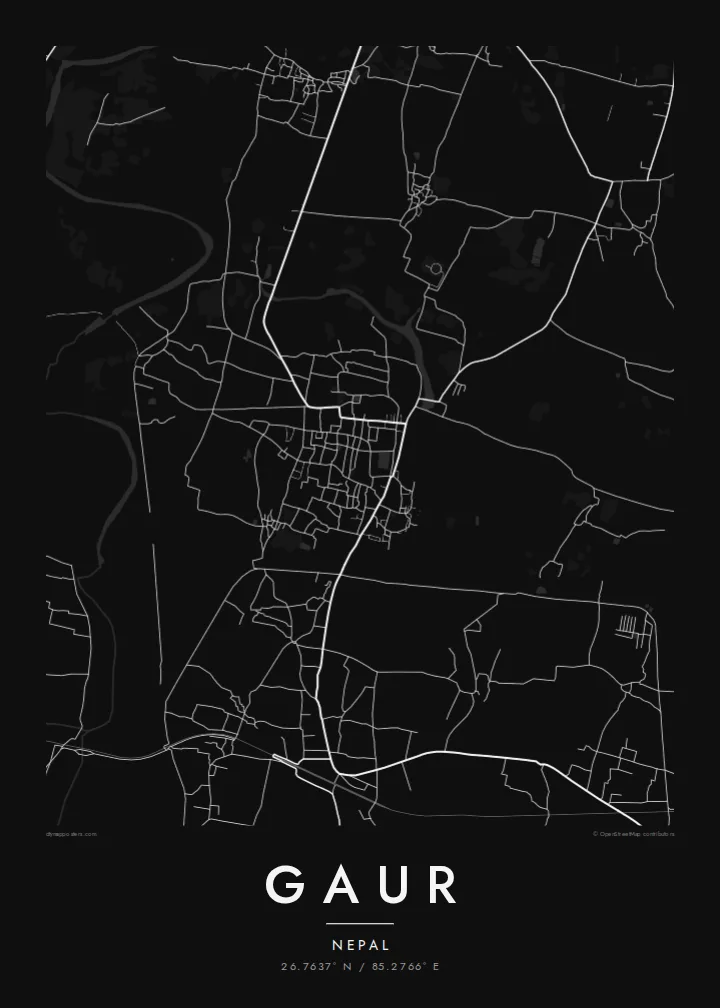
Gaur is the headquarters of Rautahat District in Madhesh Province, in the flat Terai lowlands of southern Nepal. The town sits directly on the border with the Indian state of Bihar. On the map the boundary runs along its southern edge, with the town of Bairgania close by on the Indian side, and that closeness defines the place.
The land around Gaur is almost perfectly flat, part of the great Gangetic plain. Rivers flowing down from the hills to the north cross the district in broad, shifting channels, and the countryside is a dense pattern of fields, ponds and villages linked by narrow roads. The town's own streets form a compact core, with markets and government offices at its centre.
A Gaur map poster shows the Terai as it looks from above: a fine, even texture of farmland and settlements, broken by river courses and by the line of the international border. In black and white the effect is calm and precise, a portrait of an ordinary but important town on one of South Asia's most open borders.
The Nepal–India boundary lies at the southern edge of Gaur, and the neighbouring Indian town is close enough that the two settlements nearly meet on the map.
Rivers draining the hills to the north cross the plain in wide, braided courses, adding sweeping lines to an otherwise flat, finely divided landscape.
Small ponds, field plots and village clusters fill the countryside, giving the Terai its characteristic dotted, patterned appearance in black and white.
Kōmmane bwe en aṃ
Kōbaiki juon raan, juon etan ak juon naan eo aṃ, ukōt wāween, joñan ak ooj.
Preview eo ejjeḷọk oṇāān ej resolution edik im ewor watermark. Poster ko rej mede im HD files rej kōṃṃane ilo 300 DPI, ñan 7,200 × 10,800 px, ejjeḷọk watermark.
Etke Gaur
People from Rautahat often live and work far from home, in Kathmandu, in India or in the Gulf. A map of Gaur brings back the streets, markets and fields of the district headquarters in a single image.
Write your own title, add a subtitle and edit the coordinates line, then pick Classic black & white, Noir, Paper, Blueprint or Sand. A free 900 px preview is available before you buy the $9 HD files.
Order poster Gaur| Joñan prin | Resolution | File ko |
|---|---|---|
| 30 × 40 cm (11.8 × 15.7″) | 3,543 × 4,724 px | PNG · PDF |
| 29.7 × 42 cm (A3, 11.7 × 16.5″) | 3,508 × 4,961 px | PNG · PDF |
| 42 × 59.4 cm (A2, 16.5 × 23.4″) | 4,961 × 7,016 px | PNG · PDF |
| 45.7 × 61 cm (18 × 24″) | 5,400 × 7,200 px | PNG · PDF |
| 50 × 70 cm (19.7 × 27.6″) | 5,906 × 8,268 px | PNG · PDF |
| 61 × 91.4 cm (24 × 36″) | 7,200 × 10,800 px | PNG · PDF |
Ñan keidi, preview eo ejjeļọk wōnāān ej 900 px an depakpak, ewōr watermark im ej ñan screen wōt. File HD ko rej ñan 8× an alikkar ilo aolep tu im rej prin emmanḷọk ilo joñan poster eo aolepen.
Kāālōt juon style i tōp in page eo, innām kāālōt Poster eṃōj Mede — juon size im, eḷaññe kwōj kōṇaan, juon frame — ak Digital HD Files. Checkout ej juon wōt buñtōn, im page in order eo aṃ enaaj kāāl ñe payment eo ej dedeḷọk.
Emej ilo bok premium 200 gsm matte, ilo juon iaan jiljino size, jān 30 × 40 cm ñan 24 × 36″. Poster ko rej mede rej jino jān $39, jipañ in kadikdik ej pād ilo wōt.
Aet. Kāālōt juon frame wōjke pen ilo black, white, oak ereo ak wōjke marok. Ej itok ippān kilaj ejjab bwilọk im pojak ñan totouk. Poster ko ilo frame rej jino jān $99, jipañ in kadikdik ej pād ilo wōt.
Jipiñ ejjeḷọk wōṇāān ilo lal otemjej. Poster ko otemjej renaaj pritin ko ilo jikin pritin eo ekāāl eo ippān jikin pritin ro jemaṇ ilo 30+ aelōñ̄ ko, im ekkā renaaj tōpar ilo 3–7 raan ko ñan jerbal. Kwōmaroñ lale tōprak im tracking ilo My Orders. Jet aelōñ̄ ko renaaj bwe 2–5 wiik, im ilo jikin ko jemaṇ jipiñ ṇae, site in ej ba ñan eok mokta jān am pāyiṇ.
Jilkinwōj juon pija ilowaan 14 raan jān an itok, im kōmnaaj mede juon alen ejjeḷọk oṇāān ak kōṃṃan refund ñan eok.
Aet. Ilo editor eo ilo page in, ukōt title eo, subtitle eo im coordinates ñan jabdewōt kwōj kōṇaan, im kāālōt juon style im size. Order ko mede, ilo frame im digital rej kōjerbal wōt design eo aṃ eṃool.
Kōn $9 kwōj bōk 300 DPI PNG im PDF files pojak ñan mede ilo aolep jiljino size, ejjeḷọk watermark, ñan mede ijoko jabdewōt. Ejjañin lukkuun alikkar ippaṃ? Load juon preview eo ejjeḷọk oṇāān kōn watermark ṃokta.
Ekkepaake
