Genoese fort island
A rocky island topped with a Genoese fort sits just offshore. It shows on the map as a bold, separate shape beside the harbour.
Poster in mab ejjab eļap an kōkaan · Tunisia
36.9544° N / 8.7580° E
A small port town on Tunisia's north coast, with a Genoese fort on a rocky island joined by a causeway


Juon jikin kweilok, ļalem eñjake
Jibburi juon style ñan lo e ilo wall. Aolep style ej jokutok wōt āinwōt juon — mede, likūt ilo frame ak ñan bōk āinwōt HD files.
 Pixels eo eṃool · 24 × 36″ file in mede
Alikkar ñan prin
Menin juon crop 100% jān file in mede eo eṃool. Aolep poster — meej, likūt ilo frame ak load — rej kōṃṃane ilo server ko am ilo 300 DPI, ñan 7,200 × 10,800 pixel, bwe lanes ko re dik wōt rej pād im alikkar ilo mede eo 24 × 36″.
Ioon kiin


Mab eo
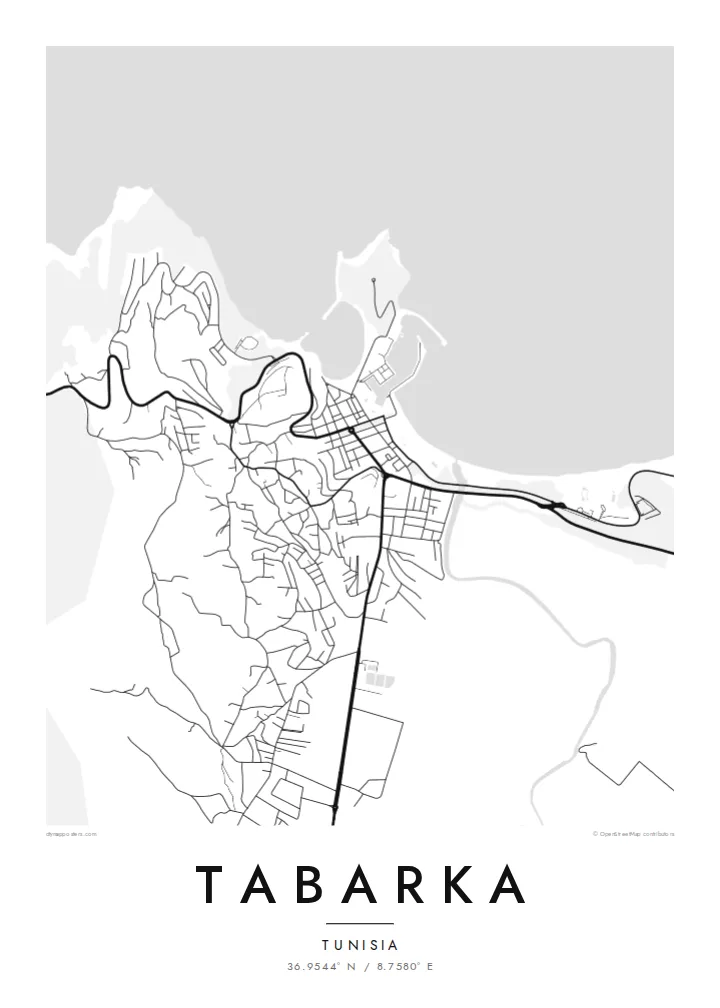
Tabarka lies on the north-western coast of Tunisia, close to the Algerian border. Here the forested Kroumirie hills come down to the Mediterranean. On a map, the town wraps around a small bay and harbour. Just offshore sits a rocky island crowned by a fort built by the Genoese, who held it for coral fishing from the sixteenth century.
The island is joined to the mainland by a narrow causeway. Along the coast west of the harbour stand the Aiguilles, tall sea-worn rock needles that are one of the town's best-known sights. Tabarka is also known for coral diving, for the cork oak forests inland and for the music festivals held here in summer.
A Tabarka map poster is shaped by the coastline: the bay, the causeway, the island and the rocky shore beyond. It is a composition full of distinct shapes. The Sand and Paper styles suit the Mediterranean setting, while Noir sets the white coastline sharply against dark water.
A rocky island topped with a Genoese fort sits just offshore. It shows on the map as a bold, separate shape beside the harbour.
A narrow causeway links the island to the town. It draws a thin, direct line across the water that is easy to pick out.
West of the harbour, tall rock needles known as the Aiguilles line the shore. They mark one of the most recognisable stretches of coast.
Kōmmane bwe en aṃ
Kōbaiki juon raan, juon etan ak juon naan eo aṃ, ukōt wāween, joñan ak ooj.
Preview eo ejjeḷọk oṇāān ej resolution edik im ewor watermark. Poster ko rej mede im HD files rej kōṃṃane ilo 300 DPI, ñan 7,200 × 10,800 px, ejjeḷọk watermark.
Etke Tabarka
Tabarka is a place people return to: for diving, for festivals, or simply for the quiet of a small coastal town. A map of the bay and fort keeps that setting in view long after the trip is over.
Add your own title and subtitle, for example a year or a name, and keep the coordinates line. Then choose Classic black & white, Noir, Paper, Blueprint or Sand. Sand works especially well with this coast.
Order poster Tabarka| Joñan prin | Resolution | File ko |
|---|---|---|
| 30 × 40 cm11.8 × 15.7″ | 3,543 × 4,724 px | PNG · PDF |
| 29.7 × 42 cm (A3)11.7 × 16.5″ | 3,508 × 4,961 px | PNG · PDF |
| 42 × 59.4 cm (A2)16.5 × 23.4″ | 4,961 × 7,016 px | PNG · PDF |
| 45.7 × 61 cm18 × 24″ | 5,400 × 7,200 px | PNG · PDF |
| 50 × 70 cm19.7 × 27.6″ | 5,906 × 8,268 px | PNG · PDF |
| 61 × 91.4 cm24 × 36″ | 7,200 × 10,800 px | PNG · PDF |
Ñan keidi, preview eo ejjeļọk wōnāān ej 900 px an depakpak, ewōr watermark im ej ñan screen wōt. File HD ko rej ñan 8× an alikkar ilo aolep tu im rej prin emmanḷọk ilo joñan poster eo aolepen.
Kāālōt juon style i tōp in page eo, innām kāālōt Poster eṃōj Mede — juon size im, eḷaññe kwōj kōṇaan, juon frame — ak Digital HD Files. Checkout ej juon wōt buñtōn, im page in order eo aṃ enaaj kāāl ñe payment eo ej dedeḷọk.
Emej ilo bok premium 200 gsm matte, ilo juon iaan jiljino size, jān 30 × 40 cm ñan 24 × 36″. Poster ko rej mede rej jino jān $39, jipañ in kadikdik ej pād ilo wōt.
Aet. Kāālōt juon frame wōjke pen ilo black, white, oak ereo ak wōjke marok. Ej itok ippān kilaj ejjab bwilọk im pojak ñan totouk. Poster ko ilo frame rej jino jān $99, jipañ in kadikdik ej pād ilo wōt.
Jāntōn ejjeļo̧k̦ ñan āeļōn̄ ko 60+. Kajjojo poster ej pãleejeḷ ilo juon ian ro jet rejjar bwe ren pãleejeḷ ilo āeļōn̄ ko 30+, im ekkã an tōpar ilo raan ko 3–7 an jerbal. Kwomaroñ lale wāween im tracking ilo My Orders. Jet āeļōn̄ rej aikuj 2–5 wiik, im ijoko jejjeļo̧k̦ ñan jāgià, ļaiboro̧ ej ba ñan eok mokta jān am pay.
Jilkinwōj juon pija ilowaan 14 raan jān an itok, im kōmnaaj mede juon alen ejjeḷọk oṇāān ak kōṃṃan refund ñan eok.
Aet. Ilo editor eo ilo page in, ukōt title eo, subtitle eo im coordinates ñan jabdewōt kwōj kōṇaan, im kāālōt juon style im size. Order ko mede, ilo frame im digital rej kōjerbal wōt design eo aṃ eṃool.
Kōn $9 kwōj bōk 300 DPI PNG im PDF files pojak ñan mede ilo aolep jiljino size, ejjeḷọk watermark, ñan mede ijoko jabdewōt. Ejjañin lukkuun alikkar ippaṃ? Load juon preview eo ejjeḷọk oṇāān kōn watermark ṃokta.
Ekkepaake
