Marine Parade
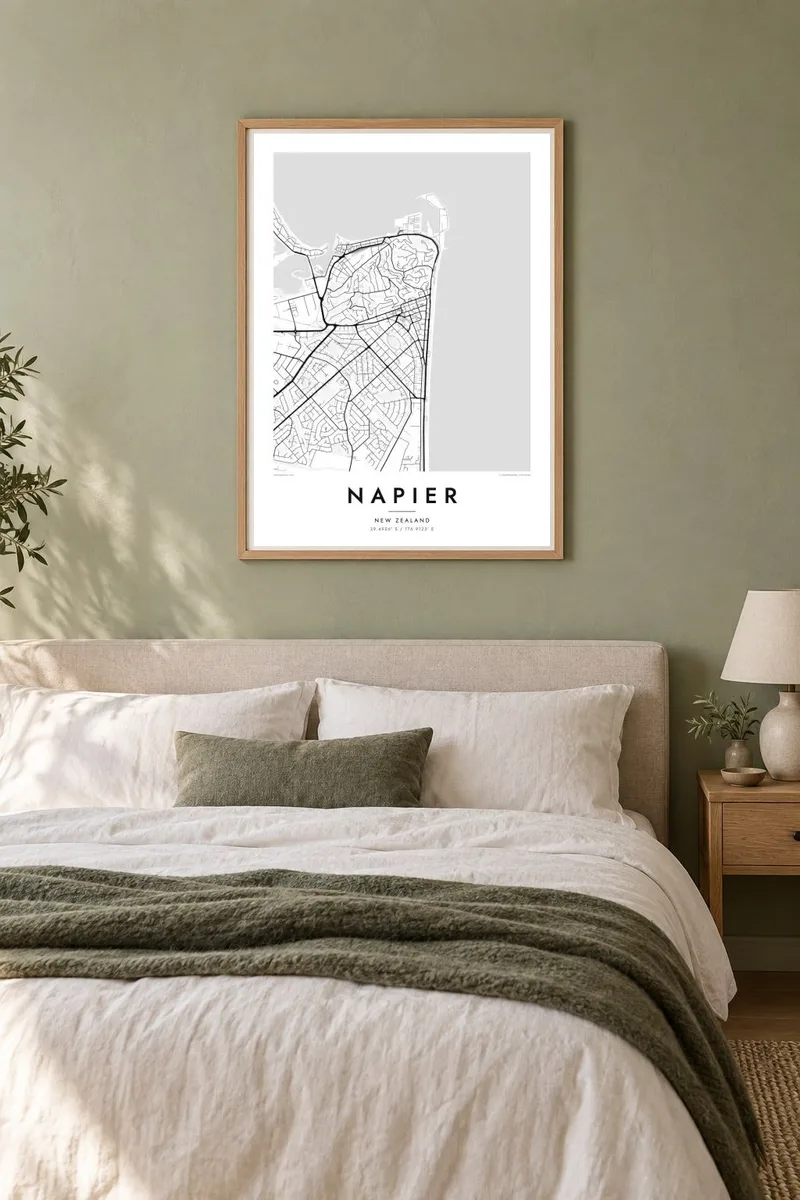
A long seafront road follows the curve of Hawke Bay. On the poster it is a clean, gently curved line between the city and open water.
Poster peta minimalis · New Zealand
39.4926° S / 176.9123° E
An Art Deco city on Hawke Bay, stretched along a long seafront below Bluff Hill and over uplifted land


Satu bandar, lima suasana
Ketik gaya untuk melihatnya di dinding. Setiap gaya harganya sama — dicetak, dibingkai atau sebagai fail HD.
 Piksel sebenar · fail cetakan 24 × 36″
Tajam untuk cetakan
Ini ialah potongan 100% daripada fail cetakan sebenar. Setiap poster — dicetak, dibingkai atau dimuat turun — dijana di pelayan kami pada 300 DPI, sehingga 7,200 × 10,800 piksel, jadi lorong sekecil mana pun kekal tajam pada cetakan 24 × 36″.
Di dinding


Peta
Napier sits on the curve of Hawke Bay on the east coast of New Zealand's North Island. Its map is unusual because part of the land it stands on was once underwater. The 1931 Hawke's Bay earthquake raised the seabed and the Ahuriri Lagoon by several metres, and the city later spread across the new ground, which explains the flat, regular suburbs to the west and south.
The centre was rebuilt after the earthquake and the fires that followed, mostly in Art Deco style, and it forms a compact grid close to the sea. Marine Parade runs along the waterfront, lined with Norfolk pines. To the north, Bluff Hill rises steeply, with winding streets on its slopes and the port of Ahuriri beyond, looking out to the bay.
Today Napier is often described as one of the best-preserved Art Deco towns in the world, and it celebrates that heritage every year. A Napier map poster shows how the city's shape came from one event: a hill, a rebuilt grid, a long seafront and land that was sea less than a hundred years ago.
A long seafront road follows the curve of Hawke Bay. On the poster it is a clean, gently curved line between the city and open water.
The hill north of the centre has winding streets that trace its contours. It is the most irregular, textured part of the map.
Flat suburbs to the west stand on ground uplifted in 1931. Their straight, orderly streets show clearly where the old lagoon once was.
Jadikan milik anda
Tambah tarikh, nama atau ayat anda sendiri, tukar gaya, saiz atau orientasi.
Pratonton percuma beresolusi rendah dengan tanda air. Cetakan dan fail HD dijana pada 300 DPI, sehingga 7,200 × 10,800 px, tanpa tanda air.
Kenapa Napier
Napier appeals to Art Deco fans, to people from Hawke's Bay, and to anyone who has walked along the Marine Parade. The combination of seafront, hill and reclaimed land makes for a distinctive composition.
You can personalise the title and subtitle, for example with a wedding date or an address, and edit the coordinates line. Choose from five styles: Classic black and white, Noir, Paper, Blueprint or Sand.
Tempah poster Napier| Saiz cetakan | Resolusi | Fail |
|---|---|---|
| 30 × 40 cm11.8 × 15.7″ | 3,543 × 4,724 px | PNG · PDF |
| 29.7 × 42 cm (A3)11.7 × 16.5″ | 3,508 × 4,961 px | PNG · PDF |
| 42 × 59.4 cm (A2)16.5 × 23.4″ | 4,961 × 7,016 px | PNG · PDF |
| 45.7 × 61 cm18 × 24″ | 5,400 × 7,200 px | PNG · PDF |
| 50 × 70 cm19.7 × 27.6″ | 5,906 × 8,268 px | PNG · PDF |
| 61 × 91.4 cm24 × 36″ | 7,200 × 10,800 px | PNG · PDF |
Sebagai perbandingan, pratonton percuma selebar 900 px, bertera air dan untuk skrin sahaja. Fail HD mempunyai resolusi sehingga 8× ganda pada setiap arah dan dicetak dengan kemas pada saiz poster penuh.
Pilih gaya di bahagian atas halaman, kemudian pilih Poster Cetakan — saiz dan, jika mahu, bingkai — atau Fail Digital HD. Pembayaran hanya satu langkah, dan halaman pesanan anda akan dikemas kini sebaik sahaja pembayaran selesai.
Ia dicetak pada kertas matte premium 200 gsm dalam salah satu daripada enam saiz, dari 30 × 40 cm hingga 24 × 36″. Poster cetakan bermula pada $39, penghantaran percuma.
Boleh. Pilih bingkai kayu pejal dalam warna hitam, putih, oak semula jadi atau kayu gelap. Ia dilengkapi kaca tahan pecah dan sedia untuk digantung. Poster berbingkai bermula pada $99, penghantaran percuma.
Penghantaran adalah percuma ke 60+ negara. Setiap poster dicetak oleh rakan pencetakan kami yang paling hampir di 30+ negara dan biasanya tiba dalam 3–7 hari bekerja. Anda boleh menjejaki status dan penjejakan di bawah Pesanan Saya. Beberapa negara mengambil masa 2–5 minggu, dan jika kami belum menghantar ke sana, laman web akan memberitahu anda sebelum anda membayar.
Hantarkan kami gambar dalam masa 14 hari selepas penghantaran dan kami akan mencetak semula secara percuma atau memberikan bayaran balik.
Boleh. Dalam editor di halaman ini, ubah tajuk, subtajuk dan baris koordinat mengikut kehendak anda, kemudian pilih gaya dan saiz. Pesanan cetakan, berbingkai dan digital semuanya menggunakan reka bentuk anda dengan tepat.
Dengan harga $9, anda dapat fail PNG 300 DPI dan PDF sedia cetak dalam kesemua enam saiz, tanpa tanda air, untuk dicetak di mana-mana sahaja. Belum pasti? Muat turun pratonton percuma bertanda air dahulu.
