Promenade des Anglais
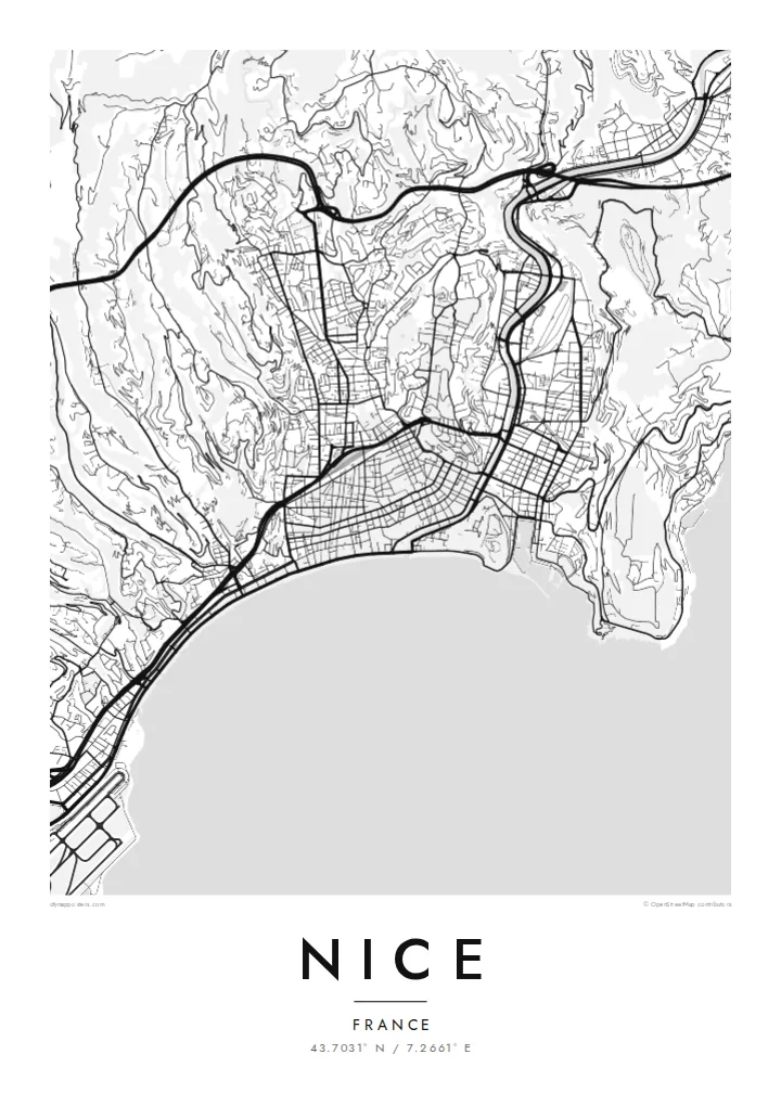
The seafront boulevard follows the Baie des Anges for several kilometres, drawing the city's defining curve from the airport to the foot of Castle Hill.
Poster peta minimalis · Perancis
43.7031° N / 7.2661° E
A curved bay on the Riviera, with the Promenade des Anglais, a tight old town and hills climbing behind


Satu bandar, lima suasana
Ketik gaya untuk melihatnya di dinding. Setiap gaya harganya sama — dicetak, dibingkai atau sebagai fail HD.
 Piksel sebenar · fail cetakan 24 × 36″
Tajam untuk cetakan
Ini ialah potongan 100% daripada fail cetakan sebenar. Setiap poster — dicetak, dibingkai atau dimuat turun — dijana di pelayan kami pada 300 DPI, sehingga 7,200 × 10,800 piksel, jadi lorong sekecil mana pun kekal tajam pada cetakan 24 × 36″.
Di dinding


Peta
Nice lies on the Baie des Anges, the Bay of Angels, on France's Mediterranean coast near the Italian border. Its map opens with one of the most recognisable waterfronts in Europe: the Promenade des Anglais, following the pebbled shore in a long, gentle curve from the airport towards the old town. Behind it the city climbs into hills of villas and winding roads.
At the eastern end of the bay, Vieux Nice packs narrow lanes into a dense triangle below Castle Hill, the rocky promontory that separates the old town from the port. The Paillon river, now covered, runs beneath a long green promenade that divides the old quarter from the nineteenth-century city with its broad streets and squares.
On the hill of Cimiez stand Roman remains and the Matisse Museum, and in 2021 Nice was added to UNESCO's World Heritage List as the winter resort town of the Riviera. A Nice map poster shows how clearly these layers fit together: the bay, the old town, the port, the green line of the Paillon and the hills above.
The seafront boulevard follows the Baie des Anges for several kilometres, drawing the city's defining curve from the airport to the foot of Castle Hill.
The old town's narrow, closely packed lanes create the densest texture on the map, a triangle of streets pressed between the sea, Castle Hill and the Paillon promenade.
East of Castle Hill the harbour forms a neat, nearly rectangular basin cut into the coast, surrounded by streets that slope up towards the hills.
Jadikan milik anda
Tambah tarikh, nama atau ayat anda sendiri, tukar gaya, saiz atau orientasi.
Pratonton percuma beresolusi rendah dengan tanda air. Cetakan dan fail HD dijana pada 300 DPI, sehingga 7,200 × 10,800 px, tanpa tanda air.
Kenapa Nice
Nice is a city of holidays, long stays and new beginnings, loved by residents and visitors alike. Its map, with the sweep of the bay and the dense old town, makes a graceful reminder of a summer, a honeymoon or a first apartment by the sea.
Personalise the title, subtitle and coordinates line, and choose Classic black & white, Noir, Paper, Blueprint or Sand. Download HD files for $9, or order a matte printed poster from partners in 30+ countries, with an optional wooden frame.
Tempah poster Nice| Saiz cetakan | Resolusi | Fail |
|---|---|---|
| 30 × 40 cm (11.8 × 15.7″) | 3,543 × 4,724 px | PNG · PDF |
| 29.7 × 42 cm (A3, 11.7 × 16.5″) | 3,508 × 4,961 px | PNG · PDF |
| 42 × 59.4 cm (A2, 16.5 × 23.4″) | 4,961 × 7,016 px | PNG · PDF |
| 45.7 × 61 cm (18 × 24″) | 5,400 × 7,200 px | PNG · PDF |
| 50 × 70 cm (19.7 × 27.6″) | 5,906 × 8,268 px | PNG · PDF |
| 61 × 91.4 cm (24 × 36″) | 7,200 × 10,800 px | PNG · PDF |
Sebagai perbandingan, pratonton percuma selebar 900 px, bertera air dan untuk skrin sahaja. Fail HD mempunyai resolusi sehingga 8× ganda pada setiap arah dan dicetak dengan kemas pada saiz poster penuh.
Pilih gaya di bahagian atas halaman, kemudian pilih Poster Cetakan — saiz dan, jika mahu, bingkai — atau Fail Digital HD. Pembayaran hanya satu langkah, dan halaman pesanan anda akan dikemas kini sebaik sahaja pembayaran selesai.
Ia dicetak pada kertas matte premium 200 gsm dalam salah satu daripada enam saiz, dari 30 × 40 cm hingga 24 × 36″. Poster cetakan bermula pada {printFrom}, penghantaran percuma.
Boleh. Pilih bingkai kayu pejal dalam warna hitam, putih, oak semula jadi atau kayu gelap. Ia dilengkapi kaca tahan pecah dan sedia untuk digantung. Poster berbingkai bermula pada {framedFrom}, penghantaran percuma.
Penghantaran percuma ke seluruh dunia. Setiap poster dicetak oleh rakan cetakan kami yang paling dekat di lebih 30 negara dan biasanya tiba dalam 3–7 hari bekerja. Anda boleh menyemak status dan penjejakan di bawah Pesanan Saya.
Hantarkan kami gambar dalam masa 14 hari selepas penghantaran dan kami akan mencetak semula secara percuma atau memberikan bayaran balik.
Boleh. Dalam editor di halaman ini, ubah tajuk, subtajuk dan baris koordinat mengikut kehendak anda, kemudian pilih gaya dan saiz. Pesanan cetakan, berbingkai dan digital semuanya menggunakan reka bentuk anda dengan tepat.
Dengan harga $9, anda dapat fail PNG 300 DPI dan PDF sedia cetak dalam kesemua enam saiz, tanpa tanda air, untuk dicetak di mana-mana sahaja. Belum pasti? Muat turun pratonton percuma bertanda air dahulu.
