Central street grid
The core follows a regular grid of rectangular blocks, a layout common to Guatemalan towns. On paper it forms a steady, even texture at the centre of the composition.
मिनिमलिस्ट नक्सा पोस्टर · ग्वाटेमाला
14.3010° N / 90.7882° W
A lowland grid on Guatemala's Pacific slope, strung along the highway that runs from the volcanoes down to the coast



एउटै शहर, पाँच मुड
पर्खालमा कस्तो देखिन्छ हेर्न कुनै स्टाइल छान्नुहोस्। हरेक स्टाइलको मूल्य उस्तै हुन्छ — प्रिन्ट, फ्रेम वा HD फाइलको रूपमा।
 वास्तविक पिक्सेल · 24 × 36″ प्रिन्ट फाइल
प्रिन्टमा प्रस्ट
यो वास्तविक प्रिन्ट फाइलको 100% क्रप हो। हरेक पोस्टर — प्रिन्ट, फ्रेम वा डाउनलोड — हाम्रो सर्भरमा 300 DPI मा, 7,200 × 10,800 पिक्सेलसम्म रेन्डर हुन्छ, त्यसैले सबैभन्दा साना गल्लीहरू पनि 24 × 36″ प्रिन्टमा स्पष्ट देखिन्छन्।
भित्तामा


नक्सा
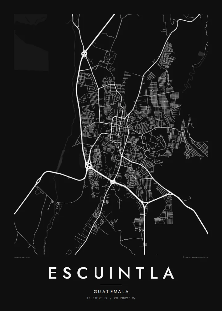
Escuintla lies south of Guatemala City, where the highlands drop into the hot Pacific coastal plain. The city is the capital of the department of the same name. From above it is a fairly regular grid of blocks, cut through by the main highway that links the capital with the Pacific ports. Beyond the edges, the grid gives way to large agricultural estates.
The surrounding lowlands are among the country's most productive farmland, with sugar cane covering much of the plain. To the north the land rises towards the volcanic chain that includes Agua, Fuego and Pacaya. The city sits at the transition between the steep volcanic slopes and the flat coast.
An Escuintla map poster captures this crossroads position. Straight blocks make an even pattern at the centre, while arterial roads leave the grid at angles, heading towards the mountains and the sea. In monochrome, the density of streets and the openness of the surrounding plain are both easy to read.
The core follows a regular grid of rectangular blocks, a layout common to Guatemalan towns. On paper it forms a steady, even texture at the centre of the composition.
The main route between Guatemala City and the Pacific coast runs past the city. It makes a long, confident line that shows Escuintla's role as a stop between highlands and sea.
Beyond the last streets the map opens into broad, sparsely drawn farmland. This gives the dense urban grid a clear outline and plenty of breathing space.
आफ्नै बनाउनुहोस्
मिति, नाम वा आफ्नै एक लाइन थप्नुहोस्, शैली, साइज वा दिशा बदल्नुहोस्।
नि:शुल्क प्रिभ्यू कम-रिजोलुसन र वाटरमार्कसहित हुन्छ। प्रिन्ट र HD फाइलहरू 300 DPI मा, 7,200 × 10,800 px सम्म, वाटरमार्क बिना रेन्डर गरिन्छन्।
किन Escuintla
For anyone with roots in the Pacific lowlands, or who has passed through on the road to the coast, Escuintla's grid is a familiar shape. The poster turns that everyday geography into a quiet piece for a wall.
Add a personal title, a subtitle such as a date or a family name, and your own coordinates line. Then pick Classic black & white, Noir, Paper, Blueprint or Sand to set the mood.
Escuintla पोस्टर अर्डर गर्नुहोस्| प्रिन्ट साइज | रिजोल्युसन | फाइलहरू |
|---|---|---|
| 30 × 40 cm (11.8 × 15.7″) | 3,543 × 4,724 px | PNG · PDF |
| 29.7 × 42 cm (A3, 11.7 × 16.5″) | 3,508 × 4,961 px | PNG · PDF |
| 42 × 59.4 cm (A2, 16.5 × 23.4″) | 4,961 × 7,016 px | PNG · PDF |
| 45.7 × 61 cm (18 × 24″) | 5,400 × 7,200 px | PNG · PDF |
| 50 × 70 cm (19.7 × 27.6″) | 5,906 × 8,268 px | PNG · PDF |
| 61 × 91.4 cm (24 × 36″) | 7,200 × 10,800 px | PNG · PDF |
तुलनाका लागि, निःशुल्क प्रिभ्यु 900 px चौडा, वाटरमार्कसहित र स्क्रिनका लागि मात्र हो। HD फाइलहरूमा हरेक दिशामा 8× सम्म बढी रिजोल्युसन हुन्छ र पूरा पोस्टर साइजमा सफा छापिन्छ।
पेजको माथिबाट कुनै स्टाइल छान्नुहोस्, त्यसपछि प्रिन्टेड पोस्टर — साइज र चाहेमा फ्रेम — वा डिजिटल HD फाइलहरू छान्नुहोस्। चेकआउट एक चरणमा हुन्छ, र पेमेन्ट भएपश्चात तपाईंको अर्डर पेज तुरुन्तै अपडेट हुन्छ।
यो प्रिमियम 200 gsm म्याट पेपरमा, 30 × 40 cm देखि 24 × 36″ सम्मका छ साइजमध्ये एकमा प्रिन्ट गरिन्छ। प्रिन्टेड पोस्टरहरू {printFrom} बाट सुरु हुन्छन्, ढुवानी सहित।
हो। कालो, सेतो, प्राकृतिक ओक वा गाढा काठको ठोस काठको फ्रेम छान्नुहोस्। यो फुट्दैन भन्ने गिलाससहित आउँछ र झुन्ड्याउनका लागि तयार हुन्छ। फ्रेम गरिएका पोस्टरहरू {framedFrom} बाट सुरु हुन्छन्, ढुवानी सहित।
विश्वभर निःशुल्क ढुवानी। प्रत्येक पोस्टर ३०+ देशमा रहेका हाम्रा प्रिन्ट पार्टनरमध्ये सबैभन्दा नजिकको पार्टनरले छाप्छ र सामान्यतया ३–७ कार्यदिनभित्र पुग्छ। तपाईं मेरा अर्डरहरू मा गएर स्थिति र ट्र्याकिङ हेर्न सक्नुहुन्छ। केही देशमा २–५ हप्ता लाग्छ, र जहाँ हामी अझै ढुवानी गर्दैनौं, भुक्तानी गर्नुअघि नै साइटले जानकारी दिन्छ।
डेलिवरी भएको 14 दिनभित्र हामीलाई फोटो पठाउनुहोस्, हामी नि:शुल्क पुनः प्रिन्ट गरिदिनेछौं वा रिफन्ड दिनेछौं।
हो। यो पेजको एडिटरमा, शीर्षक, उपशीर्षक र कोअर्डिनेट लाइनलाई तपाईंले चाहेजस्तै बदल्नुहोस्, अनि स्टाइल र साइज छान्नुहोस्। प्रिन्टेड, फ्रेम गरिएका र डिजिटल अर्डर सबैले तपाईंको डिजाइन नै प्रयोग गर्छन्।
$9 मा तपाईंले सबै छ साइजमा 300 DPI PNG र प्रिन्ट-रेडी PDF फाइलहरू पाउनुहुन्छ, वाटरमार्क बिना, जुनसुकै ठाउँमा प्रिन्ट गर्न मिल्ने। अझै पक्का हुनुभएको छैन? पहिले नि:शुल्क वाटरमार्क भएको प्रिभ्यू डाउनलोड गर्नुहोस्।
