Hill of Difficulty
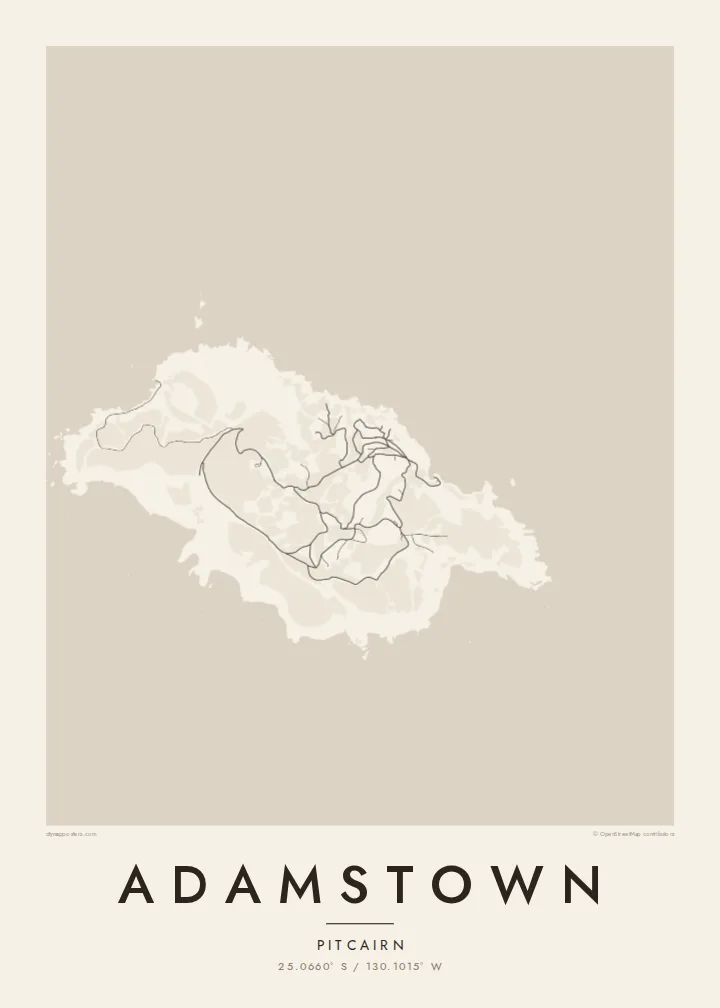
The steep track from the landing up to the village is the island's essential route, drawn on the map as a short, sharply climbing line from the shore.
Beot el poster er a chizu · Pitcairn Islands
25.0660° S / 130.1015° W
The only settlement on Pitcairn, a scatter of homes and dirt tracks on green slopes high above Bounty Bay.




Ta el beluu, eim el style
Chotii a style e mo omes er ngii er a bades. A rokui el style a diak el mora el ongraol — el lidudech, el ngar er a bilong, me a lechub el HD el file.
 Mera el pixel · 24 × 36″ el print file
Kmal ungil el print
Tiaikid a 100% el cheldechedechal a mera el print file. A rokui el poster — lidudech, ngar er a bilong, me a lechub e download — a mengedmokl er a server er kid er a 300 DPI, el mo er a 7,200 × 10,800 pixel, me a kekerei el rael a blechoel el mo klemedengei er a 24 × 36″ el print.
Er a bab er a mederrekong


A chizu
Adamstown is the capital and only village of the Pitcairn Islands, a British Overseas Territory in the South Pacific and one of the least populated jurisdictions in the world. The island was settled in 1790 by mutineers from HMS Bounty and the Tahitians who travelled with them, and many of today's islanders are their descendants. The village is named after John Adams, the last surviving mutineer.
On a map, Adamstown is not a grid but a loose arrangement of houses and public buildings along a network of unpaved tracks on the island's northern slopes. A steep road known as the Hill of Difficulty climbs from the landing at Bounty Bay to the village, and a few further tracks wander out across the rest of the island's small, rugged surface.
Pitcairn is volcanic and only a few square kilometres in area, with cliffs on almost every side and no harbour for large ships. An Adamstown map poster reflects that intimacy of scale: a handful of lines on a hillside and the long, rocky coast of an island where every track eventually leads back to the sea.
The steep track from the landing up to the village is the island's essential route, drawn on the map as a short, sharply climbing line from the shore.
A small cove on the northeast coast serves as the island's landing place, a modest indentation in a coastline otherwise defined by cliffs and rock.
Unpaved roads and paths spread loosely across the slopes around Adamstown, linking homes, public buildings and outlying plots in an informal, organic web.
Meruul el bo er kau
Mruul a sils, ngakl me a tekoi er kau, me ke olsisebii a style, klungel me a orientation.
A ngeasek el preview a kekerei a resolution e ngar er ngii a watermark. A Prints me a HD files a mengedmokl er a 300 DPI, el mo er a 7,200 × 10,800 px, el diak a watermark.
Ngera me a Adamstown
Adamstown is a map for people fascinated by the Bounty story, for descendants of the island families, and for those who collect the world's most remote places. Its few, almost hand-drawn lines and generous coastline make a thoughtful piece for a study or library wall.
Add a title, a subtitle or a date of your choosing, and a coordinates line, then choose Classic black & white, Noir, Paper, Blueprint or Sand. The Paper style gives it the feel of an old chart. Download for $9, or order a matte print with an optional wooden frame.
Oid a Adamstown el poster| Klungel er a print | Resolution | File |
|---|---|---|
| 30 × 40 cm11.8 × 15.7″ | 3,543 × 4,724 px | PNG · PDF |
| 29.7 × 42 cm (A3)11.7 × 16.5″ | 3,508 × 4,961 px | PNG · PDF |
| 42 × 59.4 cm (A2)16.5 × 23.4″ | 4,961 × 7,016 px | PNG · PDF |
| 45.7 × 61 cm18 × 24″ | 5,400 × 7,200 px | PNG · PDF |
| 50 × 70 cm19.7 × 27.6″ | 5,906 × 8,268 px | PNG · PDF |
| 61 × 91.4 cm24 × 36″ | 7,200 × 10,800 px | PNG · PDF |
A preview el diak el oldars a 900 px a klungel, ngar er ngii a watermark, e ng el kirel a screen. A HD file a ngar er ngii a 8× el klou el resolution, e ungil el print er a rokui el klungel er a poster.
Mengai a style er a eou er a page, e mongdibel a Printed Poster — el size, e a lechub e bilong — me a lechub e Digital HD Files. A checkout a di di tang el rrael, e a order page er kau a mo mechesang sel mo merek a udoud.
Ngii a lidudech er a klou el ungil 200 gsm matte el babier er a tang er a euid el size, mei er a 30 × 40 cm el mo er a 24 × 36″. A lidudech el poster a mo mekedeb er a $39, e a shipping a diak longraol.
Choi. Melilt a mera el kerrekar el frame er a chelellakl, chesisebangiau, natural oak, me a chelebacheb el kerrekar. Ngii a ngar er ngii a glazing el diak lebo lengebechel, e mo klemedengei el mo lomelilt. A framed poster a mo mekedeb er a $99, e a shipping a diak longraol.
A ngarngii a mengedub el mo er a 60+ el beluu. A chelsel poster a mebo mengelebed er a ngii el print partner er tial ngii el kmal ngar er ngii er a 30+ el beluu, ma e ng di meruul er a 3–7 el ngarngii el rak. Ke mo mesaul a status me a tracking er ngii er a My Orders. A ta el beluu a mo mekesai 2–5 el ngarngii el bak, ma el di ngar a beluu el diak mo medengelii, a site a mo kmeklii er kau el mei ng diak le mo tuobed.
Molecha a picture er kid er a uleb el 14 el sils er a lebo er a lomtok, e kid a mo di ngmuu el mengedmokl er ngii, me a lechub e mo msang a udoud er kau.
Choi. Er a editor er tia el page, molecha a title, subtitle, me a coordinates el rael el mo uangii el soam, e melilt a style me a size. A lidudech, framed, me a digital el order a rokui el mo use er a mera el design er kau.
Er a $9 e kau a mo ngmai a 300 DPI PNG me a print-ready PDF el files er a rokui el euid el size, el diak a watermark, el sebechem el mo lidudech er bek el basio. Diak dimo medengei? Download a ngeasek el preview el ngar er ngii a watermark er a uchei.
Kmeed
