Yuzhong peninsula
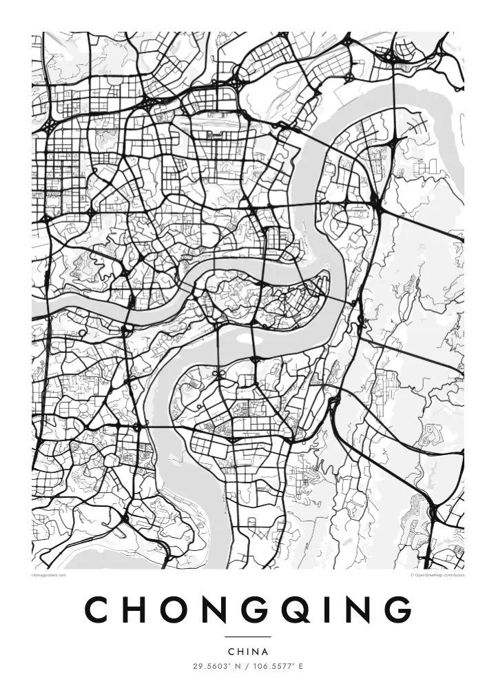
The old centre fills a slender finger of land between the Jialing and Yangtze, ending at Chaotianmen, where the two rivers meet and continue east as one.
Beot el poster er a chizu · China
29.5603° N / 106.5577° E
A mountain city folded around the meeting of two rivers, its streets climbing hillsides and bridges stitching every bank together


Ta el beluu, eim el style
Chotii a style e mo omes er ngii er a bades. A rokui el style a diak el mora el ongraol — el lidudech, el ngar er a bilong, me a lechub el HD el file.
 Mera el pixel · 24 × 36″ el print file
Kmal ungil el print
Tiaikid a 100% el cheldechedechal a mera el print file. A rokui el poster — lidudech, ngar er a bilong, me a lechub e download — a mengedmokl er a server er kid er a 300 DPI, el mo er a 7,200 × 10,800 pixel, me a kekerei el rael a blechoel el mo klemedengei er a 24 × 36″ el print.
Er a bab er a mederrekong


A chizu
Chongqing is built where the Jialing River flows into the Yangtze, and the map makes that meeting point unmistakable. The historic core of Yuzhong occupies a narrow, rocky peninsula between the two rivers, tapering to a point at Chaotianmen, where the waters join. From there the city spreads across both banks and up into the surrounding ridges, filling valleys and hilltops alike.
Few large cities are this uneven. Streets here do not follow a grid; they curve along contour lines, switch back up slopes and stop abruptly at cliffs, so the pattern on paper looks more like a set of branching veins than a planned plan. Roads sit at different levels, and a building's ground floor on one side may be several storeys up on the other.
A Chongqing map poster turns this terrain into an intricate drawing. Its many bridges, which have earned it the nickname of China's bridge city, cross the Yangtze and Jialing again and again, linking districts that the rivers and hills would otherwise keep apart. The result is one of the most distinctive urban outlines in the world.
The old centre fills a slender finger of land between the Jialing and Yangtze, ending at Chaotianmen, where the two rivers meet and continue east as one.
Roads wind around hills rather than cutting through them, so neighbourhoods appear as curling clusters of streets separated by steep slopes and gaps where the ground falls away.
Dozens of bridges span the two rivers, and on the map they appear as a series of straight lines stitching the curving banks together at regular intervals.
Meruul el bo er kau
Mruul a sils, ngakl me a tekoi er kau, me ke olsisebii a style, klungel me a orientation.
A ngeasek el preview a kekerei a resolution e ngar er ngii a watermark. A Prints me a HD files a mengedmokl er a 300 DPI, el mo er a 7,200 × 10,800 px, el diak a watermark.
Ngera me a Chongqing
For anyone who has climbed Chongqing's stairways, ridden the monorail through its hills or looked out over the rivers at night, this map is an unmistakable reminder of the city. It works as a piece for a home there, a keepsake from a trip or a gift for someone who grew up among its slopes.
Add a title and a date that matter to you, and choose from five styles: Classic black & white, Noir, Paper, Blueprint or Sand. The layered streets and river curves read clearly in every version, from dark Noir to warm, soft Sand.
Oid a Chongqing el poster| Klungel er a print | Resolution | File |
|---|---|---|
| 30 × 40 cm11.8 × 15.7″ | 3,543 × 4,724 px | PNG · PDF |
| 29.7 × 42 cm (A3)11.7 × 16.5″ | 3,508 × 4,961 px | PNG · PDF |
| 42 × 59.4 cm (A2)16.5 × 23.4″ | 4,961 × 7,016 px | PNG · PDF |
| 45.7 × 61 cm18 × 24″ | 5,400 × 7,200 px | PNG · PDF |
| 50 × 70 cm19.7 × 27.6″ | 5,906 × 8,268 px | PNG · PDF |
| 61 × 91.4 cm24 × 36″ | 7,200 × 10,800 px | PNG · PDF |
A preview el diak el oldars a 900 px a klungel, ngar er ngii a watermark, e ng el kirel a screen. A HD file a ngar er ngii a 8× el klou el resolution, e ungil el print er a rokui el klungel er a poster.
Mengai a style er a eou er a page, e mongdibel a Printed Poster — el size, e a lechub e bilong — me a lechub e Digital HD Files. A checkout a di di tang el rrael, e a order page er kau a mo mechesang sel mo merek a udoud.
Ngii a lidudech er a klou el ungil 200 gsm matte el babier er a tang er a euid el size, mei er a 30 × 40 cm el mo er a 24 × 36″. A lidudech el poster a mo mekedeb er a $39, e a shipping a diak longraol.
Choi. Melilt a mera el kerrekar el frame er a chelellakl, chesisebangiau, natural oak, me a chelebacheb el kerrekar. Ngii a ngar er ngii a glazing el diak lebo lengebechel, e mo klemedengei el mo lomelilt. A framed poster a mo mekedeb er a $99, e a shipping a diak longraol.
A ngarngii a mengedub el mo er a 60+ el beluu. A chelsel poster a mebo mengelebed er a ngii el print partner er tial ngii el kmal ngar er ngii er a 30+ el beluu, ma e ng di meruul er a 3–7 el ngarngii el rak. Ke mo mesaul a status me a tracking er ngii er a My Orders. A ta el beluu a mo mekesai 2–5 el ngarngii el bak, ma el di ngar a beluu el diak mo medengelii, a site a mo kmeklii er kau el mei ng diak le mo tuobed.
Molecha a picture er kid er a uleb el 14 el sils er a lebo er a lomtok, e kid a mo di ngmuu el mengedmokl er ngii, me a lechub e mo msang a udoud er kau.
Choi. Er a editor er tia el page, molecha a title, subtitle, me a coordinates el rael el mo uangii el soam, e melilt a style me a size. A lidudech, framed, me a digital el order a rokui el mo use er a mera el design er kau.
Er a $9 e kau a mo ngmai a 300 DPI PNG me a print-ready PDF el files er a rokui el euid el size, el diak a watermark, el sebechem el mo lidudech er bek el basio. Diak dimo medengei? Download a ngeasek el preview el ngar er ngii a watermark er a uchei.
Kmeed
