Huai River
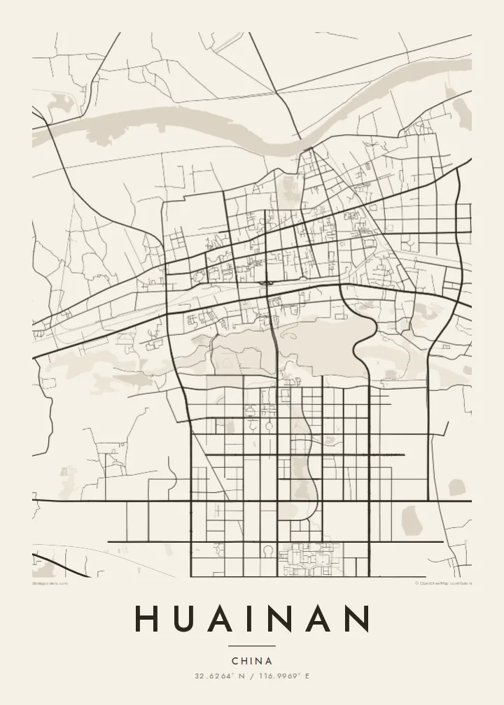
The river runs along the northern edge of the city, broad and slowly curving. Bridges and embankments mark where the urban area meets the water.
Beot el poster er a chizu · China
32.6264° N / 116.9969° E
A coal city stretched along the southern bank of the Huai River, its districts strung out between the water and low hills.




Ta el beluu, eim el style
Chotii a style e mo omes er ngii er a bades. A rokui el style a diak el mora el ongraol — el lidudech, el ngar er a bilong, me a lechub el HD el file.
 Mera el pixel · 24 × 36″ el print file
Kmal ungil el print
Tiaikid a 100% el cheldechedechal a mera el print file. A rokui el poster — lidudech, ngar er a bilong, me a lechub e download — a mengedmokl er a server er kid er a 300 DPI, el mo er a 7,200 × 10,800 pixel, me a kekerei el rael a blechoel el mo klemedengei er a 24 × 36″ el print.
Er a bab er a mederrekong


A chizu
Huainan grew in the twentieth century as a coal-mining city in central Anhui, and its map reflects that origin. It did not spread from a single old centre. Instead it developed around separate mining areas along the southern bank of the Huai River, so its districts stretch out in a long east–west line with open land and water between them.
The Huai River is the clearest line on the map, a wide, curving waterway that marks the traditional division between northern and southern China. Mining subsidence has created lakes and wetlands in several parts of the area. Some have been turned into parks, adding irregular open shapes to the street pattern.
The city's name is linked to Liu An, Prince of Huainan in the Han dynasty and compiler of the Huainanzi, and tradition credits the region with the invention of tofu. Nearby Bagong Mountain is associated with the Battle of the Fei River. A Huainan map poster shows a city defined by its river and its industry.
The river runs along the northern edge of the city, broad and slowly curving. Bridges and embankments mark where the urban area meets the water.
Separate urban districts line up from east to west, joined by long main roads. The map's elongated outline comes from mining history rather than a planned centre.
Lakes that formed over old mine workings appear as irregular open areas among the streets. Some are now landscaped, a distinctive feature of coal cities on the plain.
Meruul el bo er kau
Mruul a sils, ngakl me a tekoi er kau, me ke olsisebii a style, klungel me a orientation.
A ngeasek el preview a kekerei a resolution e ngar er ngii a watermark. A Prints me a HD files a mengedmokl er a 300 DPI, el mo er a 7,200 × 10,800 px, el diak a watermark.
Ngera me a Huainan
Huainan is hung by people who grew up with its mines, its river and its tofu dishes. For families who have lived there for generations, the map records a place that has changed a great deal and keeps changing.
Choose a title and subtitle, and keep or edit the coordinates line. Classic black & white, Noir, Paper, Blueprint and Sand are all available. The $9 digital files come in six sizes, and a free watermarked preview lets you check the framing first.
Oid a Huainan el poster| Klungel er a print | Resolution | File |
|---|---|---|
| 30 × 40 cm11.8 × 15.7″ | 3,543 × 4,724 px | PNG · PDF |
| 29.7 × 42 cm (A3)11.7 × 16.5″ | 3,508 × 4,961 px | PNG · PDF |
| 42 × 59.4 cm (A2)16.5 × 23.4″ | 4,961 × 7,016 px | PNG · PDF |
| 45.7 × 61 cm18 × 24″ | 5,400 × 7,200 px | PNG · PDF |
| 50 × 70 cm19.7 × 27.6″ | 5,906 × 8,268 px | PNG · PDF |
| 61 × 91.4 cm24 × 36″ | 7,200 × 10,800 px | PNG · PDF |
A preview el diak el oldars a 900 px a klungel, ngar er ngii a watermark, e ng el kirel a screen. A HD file a ngar er ngii a 8× el klou el resolution, e ungil el print er a rokui el klungel er a poster.
Mengai a style er a eou er a page, e mongdibel a Printed Poster — el size, e a lechub e bilong — me a lechub e Digital HD Files. A checkout a di di tang el rrael, e a order page er kau a mo mechesang sel mo merek a udoud.
Ngii a lidudech er a klou el ungil 200 gsm matte el babier er a tang er a euid el size, mei er a 30 × 40 cm el mo er a 24 × 36″. A lidudech el poster a mo mekedeb er a $39, e a shipping a diak longraol.
Choi. Melilt a mera el kerrekar el frame er a chelellakl, chesisebangiau, natural oak, me a chelebacheb el kerrekar. Ngii a ngar er ngii a glazing el diak lebo lengebechel, e mo klemedengei el mo lomelilt. A framed poster a mo mekedeb er a $99, e a shipping a diak longraol.
A ngarngii a mengedub el mo er a 60+ el beluu. A chelsel poster a mebo mengelebed er a ngii el print partner er tial ngii el kmal ngar er ngii er a 30+ el beluu, ma e ng di meruul er a 3–7 el ngarngii el rak. Ke mo mesaul a status me a tracking er ngii er a My Orders. A ta el beluu a mo mekesai 2–5 el ngarngii el bak, ma el di ngar a beluu el diak mo medengelii, a site a mo kmeklii er kau el mei ng diak le mo tuobed.
Molecha a picture er kid er a uleb el 14 el sils er a lebo er a lomtok, e kid a mo di ngmuu el mengedmokl er ngii, me a lechub e mo msang a udoud er kau.
Choi. Er a editor er tia el page, molecha a title, subtitle, me a coordinates el rael el mo uangii el soam, e melilt a style me a size. A lidudech, framed, me a digital el order a rokui el mo use er a mera el design er kau.
Er a $9 e kau a mo ngmai a 300 DPI PNG me a print-ready PDF el files er a rokui el euid el size, el diak a watermark, el sebechem el mo lidudech er bek el basio. Diak dimo medengei? Download a ngeasek el preview el ngar er ngii a watermark er a uchei.
Kmeed
