Strait of Magellan
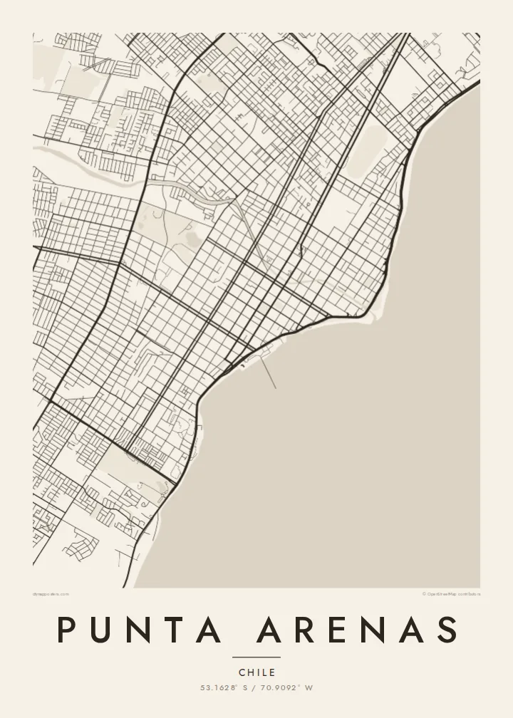
The city's whole eastern side faces the strait. On the poster it appears as a broad open plane, with the city running along one shore and Tierra del Fuego across the water.
Beot el poster er a chizu · Chile
53.1628° S / 70.9092° W
A windswept grid on the Strait of Magellan, where straight streets run down to the water facing Tierra del Fuego




Ta el beluu, eim el style
Chotii a style e mo omes er ngii er a bades. A rokui el style a diak el mora el ongraol — el lidudech, el ngar er a bilong, me a lechub el HD el file.
 Mera el pixel · 24 × 36″ el print file
Kmal ungil el print
Tiaikid a 100% el cheldechedechal a mera el print file. A rokui el poster — lidudech, ngar er a bilong, me a lechub e download — a mengedmokl er a server er kid er a 300 DPI, el mo er a 7,200 × 10,800 pixel, me a kekerei el rael a blechoel el mo klemedengei er a 24 × 36″ el print.
Er a bab er a mederrekong


A chizu
Punta Arenas stretches along the western shore of the Strait of Magellan and is one of the southernmost cities in the world. From above, it is a disciplined grid of straight streets and square blocks. The grid runs from the coastline up gentle slopes toward the hills and the Patagonian steppe. The Costanera road follows the shore, and to the east lies the open water of the strait, with Tierra del Fuego on the far side.
The city was founded in 1848 as a Chilean outpost. It prospered as a port on the route between the Atlantic and Pacific before the Panama Canal opened, and later as a centre of the sheep-farming trade. Its central square, Plaza Muñoz Gamero, is laid out around a monument to Magellan. A Punta Arenas map poster shows the plaza at the heart of a regular plan that seems built to hold firm against the wind.
In black and white, the contrast between land and sea is stark. The dense grid stops at a clean coastline, and the strait fills the rest of the frame as a single calm field. Small rivers and ravines come down from the hills and break into the rows of blocks. The result is a graphic image of a city at the edge of the continent.
The city's whole eastern side faces the strait. On the poster it appears as a broad open plane, with the city running along one shore and Tierra del Fuego across the water.
The main square sits at the centre of the grid, surrounded by regular blocks. The Magellan monument stands there, and the square is the anchor of the whole plan.
Straight streets climb from the coast toward the western hills in long parallel rows. They give the city its orderly, almost drafted look against the open landscape.
Meruul el bo er kau
Mruul a sils, ngakl me a tekoi er kau, me ke olsisebii a style, klungel me a orientation.
A ngeasek el preview a kekerei a resolution e ngar er ngii a watermark. A Prints me a HD files a mengedmokl er a 300 DPI, el mo er a 7,200 × 10,800 px, el diak a watermark.
Ngera me a Punta Arenas
Punta Arenas is often a gateway to Torres del Paine, Antarctic voyages and Tierra del Fuego, so its map works as a keepsake of a journey to the far south. For residents, it is a striking portrait of a city defined by its coastline.
You can personalise the title, subtitle and coordinates line, for example with an expedition date or a family name. Choose from five styles: Classic black & white, Noir, Paper, Blueprint and Sand. Blueprint suits the seafaring history of the port. Order it as a digital file or as a printed poster.
Oid a Punta Arenas el poster| Klungel er a print | Resolution | File |
|---|---|---|
| 30 × 40 cm11.8 × 15.7″ | 3,543 × 4,724 px | PNG · PDF |
| 29.7 × 42 cm (A3)11.7 × 16.5″ | 3,508 × 4,961 px | PNG · PDF |
| 42 × 59.4 cm (A2)16.5 × 23.4″ | 4,961 × 7,016 px | PNG · PDF |
| 45.7 × 61 cm18 × 24″ | 5,400 × 7,200 px | PNG · PDF |
| 50 × 70 cm19.7 × 27.6″ | 5,906 × 8,268 px | PNG · PDF |
| 61 × 91.4 cm24 × 36″ | 7,200 × 10,800 px | PNG · PDF |
A preview el diak el oldars a 900 px a klungel, ngar er ngii a watermark, e ng el kirel a screen. A HD file a ngar er ngii a 8× el klou el resolution, e ungil el print er a rokui el klungel er a poster.
Mengai a style er a eou er a page, e mongdibel a Printed Poster — el size, e a lechub e bilong — me a lechub e Digital HD Files. A checkout a di di tang el rrael, e a order page er kau a mo mechesang sel mo merek a udoud.
Ngii a lidudech er a klou el ungil 200 gsm matte el babier er a tang er a euid el size, mei er a 30 × 40 cm el mo er a 24 × 36″. A lidudech el poster a mo mekedeb er a $39, e a shipping a diak longraol.
Choi. Melilt a mera el kerrekar el frame er a chelellakl, chesisebangiau, natural oak, me a chelebacheb el kerrekar. Ngii a ngar er ngii a glazing el diak lebo lengebechel, e mo klemedengei el mo lomelilt. A framed poster a mo mekedeb er a $99, e a shipping a diak longraol.
A ngarngii a mengedub el mo er a 60+ el beluu. A chelsel poster a mebo mengelebed er a ngii el print partner er tial ngii el kmal ngar er ngii er a 30+ el beluu, ma e ng di meruul er a 3–7 el ngarngii el rak. Ke mo mesaul a status me a tracking er ngii er a My Orders. A ta el beluu a mo mekesai 2–5 el ngarngii el bak, ma el di ngar a beluu el diak mo medengelii, a site a mo kmeklii er kau el mei ng diak le mo tuobed.
Molecha a picture er kid er a uleb el 14 el sils er a lebo er a lomtok, e kid a mo di ngmuu el mengedmokl er ngii, me a lechub e mo msang a udoud er kau.
Choi. Er a editor er tia el page, molecha a title, subtitle, me a coordinates el rael el mo uangii el soam, e melilt a style me a size. A lidudech, framed, me a digital el order a rokui el mo use er a mera el design er kau.
Er a $9 e kau a mo ngmai a 300 DPI PNG me a print-ready PDF el files er a rokui el euid el size, el diak a watermark, el sebechem el mo lidudech er bek el basio. Diak dimo medengei? Download a ngeasek el preview el ngar er ngii a watermark er a uchei.
Kmeed
