Taedong River
The wide river divides the city into two halves. Several bridges cross it, and embankments give both shores a clean, continuous edge.
Beot el poster er a chizu · North Korea
39.0339° N / 125.7543° E
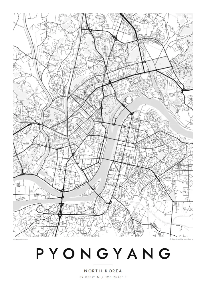
A capital divided by the broad Taedong River, with wide boulevards, riverside monuments and long islands in the stream.


Ta el beluu, eim el style
Chotii a style e mo omes er ngii er a bades. A rokui el style a diak el mora el ongraol — el lidudech, el ngar er a bilong, me a lechub el HD el file.
 Mera el pixel · 24 × 36″ el print file
Kmal ungil el print
Tiaikid a 100% el cheldechedechal a mera el print file. A rokui el poster — lidudech, ngar er a bilong, me a lechub e download — a mengedmokl er a server er kid er a 300 DPI, el mo er a 7,200 × 10,800 pixel, me a kekerei el rael a blechoel el mo klemedengei er a 24 × 36″ el print.
Er a bab er a mederrekong


A chizu
Pyongyang is built on both banks of the Taedong River, which curves through the city in a wide band and is the dominant feature of the map. The city was almost entirely destroyed during the Korean War and rebuilt from the 1950s onward. Most of what appears from above is a planned layout of broad avenues, large blocks and open squares.
The formal centre faces the river. Kim Il Sung Square opens onto the west bank. Directly opposite, on the east bank, the Juche Tower rises from a riverside plaza, and the two form a deliberate axis across the water. North of the centre, Moranbong Hill is a wooded rise above the river, and the pyramid-shaped Ryugyong Hotel dominates the skyline to the north-west.
The river holds several islands, including Rungra, home to the large May Day Stadium, and Yanggak, with its tall hotel. The Pothong River, a smaller tributary, winds through the western districts. A Pyongyang map poster presents the city simply as geography: river, bridges, islands and the planned grid laid over them, readable without knowing a single street name.
The wide river divides the city into two halves. Several bridges cross it, and embankments give both shores a clean, continuous edge.
A long island in the river upstream of the centre, taken up largely by the May Day Stadium and parkland. Its elongated shape is clearly visible on the map.
Kim Il Sung Square on the west bank and the Juche Tower on the east bank line up across the river. Together they form one of the most deliberate compositions in the city plan.
Meruul el bo er kau
Mruul a sils, ngakl me a tekoi er kau, me ke olsisebii a style, klungel me a orientation.
A ngeasek el preview a kekerei a resolution e ngar er ngii a watermark. A Prints me a HD files a mengedmokl er a 300 DPI, el mo er a 7,200 × 10,800 px, el diak a watermark.
Ngera me a Pyongyang
Few people have walked Pyongyang's streets, which makes its map an unusual object. It works as a study in postwar planning, a reference for readers of Korean history, or a keepsake for those who have visited. The river and islands give it a strong, clean composition.
The title, subtitle and coordinates line can be edited freely. Choose one of five styles, including the high-contrast Noir and the technical Blueprint. The $9 download covers six print sizes as PNG and PDF, and printed posters are also available.
Oid a Pyongyang el poster| Klungel er a print | Resolution | File |
|---|---|---|
| 30 × 40 cm11.8 × 15.7″ | 3,543 × 4,724 px | PNG · PDF |
| 29.7 × 42 cm (A3)11.7 × 16.5″ | 3,508 × 4,961 px | PNG · PDF |
| 42 × 59.4 cm (A2)16.5 × 23.4″ | 4,961 × 7,016 px | PNG · PDF |
| 45.7 × 61 cm18 × 24″ | 5,400 × 7,200 px | PNG · PDF |
| 50 × 70 cm19.7 × 27.6″ | 5,906 × 8,268 px | PNG · PDF |
| 61 × 91.4 cm24 × 36″ | 7,200 × 10,800 px | PNG · PDF |
A preview el diak el oldars a 900 px a klungel, ngar er ngii a watermark, e ng el kirel a screen. A HD file a ngar er ngii a 8× el klou el resolution, e ungil el print er a rokui el klungel er a poster.
Mengai a style er a eou er a page, e mongdibel a Printed Poster — el size, e a lechub e bilong — me a lechub e Digital HD Files. A checkout a di di tang el rrael, e a order page er kau a mo mechesang sel mo merek a udoud.
Ngii a lidudech er a klou el ungil 200 gsm matte el babier er a tang er a euid el size, mei er a 30 × 40 cm el mo er a 24 × 36″. A lidudech el poster a mo mekedeb er a $39, e a shipping a diak longraol.
Choi. Melilt a mera el kerrekar el frame er a chelellakl, chesisebangiau, natural oak, me a chelebacheb el kerrekar. Ngii a ngar er ngii a glazing el diak lebo lengebechel, e mo klemedengei el mo lomelilt. A framed poster a mo mekedeb er a $99, e a shipping a diak longraol.
A ngarngii a mengedub el mo er a 60+ el beluu. A chelsel poster a mebo mengelebed er a ngii el print partner er tial ngii el kmal ngar er ngii er a 30+ el beluu, ma e ng di meruul er a 3–7 el ngarngii el rak. Ke mo mesaul a status me a tracking er ngii er a My Orders. A ta el beluu a mo mekesai 2–5 el ngarngii el bak, ma el di ngar a beluu el diak mo medengelii, a site a mo kmeklii er kau el mei ng diak le mo tuobed.
Molecha a picture er kid er a uleb el 14 el sils er a lebo er a lomtok, e kid a mo di ngmuu el mengedmokl er ngii, me a lechub e mo msang a udoud er kau.
Choi. Er a editor er tia el page, molecha a title, subtitle, me a coordinates el rael el mo uangii el soam, e melilt a style me a size. A lidudech, framed, me a digital el order a rokui el mo use er a mera el design er kau.
Er a $9 e kau a mo ngmai a 300 DPI PNG me a print-ready PDF el files er a rokui el euid el size, el diak a watermark, el sebechem el mo lidudech er bek el basio. Diak dimo medengei? Download a ngeasek el preview el ngar er ngii a watermark er a uchei.
Kmeed
