Caspian shoreline
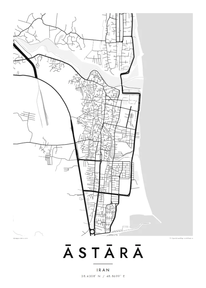
A long, smooth coast runs north to south along the eastern edge of the town, with beaches and small harbour structures set along it.
සරල සිතියම් පෝස්ටරය · ඉරානය
38.4308° N / 48.8699° E
A Caspian border town on a narrow coastal strip, divided from its Azerbaijani namesake by a small river.


එක් නගරයක්, මනෝභාව පහක්
ශෛලියක් තට්ටු කර එය බිත්තියේ බලන්න. සෑම ශෛලියක්ම එකම මිලට — මුද්රිත, රාමු කළ හෝ HD ගොනු ලෙස.
 සැබෑ පික්සල් · 24 × 36″ මුද්රණ ගොනුව
මුද්රණයට තියුණු
මෙය සැබෑ මුද්රණ ගොනුවේ 100% කැපුමකි. සෑම පෝස්ටරයක්ම — මුද්රිත, රාමු කළ හෝ බාගත කළ — අපගේ සර්වර්වල 300 DPI වලින්, 7,200 × 10,800 පික්සල් දක්වා විදැහුම් කරනු ලැබේ, එමගින් 24 × 36″ මුද්රණයක සිඟුම් වීදිවත් පැහැදිලිව පෙනේ.
බිත්තියේ


සිතියම
Āstārā lies in the far northwest corner of Gilan Province, where Iran's Caspian coast meets the border with Azerbaijan. The town occupies a narrow band of flat land between the sea and the forested Talysh mountains, so its streets are pressed into a long, thin shape running parallel to the shore.
The Astarachay river marks the frontier, and on the far bank lies Astara in Azerbaijan, a separate town with the same name. This makes Āstārā an important crossing point for trade and travel, and the area around the border bridge is one of the most active parts of the town throughout the day.
Inland, a road climbs steeply over the Heyran pass toward Ardabil, winding through forest that is often wrapped in mist. On an Āstārā map poster the contrast is clear: the straight coastline, the river border and the dense town on one side, and the first curves of the mountain road cutting into wooded slopes on the other.
A long, smooth coast runs north to south along the eastern edge of the town, with beaches and small harbour structures set along it.
The narrow river forms the international border with Azerbaijan, dividing two towns of the same name and crossed by the frontier bridge.
West of town, the road to Ardabil climbs into the Talysh mountains in tight curves, one of the best-known scenic routes in northern Iran.
ඔබේම කරගන්න
දිනයක්, නමක් හෝ ඔබේම වාක්යයක් එක් කරන්න, ශෛලිය, ප්රමාණය හෝ දිශානතිය වෙනස් කරන්න.
නොමිලේ පෙරදසුන අඩු විභේදනයෙන් සහ watermark සමඟින් වේ. මුද්රණ සහ HD ගොනු watermark නොමැතිව, 300 DPI, 7,200 × 10,800 px දක්වා විදැහුම් කරනු ලැබේ.
ඇයි Āstārā
Āstārā is familiar to travellers crossing between Iran and Azerbaijan and to families from Gilan's green coast. A map of its streets, river and shore captures a very particular place where two countries and the sea meet.
Personalise the title, subtitle and coordinates line, perhaps with the date of a crossing or a family name. Choose one of five styles, Classic black & white, Noir, Paper, Blueprint or Sand; Blueprint and Noir suit the strong coastline especially well.
Āstārā පෝස්ටරය ඇණවුම් කරන්න| මුද්රණ ප්රමාණය | විභේදනය | ගොනු |
|---|---|---|
| 30 × 40 cm (11.8 × 15.7″) | 3,543 × 4,724 px | PNG · PDF |
| 29.7 × 42 cm (A3, 11.7 × 16.5″) | 3,508 × 4,961 px | PNG · PDF |
| 42 × 59.4 cm (A2, 16.5 × 23.4″) | 4,961 × 7,016 px | PNG · PDF |
| 45.7 × 61 cm (18 × 24″) | 5,400 × 7,200 px | PNG · PDF |
| 50 × 70 cm (19.7 × 27.6″) | 5,906 × 8,268 px | PNG · PDF |
| 61 × 91.4 cm (24 × 36″) | 7,200 × 10,800 px | PNG · PDF |
සැසඳීම සඳහා, නොමිලේ ලැබෙන පෙරදසුන 900 px පළල, ජල සලකුණු සහිත සහ තිර සඳහා අදහස් කළකි. HD ගොනුවල එක් එක් දිශාවට 8 ගුණයක් දක්වා විභේදනයක් ඇති අතර සම්පූර්ණ පෝස්ටර් ප්රමාණයෙන් පිරිසිදුව මුද්රණය වේ.
පිටුවේ ඉහළින් ශෛලියක් තෝරන්න, පසුව මුද්රිත පෝස්ටරය — ප්රමාණයක් සහ, ඔබ කැමති නම්, රාමුවක් — හෝ Digital HD Files තෝරන්න. ගෙවීම එක් පියවරකින් සිදු වන අතර, ගෙවීම සම්පූර්ණ වූ විගසම ඔබේ ඇණවුම් පිටුව යාවත්කාලීන වේ.
එය 30 × 40 cm සිට 24 × 36″ දක්වා ප්රමාණ හයකින් ප්රිමියම් 200 gsm මැට් කඩදාසි මත මුද්රණය කෙරේ. මුද්රිත පෝස්ටර $39 සිට ආරම්භ වේ, බෙදාහැරීම ඇතුළුව.
ඔව්. කළු, සුදු, ස්වාභාවික ඕක් හෝ තද පැහැති දැව රාමුවක් තෝරන්න. එය කැඩෙන්නට නොහැකි වීදුරුවක් සමඟින් සූදානම්ව එනු ලබන අතර එසැණින් එල්ලීමට හැකිය. රාමු කළ පෝස්ටර $99 සිට ආරම්භ වේ, බෙදාහැරීම ඇතුළුව.
ලොව පුරා නොමිලේ බෙදාහැරීම. සෑම පෝස්ටරයක්ම රටවල් 30+ ක අපගේ මුද්රණ හවුල්කරුවන්ගෙන් ඔබට ළඟම සිටින අයෙකු විසින් මුද්රණය කරන අතර සාමාන්යයෙන් වැඩ කරන දින 3–7 ක් ඇතුළත ලැබේ. තත්ත්වය සහ ලුහුබැඳීම "මගේ ඇණවුම්" යටතේ බලාගත හැක. සමහර රටවලට සති 2–5 ක් ගත වන අතර, අපි තවමත් බෙදාහරින්නේ නැති රටවල් සම්බන්ධයෙන් ගෙවීමට පෙර අඩවිය ඔබට දැනුම් දෙයි.
බෙදාහැරීමෙන් දින 14ක් ඇතුළත අපට ඡායාරූපයක් යවන්න, අපි එය නොමිලේ නැවත මුද්රණය කරන්නෙමු හෝ ඔබට මුදල් ආපසු ලබා දෙන්නෙමු.
ඔව්. මෙම පිටුවේ එඩිටරයේ, මාතෘකාව, උපමාතෘකාව සහ ඛණාංක රේඛාව ඔබට කැමති ඕනෑම දෙයකට වෙනස් කර, ශෛලියක් සහ ප්රමාණයක් තෝරන්න. මුද්රිත, රාමු කළ සහ ඩිජිටල් ඇණවුම් සියල්ලම හරියටම ඔබේ නිර්මාණය භාවිත කරයි.
$9කට ඔබට ප්රමාණ හයම සඳහා 300 DPI PNG සහ මුද්රණයට සූදානම් PDF ගොනු, watermark නොමැතිව, ඕනෑම තැනක මුද්රණය කිරීමට ලැබේ. තවම විශ්වාස නැද්ද? මුලින්ම නොමිලේ watermark සහිත පෙරදසුනක් බාගන්න.
