Dana Point Harbor
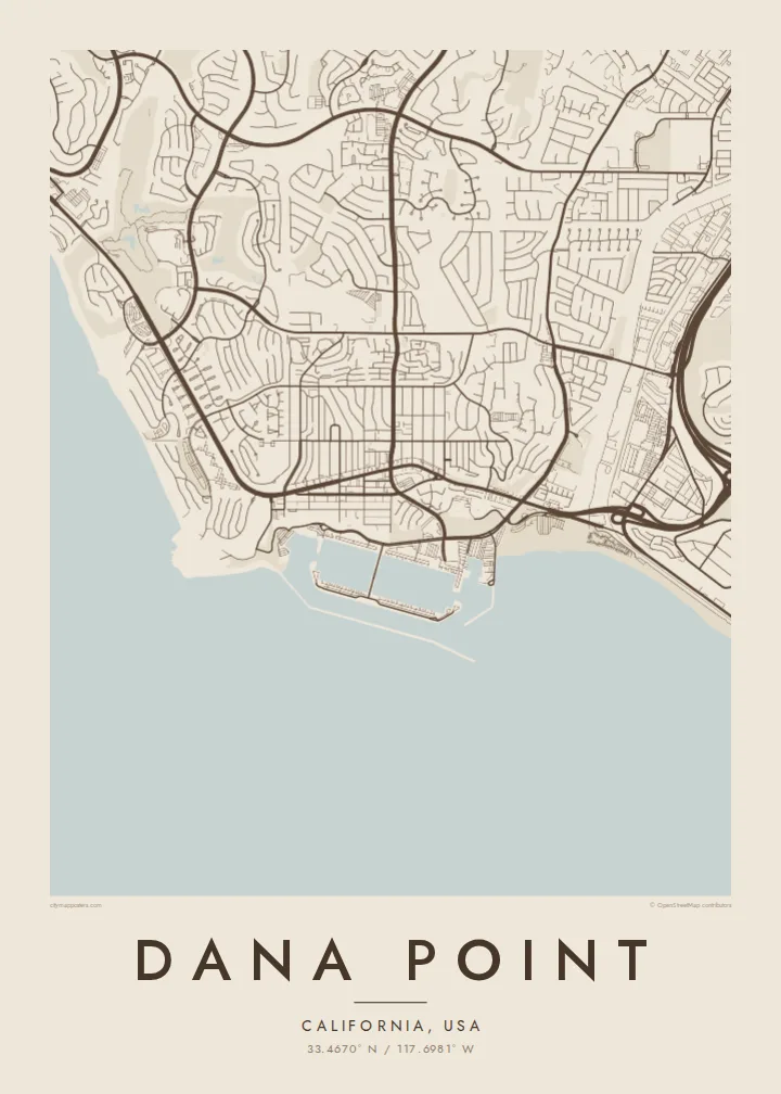
Long breakwaters enclose the harbour, creating a sheltered basin of marinas and boat slips that forms the most geometric shape on the coastline.
සරල සිතියම් පෝස්ටරය · එක්සත් ජනපදය
33.4670° N / 117.6981° W
A coastal city of headlands, a sheltered harbour and canyon streets, stepping down to the Pacific in Orange County.


එක් නගරයක්, මනෝභාව පහක්
ශෛලියක් තට්ටු කර එය බිත්තියේ බලන්න. සෑම ශෛලියක්ම එකම මිලට — මුද්රිත, රාමු කළ හෝ HD ගොනු ලෙස.
 සැබෑ පික්සල් · 24 × 36″ මුද්රණ ගොනුව
මුද්රණයට තියුණු
මෙය සැබෑ මුද්රණ ගොනුවේ 100% කැපුමකි. සෑම පෝස්ටරයක්ම — මුද්රිත, රාමු කළ හෝ බාගත කළ — අපගේ සර්වර්වල 300 DPI වලින්, 7,200 × 10,800 පික්සල් දක්වා විදැහුම් කරනු ලැබේ, එමගින් 24 × 36″ මුද්රණයක සිඟුම් වීදිවත් පැහැදිලිව පෙනේ.
බිත්තියේ


සිතියම
Dana Point lies on the southern Orange County coast, between Laguna Beach and San Clemente. The map is shaped by the shoreline: rocky headlands, sandy coves and a large man-made harbour protected by long breakwaters. Streets follow the hills and canyons inland, curving around slopes and opening onto terraces that step down to the Pacific.
The city takes its name from Richard Henry Dana Jr., who described the headland in Two Years Before the Mast, his account of a voyage along the California coast in the 1830s. Today Dana Point Harbor is the centre of the city's waterfront, with marinas and boat slips laid out in neat geometric patterns inside the breakwater.
South of the harbour, San Juan Creek reaches the sea at Doheny State Beach, and the coast continues toward Capistrano Beach. Dana Point is also known for whale watching, with gray whales passing offshore during their migration. A Dana Point map poster shows this interplay of harbour, headland, beach and hillside neighbourhoods in clean detail.
Long breakwaters enclose the harbour, creating a sheltered basin of marinas and boat slips that forms the most geometric shape on the coastline.
Rocky promontories break up the shoreline, including the headland that gave the city its name, forming bold outlines against the sea.
Where San Juan Creek meets the ocean, the beach spreads in a broad sandy curve, adding a soft edge next to the harbour.
ඔබේම කරගන්න
දිනයක්, නමක් හෝ ඔබේම වාක්යයක් එක් කරන්න, ශෛලිය, ප්රමාණය හෝ දිශානතිය වෙනස් කරන්න.
නොමිලේ පෙරදසුන අඩු විභේදනයෙන් සහ watermark සමඟින් වේ. මුද්රණ සහ HD ගොනු watermark නොමැතිව, 300 DPI, 7,200 × 10,800 px දක්වා විදැහුම් කරනු ලැබේ.
ඇයි Dana Point
Dana Point's coastline makes a striking map, with harbour, headlands and beaches all in one frame. It suits a beach house, a sailing enthusiast or anyone who has watched whales off this stretch of coast.
Add a title, subtitle and coordinates, and choose Classic black & white, Noir, Paper, Blueprint or Sand. The digital files are $9 for six sizes, including 18×24″ and 24×36″, with printed posters available too.
Dana Point පෝස්ටරය ඇණවුම් කරන්න| මුද්රණ ප්රමාණය | විභේදනය | ගොනු |
|---|---|---|
| 30 × 40 cm11.8 × 15.7″ | 3,543 × 4,724 px | PNG · PDF |
| 29.7 × 42 cm (A3)11.7 × 16.5″ | 3,508 × 4,961 px | PNG · PDF |
| 42 × 59.4 cm (A2)16.5 × 23.4″ | 4,961 × 7,016 px | PNG · PDF |
| 45.7 × 61 cm18 × 24″ | 5,400 × 7,200 px | PNG · PDF |
| 50 × 70 cm19.7 × 27.6″ | 5,906 × 8,268 px | PNG · PDF |
| 61 × 91.4 cm24 × 36″ | 7,200 × 10,800 px | PNG · PDF |
සැසඳීම සඳහා, නොමිලේ ලැබෙන පෙරදසුන 900 px පළල, ජල සලකුණු සහිත සහ තිර සඳහා අදහස් කළකි. HD ගොනුවල එක් එක් දිශාවට 8 ගුණයක් දක්වා විභේදනයක් ඇති අතර සම්පූර්ණ පෝස්ටර් ප්රමාණයෙන් පිරිසිදුව මුද්රණය වේ.
පිටුවේ ඉහළින් ශෛලියක් තෝරන්න, පසුව මුද්රිත පෝස්ටරය — ප්රමාණයක් සහ, ඔබ කැමති නම්, රාමුවක් — හෝ Digital HD Files තෝරන්න. ගෙවීම එක් පියවරකින් සිදු වන අතර, ගෙවීම සම්පූර්ණ වූ විගසම ඔබේ ඇණවුම් පිටුව යාවත්කාලීන වේ.
එය 30 × 40 cm සිට 24 × 36″ දක්වා ප්රමාණ හයකින් ප්රිමියම් 200 gsm මැට් කඩදාසි මත මුද්රණය කෙරේ. මුද්රිත පෝස්ටර $39 සිට ආරම්භ වේ, බෙදාහැරීම ඇතුළුව.
ඔව්. කළු, සුදු, ස්වාභාවික ඕක් හෝ තද පැහැති දැව රාමුවක් තෝරන්න. එය කැඩෙන්නට නොහැකි වීදුරුවක් සමඟින් සූදානම්ව එනු ලබන අතර එසැණින් එල්ලීමට හැකිය. රාමු කළ පෝස්ටර $99 සිට ආරම්භ වේ, බෙදාහැරීම ඇතුළුව.
රටවල් 60+ කට බෙදාහැරීම නොමිලේ. සෑම පෝස්ටරයක්ම රටවල් 30+ ක ඇති අපගේ මුද්රණ හවුල්කරුවන්ගෙන් ඔබට ළඟම සිටින අයකු විසින් මුද්රණය කර, සාමාන්යයෙන් වැඩ කරන දින 3–7 ක් ඇතුළත ලැබේ. තත්ත්වය සහ ලුහුබැඳීම My Orders යටතේ බලාගත හැක. සමහර රටවලට සති 2–5 ක් ගත වේ; අපි තවම බෙදාහරින්නේ නැති රටකට නම්, ගෙවීමට පෙර අඩවිය ඒ බව ඔබට දන්වයි.
බෙදාහැරීමෙන් දින 14ක් ඇතුළත අපට ඡායාරූපයක් යවන්න, අපි එය නොමිලේ නැවත මුද්රණය කරන්නෙමු හෝ ඔබට මුදල් ආපසු ලබා දෙන්නෙමු.
ඔව්. මෙම පිටුවේ එඩිටරයේ, මාතෘකාව, උපමාතෘකාව සහ ඛණාංක රේඛාව ඔබට කැමති ඕනෑම දෙයකට වෙනස් කර, ශෛලියක් සහ ප්රමාණයක් තෝරන්න. මුද්රිත, රාමු කළ සහ ඩිජිටල් ඇණවුම් සියල්ලම හරියටම ඔබේ නිර්මාණය භාවිත කරයි.
$9කට ඔබට ප්රමාණ හයම සඳහා 300 DPI PNG සහ මුද්රණයට සූදානම් PDF ගොනු, watermark නොමැතිව, ඕනෑම තැනක මුද්රණය කිරීමට ලැබේ. තවම විශ්වාස නැද්ද? මුලින්ම නොමිලේ watermark සහිත පෙරදසුනක් බාගන්න.
