Valley roads
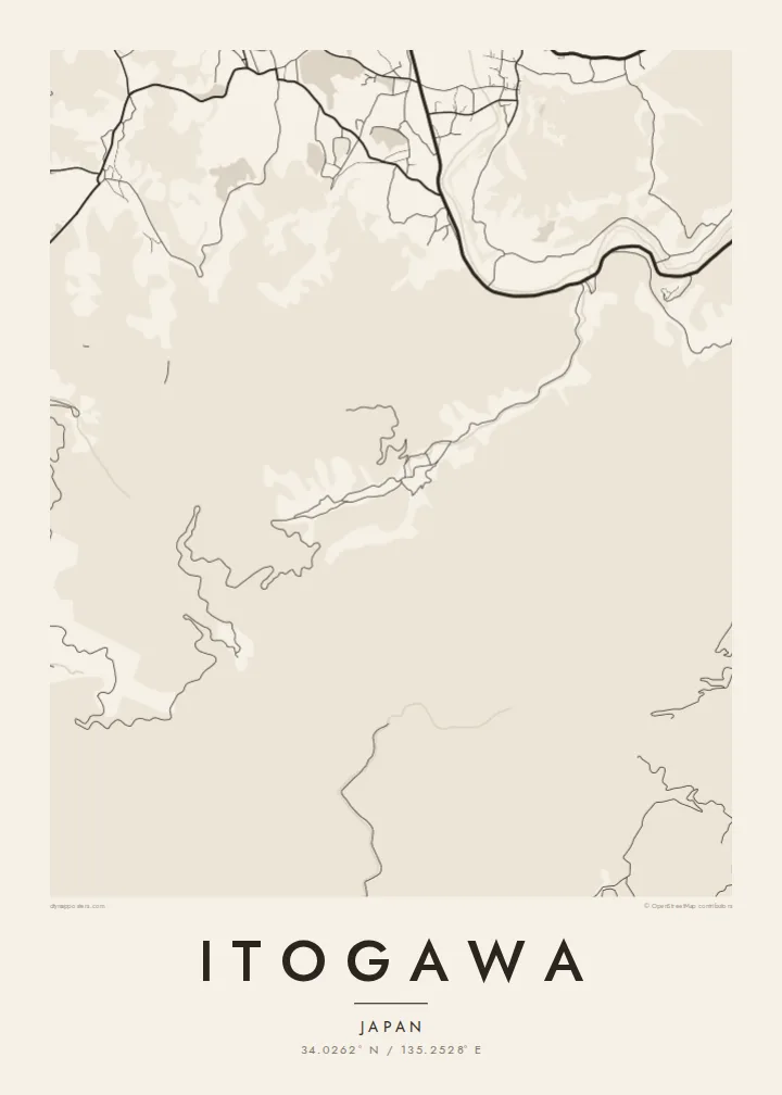
The main routes run along valley bottoms, bending with the terrain rather than following a grid, so the strongest lines on the map trace the shape of the land beneath them.
සරල සිතියම් පෝස්ටරය · ජපානය
34.0262° N / 135.2528° E
A small settlement in the folded hills of western Wakayama, where roads follow valley floors between terraced slopes.




එක් නගරයක්, මනෝභාව පහක්
ශෛලියක් තට්ටු කර එය බිත්තියේ බලන්න. සෑම ශෛලියක්ම එකම මිලට — මුද්රිත, රාමු කළ හෝ HD ගොනු ලෙස.
 සැබෑ පික්සල් · 24 × 36″ මුද්රණ ගොනුව
මුද්රණයට තියුණු
මෙය සැබෑ මුද්රණ ගොනුවේ 100% කැපුමකි. සෑම පෝස්ටරයක්ම — මුද්රිත, රාමු කළ හෝ බාගත කළ — අපගේ සර්වර්වල 300 DPI වලින්, 7,200 × 10,800 පික්සල් දක්වා විදැහුම් කරනු ලැබේ, එමගින් 24 × 36″ මුද්රණයක සිඟුම් වීදිවත් පැහැදිලිව පෙනේ.
බිත්තියේ


සිතියම
Itogawa is a small place in Wakayama Prefecture, on the western side of the Kii Peninsula. The land here is rarely flat for long: hills rise close on every side, and settlements tend to follow the narrow valleys where there is room for houses, fields and a road. On a map that produces a shape quite unlike a planned city, long and threaded rather than square.
Wakayama is best known in Japan for its citrus, and the prefecture is the country's leading producer of mikan mandarins, many of them grown on slopes facing the sea. It is also home to the Kumano pilgrimage routes and the temple settlement of Mount Kōya, both further inland and both part of a UNESCO World Heritage listing.
An Itogawa map poster captures the way people have fitted streets into terrain. Roads bend with the contours, lanes branch off into side valleys and stop, and small clusters of buildings appear wherever the ground allows. The result is an organic, almost hand-drawn pattern that feels closer to a landscape study than to a conventional city plan.
The main routes run along valley bottoms, bending with the terrain rather than following a grid, so the strongest lines on the map trace the shape of the land beneath them.
Narrow lanes climb away from the main roads toward farms and orchards on the slopes, ending in short spurs that give the edges of the map a fine, branching texture.
Large blank areas between the built-up clusters stand for forested hills and farmland, and they give the composition generous breathing room that suits a minimalist print.
ඔබේම කරගන්න
දිනයක්, නමක් හෝ ඔබේම වාක්යයක් එක් කරන්න, ශෛලිය, ප්රමාණය හෝ දිශානතිය වෙනස් කරන්න.
නොමිලේ පෙරදසුන අඩු විභේදනයෙන් සහ watermark සමඟින් වේ. මුද්රණ සහ HD ගොනු watermark නොමැතිව, 300 DPI, 7,200 × 10,800 px දක්වා විදැහුම් කරනු ලැබේ.
ඇයි Itogawa
This is a map for someone with a personal link to the area, whether through family, a stay in the countryside or a trip along the Wakayama coast. Its winding, uneven lines have a calm quality that sits well in a study, bedroom or entrance hall.
The title, subtitle and coordinates can all be changed, so the print can carry a family name and a date that matters. Choose Classic black & white, Noir, Paper, Blueprint or Sand, and check a free 900 px preview before buying.
Itogawa පෝස්ටරය ඇණවුම් කරන්න| මුද්රණ ප්රමාණය | විභේදනය | ගොනු |
|---|---|---|
| 30 × 40 cm11.8 × 15.7″ | 3,543 × 4,724 px | PNG · PDF |
| 29.7 × 42 cm (A3)11.7 × 16.5″ | 3,508 × 4,961 px | PNG · PDF |
| 42 × 59.4 cm (A2)16.5 × 23.4″ | 4,961 × 7,016 px | PNG · PDF |
| 45.7 × 61 cm18 × 24″ | 5,400 × 7,200 px | PNG · PDF |
| 50 × 70 cm19.7 × 27.6″ | 5,906 × 8,268 px | PNG · PDF |
| 61 × 91.4 cm24 × 36″ | 7,200 × 10,800 px | PNG · PDF |
සැසඳීම සඳහා, නොමිලේ ලැබෙන පෙරදසුන 900 px පළල, ජල සලකුණු සහිත සහ තිර සඳහා අදහස් කළකි. HD ගොනුවල එක් එක් දිශාවට 8 ගුණයක් දක්වා විභේදනයක් ඇති අතර සම්පූර්ණ පෝස්ටර් ප්රමාණයෙන් පිරිසිදුව මුද්රණය වේ.
පිටුවේ ඉහළින් ශෛලියක් තෝරන්න, පසුව මුද්රිත පෝස්ටරය — ප්රමාණයක් සහ, ඔබ කැමති නම්, රාමුවක් — හෝ Digital HD Files තෝරන්න. ගෙවීම එක් පියවරකින් සිදු වන අතර, ගෙවීම සම්පූර්ණ වූ විගසම ඔබේ ඇණවුම් පිටුව යාවත්කාලීන වේ.
එය 30 × 40 cm සිට 24 × 36″ දක්වා ප්රමාණ හයකින් ප්රිමියම් 200 gsm මැට් කඩදාසි මත මුද්රණය කෙරේ. මුද්රිත පෝස්ටර $39 සිට ආරම්භ වේ, බෙදාහැරීම ඇතුළුව.
ඔව්. කළු, සුදු, ස්වාභාවික ඕක් හෝ තද පැහැති දැව රාමුවක් තෝරන්න. එය කැඩෙන්නට නොහැකි වීදුරුවක් සමඟින් සූදානම්ව එනු ලබන අතර එසැණින් එල්ලීමට හැකිය. රාමු කළ පෝස්ටර $99 සිට ආරම්භ වේ, බෙදාහැරීම ඇතුළුව.
රටවල් 60+ කට බෙදාහැරීම නොමිලේ. සෑම පෝස්ටරයක්ම රටවල් 30+ ක ඇති අපගේ මුද්රණ හවුල්කරුවන්ගෙන් ඔබට ළඟම සිටින අයකු විසින් මුද්රණය කර, සාමාන්යයෙන් වැඩ කරන දින 3–7 ක් ඇතුළත ලැබේ. තත්ත්වය සහ ලුහුබැඳීම My Orders යටතේ බලාගත හැක. සමහර රටවලට සති 2–5 ක් ගත වේ; අපි තවම බෙදාහරින්නේ නැති රටකට නම්, ගෙවීමට පෙර අඩවිය ඒ බව ඔබට දන්වයි.
බෙදාහැරීමෙන් දින 14ක් ඇතුළත අපට ඡායාරූපයක් යවන්න, අපි එය නොමිලේ නැවත මුද්රණය කරන්නෙමු හෝ ඔබට මුදල් ආපසු ලබා දෙන්නෙමු.
ඔව්. මෙම පිටුවේ එඩිටරයේ, මාතෘකාව, උපමාතෘකාව සහ ඛණාංක රේඛාව ඔබට කැමති ඕනෑම දෙයකට වෙනස් කර, ශෛලියක් සහ ප්රමාණයක් තෝරන්න. මුද්රිත, රාමු කළ සහ ඩිජිටල් ඇණවුම් සියල්ලම හරියටම ඔබේ නිර්මාණය භාවිත කරයි.
$9කට ඔබට ප්රමාණ හයම සඳහා 300 DPI PNG සහ මුද්රණයට සූදානම් PDF ගොනු, watermark නොමැතිව, ඕනෑම තැනක මුද්රණය කිරීමට ලැබේ. තවම විශ්වාස නැද්ද? මුලින්ම නොමිලේ watermark සහිත පෙරදසුනක් බාගන්න.
