Sea bridges
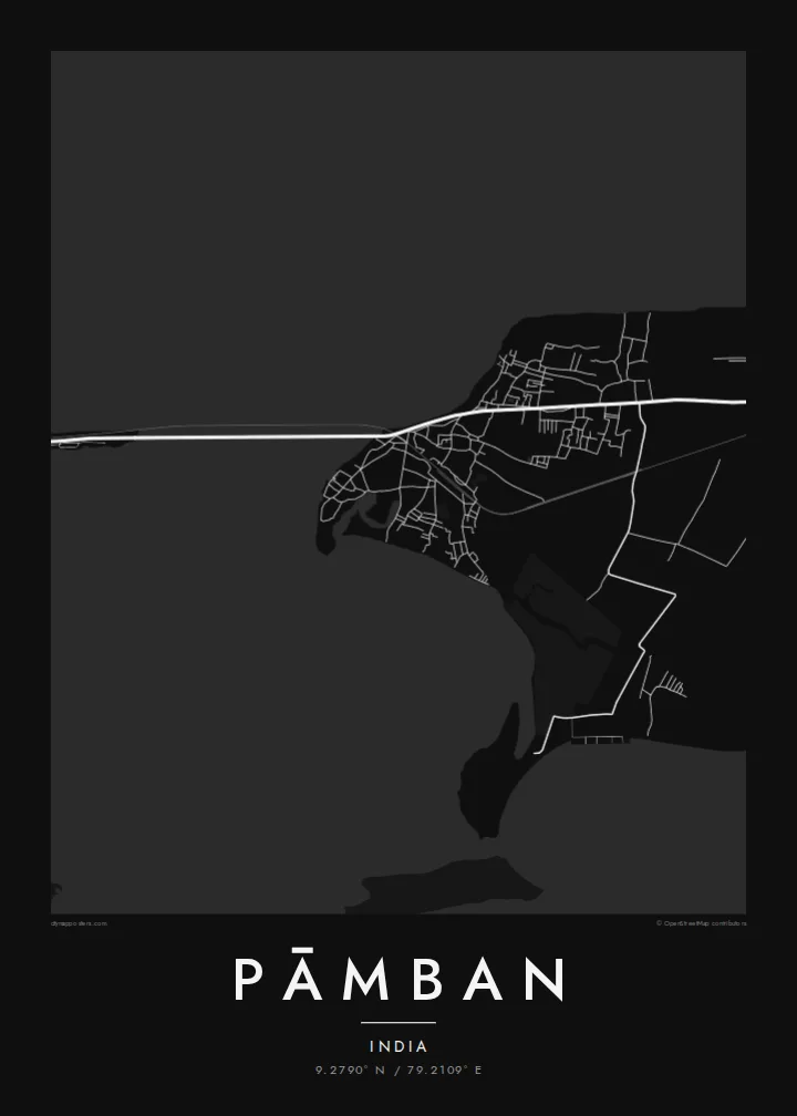
Parallel rail and road bridges cross the Pamban channel to the mainland. On the map they are bold straight lines stretched over open water.
Minimalističen plakat z zemljevidom · Indija
9.2790° N / 79.2109° E
A fishing town at the western tip of Pamban Island, where rail and road bridges span the sea to mainland India.



Eno mesto, pet razpoloženj
Dotaknite se stila, da ga vidite na steni. Vsi stili stanejo enako — natisnjen, uokvirjen ali kot HD datoteke.
 Dejanski slikovni piki · datoteka za tisk 24 × 36″
Ostro za tisk
To je 100-odstotni izrez dejanske datoteke za tisk. Vsak poster — natisnjen, uokvirjen ali prenesen — izrišemo na naših strežnikih pri 300 DPI, do 7,200 × 10,800 slikovnih pik, tako da tudi najmanjše ulice ostanejo ostre na tisku 24 × 36″.
Na steni


Zemljevid
Pāmban sits at the western end of Pamban Island, off the coast of Tamil Nadu, facing the mainland across the Pamban channel. Palk Bay lies on one side and the Gulf of Mannar on the other, and the town occupies a thin strip of sand between them. Streets run close to the shore, and boats line the beaches, since much of local life revolves around fishing.
The town is best known for its bridges. The original Pamban railway bridge opened in 1914 with a lifting span for ships and was for many years one of the most famous engineering works in India. A new vertical-lift rail bridge has since replaced it. It runs alongside the road bridge that links the island to the mainland and on to Rameswaram.
A Pāmban map poster shows a rare composition: two long, straight lines crossing open water, a narrow island edged by sea on both sides, and a small grid of streets pressed against the shore. Few towns show such a clear relationship between land, water and engineering, and it comes through strongly in black and white.
Parallel rail and road bridges cross the Pamban channel to the mainland. On the map they are bold straight lines stretched over open water.
Palk Bay lies to the north and the Gulf of Mannar to the south, so the town sits on a narrow band of land between two bodies of water.
A road and a railway run east along the island toward Rameswaram, forming a single thin spine across the low, sandy landscape.
Naj bo vaš
Dodajte datum, ime ali svoje besedilo, zamenjajte slog, velikost ali usmerjenost.
Brezplačen predogled je nizke ločljivosti in z vodnim žigom. Natisi in HD datoteke so izrisani pri 300 DPI, do 7,200 × 10,800 px, brez vodnega žiga.
Zakaj Pāmban
Pāmban is familiar to anyone who has crossed the bridge on the way to Rameswaram, and to many engineers and railway enthusiasts. The map suits a hallway or office, where the lines of the bridges become an elegant, almost diagrammatic focal point.
Add a title and a subtitle, such as the date of a pilgrimage or a family journey, and adjust the coordinates line. Choose Classic black & white, Noir, Paper, Blueprint or Sand, then download the $9 HD files or order a printed poster.
Naročite poster Pāmban| Velikost tiska | Ločljivost | Datoteke |
|---|---|---|
| 30 × 40 cm11.8 × 15.7″ | 3,543 × 4,724 px | PNG · PDF |
| 29.7 × 42 cm (A3)11.7 × 16.5″ | 3,508 × 4,961 px | PNG · PDF |
| 42 × 59.4 cm (A2)16.5 × 23.4″ | 4,961 × 7,016 px | PNG · PDF |
| 45.7 × 61 cm18 × 24″ | 5,400 × 7,200 px | PNG · PDF |
| 50 × 70 cm19.7 × 27.6″ | 5,906 × 8,268 px | PNG · PDF |
| 61 × 91.4 cm24 × 36″ | 7,200 × 10,800 px | PNG · PDF |
Za primerjavo: brezplačni predogled je širok 900 px, ima vodni žig in je namenjen zaslonom. Datoteke HD imajo do 8-krat večjo ločljivost v vsako smer in se čisto natisnejo v polni velikosti plakata.
Izberite stil na vrhu strani, nato izberite Natisnjen poster — velikost in, če želite, okvir — ali Digitalne HD datoteke. Nakup je zaključen v enem koraku, stran naročila pa se posodobi takoj, ko je plačilo izvedeno.
Natisnjen je na premium mat papir 200 gsm v eni od šestih velikosti, od 30 × 40 cm do 24 × 36″. Natisnjeni posterji se začnejo pri $39, vključno s dostavo.
Da. Izberite okvir iz masivnega lesa v črni, beli, naravni hrastovi ali temni lesni barvi. Ima nezlomljivo steklo in je pripravljen za obešanje. Uokvirjeni posterji se začnejo pri $99, vključno s dostavo.
Dostava je brezplačna v več kot 60 držav. Vsak plakat natisne najbližji od naših tiskarskih partnerjev v več kot 30 državah, običajno pa prispe v 3–7 delovnih dneh. Stanje in sledenje pošiljki lahko spremljate pod »Moja naročila«. Nekaj držav traja 2–5 tednov, tam, kamor še ne dostavljamo, pa vas stran na to opozori, preden plačate.
Pošljite nam fotografijo v 14 dneh po dostavi in ga bomo brezplačno ponovno natisnili ali vam povrnili denar.
Da. V urejevalniku na tej strani spremenite naslov, podnaslov in vrstico s koordinatami po želji ter izberite stil in velikost. Natisnjena, uokvirjena in digitalna naročila vsa uporabijo prav vaš dizajn.
Za $9 dobite PNG datoteke s 300 DPI in PDF datoteke, pripravljene za tisk, v vseh šestih velikostih, brez vodnega žiga, da jih lahko natisnete kjerkoli. Še niste prepričani? Najprej prenesite brezplačen predogled z vodnim žigom.
