Old town grid
The medieval core, planned from the start, forms a compact, regular block of streets. It stands out clearly from the looser layout of the surrounding districts.
Minimalistisk kartposter · Tyskland
53.4699° N / 9.6897° E
A Hanseatic old town on the Este, its compact grid ringed by water just southwest of Hamburg.


En stad, fem stämningar
Tryck på en stil för att se den på väggen. Alla stilar kostar detsamma — tryckt, inramad eller som HD-filer.
 Faktiska pixlar · utskriftsfil 24 × 36″
Knivskarpt tryck
Det här är en 100 % beskuren del av den riktiga utskriftsfilen. Varje poster — tryckt, inramad eller nedladdad — renderas på våra servrar i 300 DPI, upp till 7,200 × 10,800 pixlar, så att även de minsta gatorna förblir skarpa på ett tryck i 24 × 36″.
På väggen


Kartan
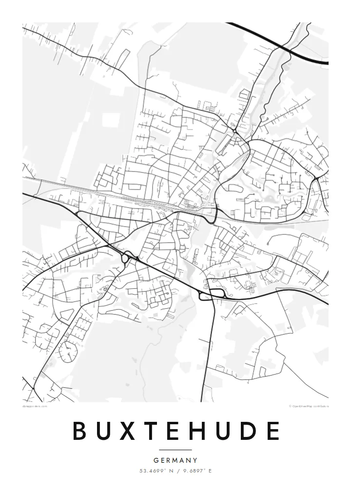
Buxtehude lies on the Este River in Lower Saxony, a short distance southwest of Hamburg. The medieval old town was laid out as a planned settlement in the thirteenth century. On a map it forms a compact, almost rectangular grid of streets bounded by water, with the Fleth canal running through the middle toward the harbour.
The town belonged to the Hanseatic League, and the old harbour, the brick church of St. Petri and the half-timbered houses around the center recall that period. Buxtehude is also known across Germany through the tale of the hare and the hedgehog, which is set on the heath near the town. Germans use its name jokingly for any remote place.
Around the old town, residential districts spread across the flat land at the edge of the Altes Land. Newer streets and railway lines surround the core, and the Este winds north toward the Elbe. A Buxtehude map poster shows the neat historic core within its watery boundary, framed by the looser patterns of a modern commuter town.
The medieval core, planned from the start, forms a compact, regular block of streets. It stands out clearly from the looser layout of the surrounding districts.
A narrow canal lined with old houses runs through the heart of the old town and connects the center to the Este. It is visible even at smaller print sizes.
The river winds along the edge of the old town and continues north through marsh and orchard land toward the Elbe, adding a soft curve to the composition.
Gör den till din
Lägg till ett datum, ett namn eller en egen rad, byt stil, storlek eller orientering.
Den gratis förhandsvisningen har låg upplösning och vattenstämpel. Utskrifter och HD-filer renderas i 300 DPI, upp till 7,200 × 10,800 px, utan vattenstämpel.
Varför Buxtehude
Many people know Buxtehude by name before they ever visit. For those who live there or grew up in the old streets, a map of the town shows that it is a real place, and home.
The title and subtitle can be set to a family name, a street or a special date, and the coordinates can mark an exact spot. Choose one of five styles, from Classic black & white to Blueprint, then download HD files for $9 or order a printed poster.
Beställ Buxtehude-postern| Tryckstorlek | Upplösning | Filer |
|---|---|---|
| 30 × 40 cm11.8 × 15.7″ | 3,543 × 4,724 px | PNG · PDF |
| 29.7 × 42 cm (A3)11.7 × 16.5″ | 3,508 × 4,961 px | PNG · PDF |
| 42 × 59.4 cm (A2)16.5 × 23.4″ | 4,961 × 7,016 px | PNG · PDF |
| 45.7 × 61 cm18 × 24″ | 5,400 × 7,200 px | PNG · PDF |
| 50 × 70 cm19.7 × 27.6″ | 5,906 × 8,268 px | PNG · PDF |
| 61 × 91.4 cm24 × 36″ | 7,200 × 10,800 px | PNG · PDF |
Som jämförelse är den gratis förhandsvisningen 900 px bred, har vattenstämpel och är tänkt för skärm. HD-filerna har upp till 8× högre upplösning i varje riktning och blir skarpa i full posterstorlek.
Välj en stil högst upp på sidan, och välj sedan Tryckt poster — en storlek och, om du vill, en ram — eller Digitala HD-filer. Kassan tar ett steg, och din orderssida uppdateras så snart betalningen har gått igenom.
Den trycks på matt papper av premiumkvalitet, 200 g/m², i en av sex storlekar, från 30 × 40 cm till 24 × 36″. Tryckta postrar kostar från $39, frakt ingår.
Ja. Välj en ram i massivt trä i svart, vitt, naturlig ek eller mörkt trä. Den levereras med splitterskyddat glas och är klar att hänga upp. Inramade postrar kostar från $99, frakt ingår.
Frakten är gratis till över 60 länder. Varje poster trycks av den av våra tryckpartner i över 30 länder som ligger närmast dig och kommer vanligtvis fram inom 3–7 arbetsdagar. Du kan följa status och spårning under Mina beställningar. Några länder tar 2–5 veckor, och om vi inte levererar till ditt land ännu får du veta det på sidan innan du betalar.
Skicka oss ett foto inom 14 dagar efter leverans, så trycker vi om den gratis eller återbetalar dig.
Ja. I redigeraren på den här sidan kan du ändra titeln, undertexten och koordinatraden till vad du vill, och välja stil och storlek. Tryckta, inramade och digitala beställningar använder alltid exakt din design.
För $9 får du PNG-filer i 300 DPI och tryckklara PDF-filer i alla sex storlekar, utan vattenstämpel, att skriva ut var du vill. Inte helt säker än? Ladda ner en gratis förhandsvisning med vattenstämpel först.
