Valley oasis
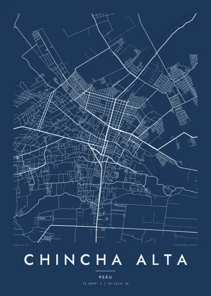
The city sits in an irrigated valley between desert hills and the ocean. The contrast between the dense urban blocks and the surrounding farmland shapes the whole composition.
โปสเตอร์แผนที่มินิมอล · เปรู
13.4099° S / 76.1324° W
A dense valley town on Peru's desert coast, ringed by irrigated fields and vineyards a short distance from the Pacific.



หนึ่งเมือง ห้าอารมณ์
แตะเลือกสไตล์เพื่อดูภาพบนผนัง ทุกสไตล์ราคาเท่ากัน ไม่ว่าจะเป็นแบบพิมพ์ ใส่กรอบ หรือไฟล์ HD
 พิกเซลจริง · ไฟล์พิมพ์ขนาด 24 × 36″
คมชัดระดับงานพิมพ์
นี่คือภาพครอปจากไฟล์พิมพ์จริงแบบ 100% โปสเตอร์ทุกใบ ไม่ว่าจะพิมพ์ ใส่กรอบ หรือดาวน์โหลด จะถูกเรนเดอร์บนเซิร์ฟเวอร์ของเราที่ 300 DPI สูงสุดถึง 7,200 × 10,800 พิกเซล เพื่อให้แม้แต่ซอยเล็กที่สุดยังคมชัดบนงานพิมพ์ขนาด 24 × 36″
บนผนัง


แผนที่
Chincha Alta is the main city of Chincha Province in the Ica Region, on the southern coast of Peru. It sits a few kilometres inland from the Pacific, in a river valley that stands out as a green oasis against the surrounding desert. From above, the urban area is compact, with streets packed densely around the centre and the Pan-American Highway running nearby, linking it to Lima in the north and Ica in the south.
Chincha is widely regarded as the heartland of Afro-Peruvian culture, with music and dance traditions centred on the nearby district of El Carmen. The valley is also known for grape growing and pisco. Before the Spanish arrived, the area was home to the Chincha, a seafaring and trading society later absorbed into the Inca empire.
The Chincha Alta map poster captures the city as a dense island of streets inside a patchwork of fields. Farm roads and irrigation channels create a soft, lined texture around the urban core, and the highway draws a strong stroke across the composition. At a wider scale, the map shows the whole valley reaching toward the coast.
The city sits in an irrigated valley between desert hills and the ocean. The contrast between the dense urban blocks and the surrounding farmland shapes the whole composition.
The main north–south road of the Peruvian coast passes the city, drawing a long straight line through the map and connecting Chincha with Lima and the rest of the coast.
El Carmen, southeast of the city, is known for festivals and music traditions that draw visitors every year. On wider maps it appears as a small settlement among the fields.
ออกแบบในแบบของคุณ
เพิ่มวันที่ ชื่อ หรือข้อความของคุณเอง เปลี่ยนสไตล์ ขนาด หรือแนวภาพได้ตามใจ
ตัวอย่างฟรีมีความละเอียดต่ำและมีลายน้ำ ส่วนงานพิมพ์และไฟล์ HD เรนเดอร์ที่ 300 DPI สูงสุดถึง 7,200 × 10,800 px โดยไม่มีลายน้ำ
ทำไมต้อง Chincha Alta
Chincha Alta speaks to people with family in the valley, to those who travelled south for the music and the pisco, and to Peruvians abroad who want the shape of their town on the wall. The compact centre looks especially good in the larger print sizes.
Personalise the title and subtitle, perhaps with a surname or a festival year, and edit the coordinates line. Choose among five styles, from Noir to Sand. Digital files include six sizes, and printed posters arrive on matte paper with an optional wooden frame.
สั่งซื้อโปสเตอร์ Chincha Alta| ขนาดพิมพ์ | ความละเอียด | ไฟล์ |
|---|---|---|
| 30 × 40 cm11.8 × 15.7″ | 3,543 × 4,724 px | PNG · PDF |
| 29.7 × 42 cm (A3)11.7 × 16.5″ | 3,508 × 4,961 px | PNG · PDF |
| 42 × 59.4 cm (A2)16.5 × 23.4″ | 4,961 × 7,016 px | PNG · PDF |
| 45.7 × 61 cm18 × 24″ | 5,400 × 7,200 px | PNG · PDF |
| 50 × 70 cm19.7 × 27.6″ | 5,906 × 8,268 px | PNG · PDF |
| 61 × 91.4 cm24 × 36″ | 7,200 × 10,800 px | PNG · PDF |
เพื่อการเปรียบเทียบ ตัวอย่างฟรีกว้าง 900 px มีลายน้ำ และเหมาะสำหรับดูบนหน้าจอ ส่วนไฟล์ HD มีความละเอียดสูงกว่าถึง 8 เท่าในแต่ละด้าน และพิมพ์ได้คมชัดเต็มขนาดโปสเตอร์
เลือกสไตล์ที่ด้านบนของหน้า จากนั้นเลือก Printed Poster — กำหนดขนาดและกรอบตามต้องการ — หรือเลือก Digital HD Files การชำระเงินทำได้ในขั้นตอนเดียว และหน้าคำสั่งซื้อของคุณจะอัปเดตทันทีที่การชำระเงินสำเร็จ
พิมพ์บนกระดาษด้าน 200 แกรมเกรดพรีเมียม มีให้เลือก 6 ขนาด ตั้งแต่ 30 × 40 ซม. ถึง 24 × 36″ โปสเตอร์แบบพิมพ์เริ่มต้นที่ $39 รวมค่าจัดส่งแล้ว
ได้ เลือกกรอบไม้แท้ได้ทั้งสีดำ สีขาว โอ๊กธรรมชาติ หรือไม้เข้ม มาพร้อมกระจกนิรภัยกันแตกและพร้อมแขวนได้ทันที โปสเตอร์พร้อมกรอบเริ่มต้นที่ $99 รวมค่าจัดส่งแล้ว
จัดส่งฟรีไปกว่า 60 ประเทศ โปสเตอร์แต่ละใบพิมพ์โดยพาร์ทเนอร์การพิมพ์ที่อยู่ใกล้คุณที่สุดจากกว่า 30 ประเทศ และมักจะถึงมือคุณภายใน 3–7 วันทำการ คุณสามารถติดตามสถานะและเลขพัสดุได้ที่ "คำสั่งซื้อของฉัน" บางประเทศใช้เวลา 2–5 สัปดาห์ และหากเรายังไม่จัดส่งไปยังประเทศของคุณ เว็บไซต์จะแจ้งให้ทราบก่อนชำระเงิน
ส่งภาพถ่ายมาให้เราภายใน 14 วันหลังได้รับสินค้า เราจะพิมพ์ใหม่ให้ฟรีหรือคืนเงินให้
ได้ ในตัวแก้ไขบนหน้านี้ คุณสามารถเปลี่ยนชื่อเรื่อง ข้อความรอง และบรรทัดพิกัดได้ตามต้องการ พร้อมเลือกสไตล์และขนาด ไม่ว่าจะเป็นแบบพิมพ์ ใส่กรอบ หรือไฟล์ดิจิทัล ทุกคำสั่งซื้อจะใช้ดีไซน์ของคุณเป๊ะ
ในราคา $9 คุณจะได้ไฟล์ PNG ความละเอียด 300 DPI และไฟล์ PDF พร้อมพิมพ์ครบทั้ง 6 ขนาด ไม่มีลายน้ำ นำไปพิมพ์ที่ไหนก็ได้ ยังไม่แน่ใจ? ดาวน์โหลดตัวอย่างแบบมีลายน้ำฟรีก่อนได้
