Halterner Stausee
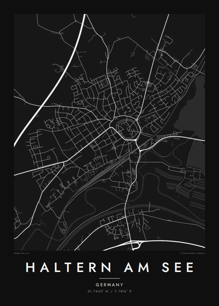
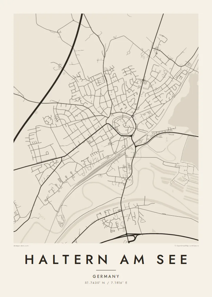
The reservoir east of the town spreads into several arms, its irregular shoreline and sandy beach forming the most recognisable shape on the map.
โปสเตอร์แผนที่มินิมอล · เยอรมนี
51.7430° N / 7.1816° E
A town framed by reservoirs, pine forest and the Lippe, where water and woodland outline the streets on every side.



หนึ่งเมือง ห้าอารมณ์
แตะเลือกสไตล์เพื่อดูภาพบนผนัง ทุกสไตล์ราคาเท่ากัน ไม่ว่าจะเป็นแบบพิมพ์ ใส่กรอบ หรือไฟล์ HD
 พิกเซลจริง · ไฟล์พิมพ์ขนาด 24 × 36″
คมชัดระดับงานพิมพ์
นี่คือภาพครอปจากไฟล์พิมพ์จริงแบบ 100% โปสเตอร์ทุกใบ ไม่ว่าจะพิมพ์ ใส่กรอบ หรือดาวน์โหลด จะถูกเรนเดอร์บนเซิร์ฟเวอร์ของเราที่ 300 DPI สูงสุดถึง 7,200 × 10,800 พิกเซล เพื่อให้แม้แต่ซอยเล็กที่สุดยังคมชัดบนงานพิมพ์ขนาด 24 × 36″
บนผนัง


แผนที่
Haltern am See lies on the northern edge of the Ruhr area in North Rhine-Westphalia, where the industrial region gives way to the woods and heaths of the Münsterland. Its name refers to the Halterner Stausee, a reservoir built around 1930 that supplies drinking water to much of the Ruhr and doubles as a lake for swimming and sailing. The suffix am See was added to the town's name in 2001.
The town also has deep roots. Excavations have uncovered camps from the Roman campaigns in Germania around the turn of the millennium, and the LWL Roman Museum in Haltern presents the finds. The river Lippe, which the Roman army used as a route inland, still runs past the south of the town alongside the Wesel-Datteln Canal.
A Haltern am See map poster shows the lakes, the river and canal, and the dense forest of the Hohe Mark nature park wrapped around a compact town centre. With so much water and woodland in the frame, the print has a light, open feel, quite different from the dense cities further south in the Ruhr.
The reservoir east of the town spreads into several arms, its irregular shoreline and sandy beach forming the most recognisable shape on the map.
The river and the Wesel-Datteln Canal run side by side along the south of the town, one winding and one ruler-straight, a striking pairing on the poster.
Extensive pine and mixed woodland surrounds Haltern as part of the Hohe Mark nature park, leaving large quiet areas in the composition broken only by paths and lanes.
ออกแบบในแบบของคุณ
เพิ่มวันที่ ชื่อ หรือข้อความของคุณเอง เปลี่ยนสไตล์ ขนาด หรือแนวภาพได้ตามใจ
ตัวอย่างฟรีมีความละเอียดต่ำและมีลายน้ำ ส่วนงานพิมพ์และไฟล์ HD เรนเดอร์ที่ 300 DPI สูงสุดถึง 7,200 × 10,800 px โดยไม่มีลายน้ำ
ทำไมต้อง Haltern am See
Haltern am See is where many Ruhr families spend summer weekends, and where others choose to settle for the lakes and woods. A map poster of the town captures that balance of water, forest and small-town streets in a single calm image.
Personalise the title and subtitle, add a date or a favourite lakeside spot, and edit the coordinates line. Choose from five styles, Classic black and white, Noir, Paper, Blueprint and Sand; Blueprint makes the lakes and canal stand out particularly well.
สั่งซื้อโปสเตอร์ Haltern am See| ขนาดพิมพ์ | ความละเอียด | ไฟล์ |
|---|---|---|
| 30 × 40 cm11.8 × 15.7″ | 3,543 × 4,724 px | PNG · PDF |
| 29.7 × 42 cm (A3)11.7 × 16.5″ | 3,508 × 4,961 px | PNG · PDF |
| 42 × 59.4 cm (A2)16.5 × 23.4″ | 4,961 × 7,016 px | PNG · PDF |
| 45.7 × 61 cm18 × 24″ | 5,400 × 7,200 px | PNG · PDF |
| 50 × 70 cm19.7 × 27.6″ | 5,906 × 8,268 px | PNG · PDF |
| 61 × 91.4 cm24 × 36″ | 7,200 × 10,800 px | PNG · PDF |
เพื่อการเปรียบเทียบ ตัวอย่างฟรีกว้าง 900 px มีลายน้ำ และเหมาะสำหรับดูบนหน้าจอ ส่วนไฟล์ HD มีความละเอียดสูงกว่าถึง 8 เท่าในแต่ละด้าน และพิมพ์ได้คมชัดเต็มขนาดโปสเตอร์
เลือกสไตล์ที่ด้านบนของหน้า จากนั้นเลือก Printed Poster — กำหนดขนาดและกรอบตามต้องการ — หรือเลือก Digital HD Files การชำระเงินทำได้ในขั้นตอนเดียว และหน้าคำสั่งซื้อของคุณจะอัปเดตทันทีที่การชำระเงินสำเร็จ
พิมพ์บนกระดาษด้าน 200 แกรมเกรดพรีเมียม มีให้เลือก 6 ขนาด ตั้งแต่ 30 × 40 ซม. ถึง 24 × 36″ โปสเตอร์แบบพิมพ์เริ่มต้นที่ $39 รวมค่าจัดส่งแล้ว
ได้ เลือกกรอบไม้แท้ได้ทั้งสีดำ สีขาว โอ๊กธรรมชาติ หรือไม้เข้ม มาพร้อมกระจกนิรภัยกันแตกและพร้อมแขวนได้ทันที โปสเตอร์พร้อมกรอบเริ่มต้นที่ $99 รวมค่าจัดส่งแล้ว
จัดส่งฟรีไปกว่า 60 ประเทศ โปสเตอร์แต่ละใบพิมพ์โดยพาร์ทเนอร์การพิมพ์ที่อยู่ใกล้คุณที่สุดจากกว่า 30 ประเทศ และมักจะถึงมือคุณภายใน 3–7 วันทำการ คุณสามารถติดตามสถานะและเลขพัสดุได้ที่ "คำสั่งซื้อของฉัน" บางประเทศใช้เวลา 2–5 สัปดาห์ และหากเรายังไม่จัดส่งไปยังประเทศของคุณ เว็บไซต์จะแจ้งให้ทราบก่อนชำระเงิน
ส่งภาพถ่ายมาให้เราภายใน 14 วันหลังได้รับสินค้า เราจะพิมพ์ใหม่ให้ฟรีหรือคืนเงินให้
ได้ ในตัวแก้ไขบนหน้านี้ คุณสามารถเปลี่ยนชื่อเรื่อง ข้อความรอง และบรรทัดพิกัดได้ตามต้องการ พร้อมเลือกสไตล์และขนาด ไม่ว่าจะเป็นแบบพิมพ์ ใส่กรอบ หรือไฟล์ดิจิทัล ทุกคำสั่งซื้อจะใช้ดีไซน์ของคุณเป๊ะ
ในราคา $9 คุณจะได้ไฟล์ PNG ความละเอียด 300 DPI และไฟล์ PDF พร้อมพิมพ์ครบทั้ง 6 ขนาด ไม่มีลายน้ำ นำไปพิมพ์ที่ไหนก็ได้ ยังไม่แน่ใจ? ดาวน์โหลดตัวอย่างแบบมีลายน้ำฟรีก่อนได้
