Sebou meanders
The river curves along the northern edge of the city in broad loops, with the port and quays along the bank marking the line between water and streets.
โปสเตอร์แผนที่มินิมอล · โมร็อกโก
34.2610° N / 6.5802° W
A river port on the looping Sebou near the Atlantic, with a planned French-era centre and a coastal lagoon to the south.




หนึ่งเมือง ห้าอารมณ์
แตะเลือกสไตล์เพื่อดูภาพบนผนัง ทุกสไตล์ราคาเท่ากัน ไม่ว่าจะเป็นแบบพิมพ์ ใส่กรอบ หรือไฟล์ HD
 พิกเซลจริง · ไฟล์พิมพ์ขนาด 24 × 36″
คมชัดระดับงานพิมพ์
นี่คือภาพครอปจากไฟล์พิมพ์จริงแบบ 100% โปสเตอร์ทุกใบ ไม่ว่าจะพิมพ์ ใส่กรอบ หรือดาวน์โหลด จะถูกเรนเดอร์บนเซิร์ฟเวอร์ของเราที่ 300 DPI สูงสุดถึง 7,200 × 10,800 พิกเซล เพื่อให้แม้แต่ซอยเล็กที่สุดยังคมชัดบนงานพิมพ์ขนาด 24 × 36″
บนผนัง


แผนที่
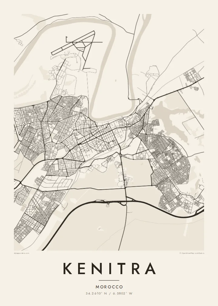
Kenitra lies on the south bank of the Sebou River, a few kilometres upstream from its mouth on the Atlantic coast. The river loops in wide meanders past the city, and the port quays sit along its bank. On the map, the Sebou forms a strong curving boundary along the northern edge of the built area.
The centre was laid out by the French in the early twentieth century, and its regular pattern of avenues and roundabouts contrasts with newer districts spreading inland. Toward the coast, the resort of Mehdia sits at the river mouth beside an old kasbah, and to the south a lagoon and wetland reserve at Sidi Boughaba lie between the dunes and the forest.
The modern city began as a French military post and port in the early twentieth century, was known as Port Lyautey from 1932, and took back the name Kenitra after independence. It is now an industrial and university city in the Rabat-Salé-Kénitra region. A Kenitra map poster brings the river bends, the planned centre and the nearby coast together.
The river curves along the northern edge of the city in broad loops, with the port and quays along the bank marking the line between water and streets.
Straight avenues and radiating roads in the older centre reflect the French plan, forming a clear, orderly core within the looser newer districts.
At the mouth of the Sebou, the beach town of Mehdia and its hilltop kasbah face the Atlantic, with the Sidi Boughaba lagoon lying just to the south.
ออกแบบในแบบของคุณ
เพิ่มวันที่ ชื่อ หรือข้อความของคุณเอง เปลี่ยนสไตล์ ขนาด หรือแนวภาพได้ตามใจ
ตัวอย่างฟรีมีความละเอียดต่ำและมีลายน้ำ ส่วนงานพิมพ์และไฟล์ HD เรนเดอร์ที่ 300 DPI สูงสุดถึง 7,200 × 10,800 px โดยไม่มีลายน้ำ
ทำไมต้อง Kenitra
People from Kenitra often move to Rabat, Casablanca or abroad, and a map of the river city is a simple way to keep its streets in view. The combination of river loops and an ordered centre makes a composition that is both personal and graphic.
Set your own title, subtitle and coordinates line, and pick one of five styles; Sand suits the Atlantic coast, while Classic black & white stays crisp. The $9 download includes six sizes as PNG and PDF, and printed posters ship from partners in over 30 countries.
สั่งซื้อโปสเตอร์ Kenitra| ขนาดพิมพ์ | ความละเอียด | ไฟล์ |
|---|---|---|
| 30 × 40 cm (11.8 × 15.7″) | 3,543 × 4,724 px | PNG · PDF |
| 29.7 × 42 cm (A3, 11.7 × 16.5″) | 3,508 × 4,961 px | PNG · PDF |
| 42 × 59.4 cm (A2, 16.5 × 23.4″) | 4,961 × 7,016 px | PNG · PDF |
| 45.7 × 61 cm (18 × 24″) | 5,400 × 7,200 px | PNG · PDF |
| 50 × 70 cm (19.7 × 27.6″) | 5,906 × 8,268 px | PNG · PDF |
| 61 × 91.4 cm (24 × 36″) | 7,200 × 10,800 px | PNG · PDF |
เพื่อการเปรียบเทียบ ตัวอย่างฟรีกว้าง 900 px มีลายน้ำ และเหมาะสำหรับดูบนหน้าจอ ส่วนไฟล์ HD มีความละเอียดสูงกว่าถึง 8 เท่าในแต่ละด้าน และพิมพ์ได้คมชัดเต็มขนาดโปสเตอร์
เลือกสไตล์ที่ด้านบนของหน้า จากนั้นเลือก Printed Poster — กำหนดขนาดและกรอบตามต้องการ — หรือเลือก Digital HD Files การชำระเงินทำได้ในขั้นตอนเดียว และหน้าคำสั่งซื้อของคุณจะอัปเดตทันทีที่การชำระเงินสำเร็จ
พิมพ์บนกระดาษด้าน 200 แกรมเกรดพรีเมียม มีให้เลือก 6 ขนาด ตั้งแต่ 30 × 40 ซม. ถึง 24 × 36″ โปสเตอร์แบบพิมพ์เริ่มต้นที่ $39 รวมค่าจัดส่งแล้ว
ได้ เลือกกรอบไม้แท้ได้ทั้งสีดำ สีขาว โอ๊กธรรมชาติ หรือไม้เข้ม มาพร้อมกระจกนิรภัยกันแตกและพร้อมแขวนได้ทันที โปสเตอร์พร้อมกรอบเริ่มต้นที่ $99 รวมค่าจัดส่งแล้ว
จัดส่งฟรีทั่วโลก โปสเตอร์แต่ละใบพิมพ์โดยพาร์ตเนอร์การพิมพ์ที่อยู่ใกล้คุณที่สุดจากกว่า 30 ประเทศ และมักจะถึงมือภายใน 3–7 วันทำการ คุณสามารถติดตามสถานะและเลขพัสดุได้ที่ "คำสั่งซื้อของฉัน" บางประเทศใช้เวลา 2–5 สัปดาห์ และหากประเทศไหนที่เรายังไม่จัดส่งไป เว็บไซต์จะแจ้งให้ทราบก่อนชำระเงิน
ส่งภาพถ่ายมาให้เราภายใน 14 วันหลังได้รับสินค้า เราจะพิมพ์ใหม่ให้ฟรีหรือคืนเงินให้
ได้ ในตัวแก้ไขบนหน้านี้ คุณสามารถเปลี่ยนชื่อเรื่อง ข้อความรอง และบรรทัดพิกัดได้ตามต้องการ พร้อมเลือกสไตล์และขนาด ไม่ว่าจะเป็นแบบพิมพ์ ใส่กรอบ หรือไฟล์ดิจิทัล ทุกคำสั่งซื้อจะใช้ดีไซน์ของคุณเป๊ะ
ในราคา $9 คุณจะได้ไฟล์ PNG ความละเอียด 300 DPI และไฟล์ PDF พร้อมพิมพ์ครบทั้ง 6 ขนาด ไม่มีลายน้ำ นำไปพิมพ์ที่ไหนก็ได้ ยังไม่แน่ใจ? ดาวน์โหลดตัวอย่างแบบมีลายน้ำฟรีก่อนได้
