Nieuwe Waterweg
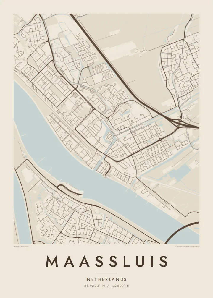
The wide shipping channel runs along the town's southern side, one of the busiest waterways in Europe, and forms a bold band across the bottom of the poster.
โปสเตอร์แผนที่มินิมอล · เนเธอร์แลนด์
51.9233° N / 4.2500° E
A harbour town on the Nieuwe Waterweg, with an old sluice-side core, straight dikes and polders opening behind the river.


หนึ่งเมือง ห้าอารมณ์
แตะเลือกสไตล์เพื่อดูภาพบนผนัง ทุกสไตล์ราคาเท่ากัน ไม่ว่าจะเป็นแบบพิมพ์ ใส่กรอบ หรือไฟล์ HD
 พิกเซลจริง · ไฟล์พิมพ์ขนาด 24 × 36″
คมชัดระดับงานพิมพ์
นี่คือภาพครอปจากไฟล์พิมพ์จริงแบบ 100% โปสเตอร์ทุกใบ ไม่ว่าจะพิมพ์ ใส่กรอบ หรือดาวน์โหลด จะถูกเรนเดอร์บนเซิร์ฟเวอร์ของเราที่ 300 DPI สูงสุดถึง 7,200 × 10,800 พิกเซล เพื่อให้แม้แต่ซอยเล็กที่สุดยังคมชัดบนงานพิมพ์ขนาด 24 × 36″
บนผนัง


แผนที่
Maassluis sits on the north bank of the Nieuwe Waterweg, the wide shipping channel that links Rotterdam to the North Sea. From above, the river forms a broad, dark band along the southern edge of the town. The old harbour cuts inland from it, surrounded by the tight streets of the historic centre, and the rest of the town extends north into the flat Dutch polder landscape.
The name refers to the sluice that once let water from the polders drain into the river. Water management still sets the pattern here, with dikes, ditches and straight drainage lines across the surrounding land. The town has long been associated with tugboats and maritime work, and ships moving to and from Rotterdam pass close to its quays.
A Maassluis map poster shows the contrast between that major waterway and the small, careful street network behind it. The harbour basin, the dike roads and the geometric polder edges produce a map with clean straight lines and one strong horizontal river. It is Dutch landscape design seen from above.
The wide shipping channel runs along the town's southern side, one of the busiest waterways in Europe, and forms a bold band across the bottom of the poster.
A narrow basin reaches inland from the river into the historic centre. The oldest streets and quays cluster close around it in a small, dense pattern.
North of the built-up area, straight ditches and roads divide the reclaimed land into long rectangles, a pattern typical of South Holland that looks crisp in black and white.
ออกแบบในแบบของคุณ
เพิ่มวันที่ ชื่อ หรือข้อความของคุณเอง เปลี่ยนสไตล์ ขนาด หรือแนวภาพได้ตามใจ
ตัวอย่างฟรีมีความละเอียดต่ำและมีลายน้ำ ส่วนงานพิมพ์และไฟล์ HD เรนเดอร์ที่ 300 DPI สูงสุดถึง 7,200 × 10,800 px โดยไม่มีลายน้ำ
ทำไมต้อง Maassluis
If you have lived by the Waterweg and watched ships pass behind the dike, this map will look familiar. It also appeals to anyone who likes how the Dutch have drawn their land with rulers and water.
Personalise the title, subtitle and coordinates, perhaps with a harbour name or the year of a move. The five styles range from Classic black & white to Noir, which gives the river a deep, dark presence.
สั่งซื้อโปสเตอร์ Maassluis| ขนาดพิมพ์ | ความละเอียด | ไฟล์ |
|---|---|---|
| 30 × 40 cm (11.8 × 15.7″) | 3,543 × 4,724 px | PNG · PDF |
| 29.7 × 42 cm (A3, 11.7 × 16.5″) | 3,508 × 4,961 px | PNG · PDF |
| 42 × 59.4 cm (A2, 16.5 × 23.4″) | 4,961 × 7,016 px | PNG · PDF |
| 45.7 × 61 cm (18 × 24″) | 5,400 × 7,200 px | PNG · PDF |
| 50 × 70 cm (19.7 × 27.6″) | 5,906 × 8,268 px | PNG · PDF |
| 61 × 91.4 cm (24 × 36″) | 7,200 × 10,800 px | PNG · PDF |
เพื่อการเปรียบเทียบ ตัวอย่างฟรีกว้าง 900 px มีลายน้ำ และเหมาะสำหรับดูบนหน้าจอ ส่วนไฟล์ HD มีความละเอียดสูงกว่าถึง 8 เท่าในแต่ละด้าน และพิมพ์ได้คมชัดเต็มขนาดโปสเตอร์
เลือกสไตล์ที่ด้านบนของหน้า จากนั้นเลือก Printed Poster — กำหนดขนาดและกรอบตามต้องการ — หรือเลือก Digital HD Files การชำระเงินทำได้ในขั้นตอนเดียว และหน้าคำสั่งซื้อของคุณจะอัปเดตทันทีที่การชำระเงินสำเร็จ
พิมพ์บนกระดาษด้าน 200 แกรมเกรดพรีเมียม มีให้เลือก 6 ขนาด ตั้งแต่ 30 × 40 ซม. ถึง 24 × 36″ โปสเตอร์แบบพิมพ์เริ่มต้นที่ $39 รวมค่าจัดส่งแล้ว
ได้ เลือกกรอบไม้แท้ได้ทั้งสีดำ สีขาว โอ๊กธรรมชาติ หรือไม้เข้ม มาพร้อมกระจกนิรภัยกันแตกและพร้อมแขวนได้ทันที โปสเตอร์พร้อมกรอบเริ่มต้นที่ $99 รวมค่าจัดส่งแล้ว
จัดส่งฟรีทั่วโลก โปสเตอร์แต่ละใบพิมพ์โดยพาร์ตเนอร์การพิมพ์ที่อยู่ใกล้คุณที่สุดจากกว่า 30 ประเทศ และมักจะถึงมือภายใน 3–7 วันทำการ คุณสามารถติดตามสถานะและเลขพัสดุได้ที่ "คำสั่งซื้อของฉัน" บางประเทศใช้เวลา 2–5 สัปดาห์ และหากประเทศไหนที่เรายังไม่จัดส่งไป เว็บไซต์จะแจ้งให้ทราบก่อนชำระเงิน
ส่งภาพถ่ายมาให้เราภายใน 14 วันหลังได้รับสินค้า เราจะพิมพ์ใหม่ให้ฟรีหรือคืนเงินให้
ได้ ในตัวแก้ไขบนหน้านี้ คุณสามารถเปลี่ยนชื่อเรื่อง ข้อความรอง และบรรทัดพิกัดได้ตามต้องการ พร้อมเลือกสไตล์และขนาด ไม่ว่าจะเป็นแบบพิมพ์ ใส่กรอบ หรือไฟล์ดิจิทัล ทุกคำสั่งซื้อจะใช้ดีไซน์ของคุณเป๊ะ
ในราคา $9 คุณจะได้ไฟล์ PNG ความละเอียด 300 DPI และไฟล์ PDF พร้อมพิมพ์ครบทั้ง 6 ขนาด ไม่มีลายน้ำ นำไปพิมพ์ที่ไหนก็ได้ ยังไม่แน่ใจ? ดาวน์โหลดตัวอย่างแบบมีลายน้ำฟรีก่อนได้
