Road to Antakya
The main roads running south towards Antakya give the map its direction, tying the compact town grid to the larger city just beyond the frame.
โปสเตอร์แผนที่มินิมอล · ตุรกี
36.2353° N / 36.2146° E
A compact Hatay town of short streets and scattered blocks, set among farmland on the northern approach to Antakya


หนึ่งเมือง ห้าอารมณ์
แตะเลือกสไตล์เพื่อดูภาพบนผนัง ทุกสไตล์ราคาเท่ากัน ไม่ว่าจะเป็นแบบพิมพ์ ใส่กรอบ หรือไฟล์ HD
 พิกเซลจริง · ไฟล์พิมพ์ขนาด 24 × 36″
คมชัดระดับงานพิมพ์
นี่คือภาพครอปจากไฟล์พิมพ์จริงแบบ 100% โปสเตอร์ทุกใบ ไม่ว่าจะพิมพ์ ใส่กรอบ หรือดาวน์โหลด จะถูกเรนเดอร์บนเซิร์ฟเวอร์ของเราที่ 300 DPI สูงสุดถึง 7,200 × 10,800 พิกเซล เพื่อให้แม้แต่ซอยเล็กที่สุดยังคมชัดบนงานพิมพ์ขนาด 24 × 36″
บนผนัง


แผนที่
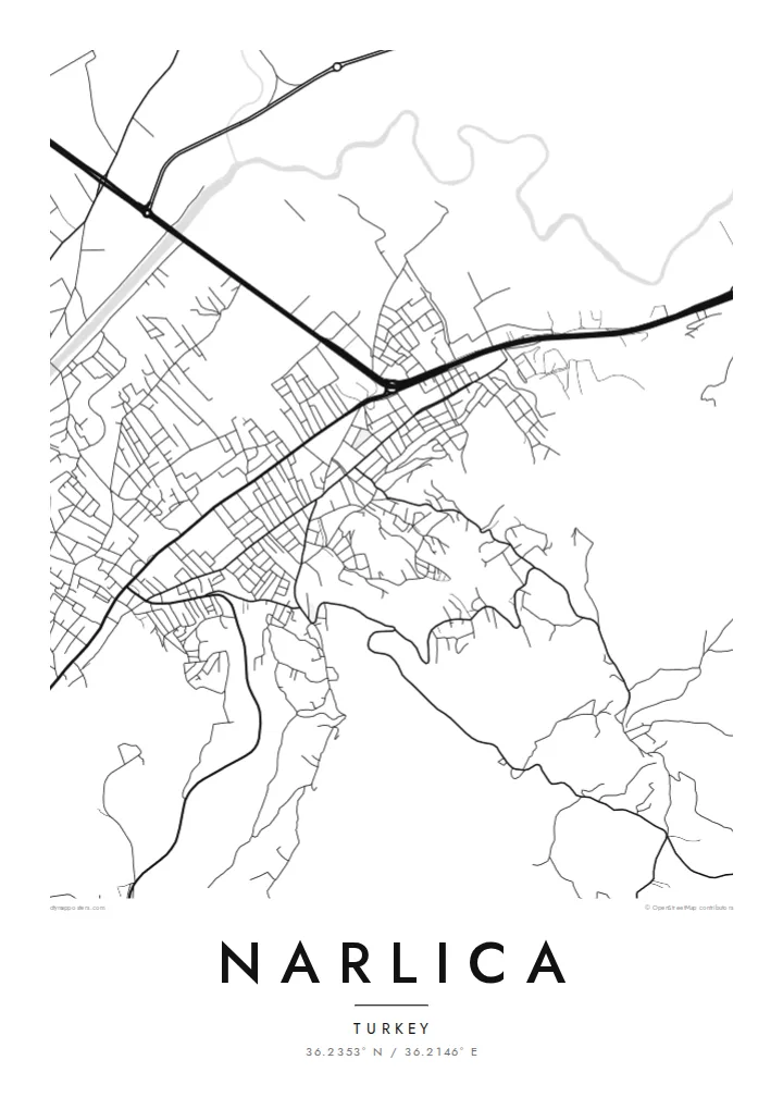
Narlıca sits in the province of Hatay, close to the northern edge of Antakya, in the far south of Turkey. From above, the town is a loose cluster of blocks and short connecting streets. There are no grand avenues. The pattern grows outward from a few main roads that link it to the regional capital and to the countryside around it.
Hatay lies in a corridor between mountains and the Mediterranean, and that setting shapes the wider map. Higher ground rises to the west. Flatter, cultivated land opens out towards the plain. At poster scale, Narlıca's streets are dense in the centre and thin out into field boundaries and farm tracks at the edges, so the line between town and land is easy to follow.
A Narlıca map poster is a way to hold on to a specific place in a region that has seen great change in recent years. Rendered in fine black lines, the street network becomes a quiet record of where houses, shops and daily routes stand. It is a small, personal map, closer in feeling to a family document than to a tourist plan.
The main roads running south towards Antakya give the map its direction, tying the compact town grid to the larger city just beyond the frame.
Near the centre, short streets and tightly packed blocks form a darker patch of line work that stands out clearly against the open land around it.
On the outskirts, the streets give way to straight field boundaries and tracks, a quieter texture that frames the settlement on every side.
ออกแบบในแบบของคุณ
เพิ่มวันที่ ชื่อ หรือข้อความของคุณเอง เปลี่ยนสไตล์ ขนาด หรือแนวภาพได้ตามใจ
ตัวอย่างฟรีมีความละเอียดต่ำและมีลายน้ำ ส่วนงานพิมพ์และไฟล์ HD เรนเดอร์ที่ 300 DPI สูงสุดถึง 7,200 × 10,800 px โดยไม่มีลายน้ำ
ทำไมต้อง Narlıca
People from Narlıca, and families with roots in Hatay, often want something that holds the shape of home. A simple street map does that without sentiment. It shows the familiar route to the market or school, and the place names on it stay the same whoever is looking.
You can add your own title, a subtitle and a coordinates line, perhaps with a date that matters to you. Choose from five styles: Classic black & white, Noir, Paper, Blueprint or Sand. It is available as an HD digital file or as a printed poster.
สั่งซื้อโปสเตอร์ Narlıca| ขนาดพิมพ์ | ความละเอียด | ไฟล์ |
|---|---|---|
| 30 × 40 cm (11.8 × 15.7″) | 3,543 × 4,724 px | PNG · PDF |
| 29.7 × 42 cm (A3, 11.7 × 16.5″) | 3,508 × 4,961 px | PNG · PDF |
| 42 × 59.4 cm (A2, 16.5 × 23.4″) | 4,961 × 7,016 px | PNG · PDF |
| 45.7 × 61 cm (18 × 24″) | 5,400 × 7,200 px | PNG · PDF |
| 50 × 70 cm (19.7 × 27.6″) | 5,906 × 8,268 px | PNG · PDF |
| 61 × 91.4 cm (24 × 36″) | 7,200 × 10,800 px | PNG · PDF |
เพื่อการเปรียบเทียบ ตัวอย่างฟรีกว้าง 900 px มีลายน้ำ และเหมาะสำหรับดูบนหน้าจอ ส่วนไฟล์ HD มีความละเอียดสูงกว่าถึง 8 เท่าในแต่ละด้าน และพิมพ์ได้คมชัดเต็มขนาดโปสเตอร์
เลือกสไตล์ที่ด้านบนของหน้า จากนั้นเลือก Printed Poster — กำหนดขนาดและกรอบตามต้องการ — หรือเลือก Digital HD Files การชำระเงินทำได้ในขั้นตอนเดียว และหน้าคำสั่งซื้อของคุณจะอัปเดตทันทีที่การชำระเงินสำเร็จ
พิมพ์บนกระดาษด้าน 200 แกรมเกรดพรีเมียม มีให้เลือก 6 ขนาด ตั้งแต่ 30 × 40 ซม. ถึง 24 × 36″ โปสเตอร์แบบพิมพ์เริ่มต้นที่ {printFrom} รวมค่าจัดส่งแล้ว
ได้ เลือกกรอบไม้แท้ได้ทั้งสีดำ สีขาว โอ๊กธรรมชาติ หรือไม้เข้ม มาพร้อมกระจกนิรภัยกันแตกและพร้อมแขวนได้ทันที โปสเตอร์พร้อมกรอบเริ่มต้นที่ {framedFrom} รวมค่าจัดส่งแล้ว
จัดส่งฟรีทั่วโลก โปสเตอร์แต่ละใบจะพิมพ์โดยพันธมิตรโรงพิมพ์ที่ใกล้ที่สุดจากกว่า 30 ประเทศ และมักจะถึงมือคุณภายใน 3–7 วันทำการ ตรวจสอบสถานะและติดตามพัสดุได้ที่ My Orders
ส่งภาพถ่ายมาให้เราภายใน 14 วันหลังได้รับสินค้า เราจะพิมพ์ใหม่ให้ฟรีหรือคืนเงินให้
ได้ ในตัวแก้ไขบนหน้านี้ คุณสามารถเปลี่ยนชื่อเรื่อง ข้อความรอง และบรรทัดพิกัดได้ตามต้องการ พร้อมเลือกสไตล์และขนาด ไม่ว่าจะเป็นแบบพิมพ์ ใส่กรอบ หรือไฟล์ดิจิทัล ทุกคำสั่งซื้อจะใช้ดีไซน์ของคุณเป๊ะ
ในราคา $9 คุณจะได้ไฟล์ PNG ความละเอียด 300 DPI และไฟล์ PDF พร้อมพิมพ์ครบทั้ง 6 ขนาด ไม่มีลายน้ำ นำไปพิมพ์ที่ไหนก็ได้ ยังไม่แน่ใจ? ดาวน์โหลดตัวอย่างแบบมีลายน้ำฟรีก่อนได้
