Magdalena peninsula
A rounded, wooded headland marks the mouth of the bay. Paths loop around it and the palace sits at its centre, an unmistakable knot of green between the harbour and the beaches.
โปสเตอร์แผนที่มินิมอล · สเปน
43.4659° N / 3.8049° W
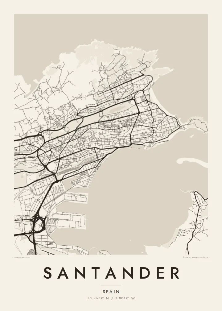
A long waterfront city stretched along the north shore of a sheltered bay, ending in a wooded peninsula and open Atlantic beaches.




หนึ่งเมือง ห้าอารมณ์
แตะเลือกสไตล์เพื่อดูภาพบนผนัง ทุกสไตล์ราคาเท่ากัน ไม่ว่าจะเป็นแบบพิมพ์ ใส่กรอบ หรือไฟล์ HD
 พิกเซลจริง · ไฟล์พิมพ์ขนาด 24 × 36″
คมชัดระดับงานพิมพ์
นี่คือภาพครอปจากไฟล์พิมพ์จริงแบบ 100% โปสเตอร์ทุกใบ ไม่ว่าจะพิมพ์ ใส่กรอบ หรือดาวน์โหลด จะถูกเรนเดอร์บนเซิร์ฟเวอร์ของเราที่ 300 DPI สูงสุดถึง 7,200 × 10,800 พิกเซล เพื่อให้แม้แต่ซอยเล็กที่สุดยังคมชัดบนงานพิมพ์ขนาด 24 × 36″
บนผนัง


แผนที่
Seen from above, Santander runs east to west along the north side of the Bay of Santander, the capital of Cantabria facing south across calm water rather than out to the open sea. The centre follows the shoreline in a narrow band. Promenades, docks and the port line the edge, and the streets behind climb quickly into hills that close the city in on its northern side.
At the eastern end the land turns into the Magdalena peninsula, a green headland topped by the palace that once served as a royal summer residence. Beyond it the coast faces the Cantabrian Sea, and the curved beaches of El Sardinero open out. Much of the old centre was rebuilt after a fire in 1941, so the downtown grid is more regular than the city's age would suggest.
A Santander map poster shows how the city's shape comes from water on two sides. The protected bay lies to the south and exposed headlands to the north. The rail lines and the port run along the inner shore, and residential streets spread over the slopes toward Cabo Mayor and its lighthouse. The waterline on the print traces the whole setting in one clear stroke.
A rounded, wooded headland marks the mouth of the bay. Paths loop around it and the palace sits at its centre, an unmistakable knot of green between the harbour and the beaches.
The Paseo de Pereda and the modern waterfront run along the bay in a straight, confident line. On the map they form the clean southern edge of the city centre.
On the open-sea side, two broad crescents of sand curve between rocky points. Gardens and seafront avenues trace the shore behind them, softer and looser in pattern than the dense streets near the port.
ออกแบบในแบบของคุณ
เพิ่มวันที่ ชื่อ หรือข้อความของคุณเอง เปลี่ยนสไตล์ ขนาด หรือแนวภาพได้ตามใจ
ตัวอย่างฟรีมีความละเอียดต่ำและมีลายน้ำ ส่วนงานพิมพ์และไฟล์ HD เรนเดอร์ที่ 300 DPI สูงสุดถึง 7,200 × 10,800 px โดยไม่มีลายน้ำ
ทำไมต้อง Santander
Santander tends to stay with the people who know it, whether they grew up between the bay and the hills, spent summers at El Sardinero or studied there for a year. The pairing of a quiet harbour with the Atlantic coast is easy to recognise on a wall, even without a single label.
You can set your own title, subtitle and coordinates line, for example a street name, a date or a family surname, and choose one of five styles: Classic black & white, Noir, Paper, Blueprint or Sand. It is available as a $9 HD download or as a printed poster with an optional wooden frame.
สั่งซื้อโปสเตอร์ Santander| ขนาดพิมพ์ | ความละเอียด | ไฟล์ |
|---|---|---|
| 30 × 40 cm (11.8 × 15.7″) | 3,543 × 4,724 px | PNG · PDF |
| 29.7 × 42 cm (A3, 11.7 × 16.5″) | 3,508 × 4,961 px | PNG · PDF |
| 42 × 59.4 cm (A2, 16.5 × 23.4″) | 4,961 × 7,016 px | PNG · PDF |
| 45.7 × 61 cm (18 × 24″) | 5,400 × 7,200 px | PNG · PDF |
| 50 × 70 cm (19.7 × 27.6″) | 5,906 × 8,268 px | PNG · PDF |
| 61 × 91.4 cm (24 × 36″) | 7,200 × 10,800 px | PNG · PDF |
เพื่อการเปรียบเทียบ ตัวอย่างฟรีกว้าง 900 px มีลายน้ำ และเหมาะสำหรับดูบนหน้าจอ ส่วนไฟล์ HD มีความละเอียดสูงกว่าถึง 8 เท่าในแต่ละด้าน และพิมพ์ได้คมชัดเต็มขนาดโปสเตอร์
เลือกสไตล์ที่ด้านบนของหน้า จากนั้นเลือก Printed Poster — กำหนดขนาดและกรอบตามต้องการ — หรือเลือก Digital HD Files การชำระเงินทำได้ในขั้นตอนเดียว และหน้าคำสั่งซื้อของคุณจะอัปเดตทันทีที่การชำระเงินสำเร็จ
พิมพ์บนกระดาษด้าน 200 แกรมเกรดพรีเมียม มีให้เลือก 6 ขนาด ตั้งแต่ 30 × 40 ซม. ถึง 24 × 36″ โปสเตอร์แบบพิมพ์เริ่มต้นที่ {printFrom} รวมค่าจัดส่งแล้ว
ได้ เลือกกรอบไม้แท้ได้ทั้งสีดำ สีขาว โอ๊กธรรมชาติ หรือไม้เข้ม มาพร้อมกระจกนิรภัยกันแตกและพร้อมแขวนได้ทันที โปสเตอร์พร้อมกรอบเริ่มต้นที่ {framedFrom} รวมค่าจัดส่งแล้ว
จัดส่งฟรีทั่วโลก โปสเตอร์แต่ละใบจะพิมพ์โดยพันธมิตรโรงพิมพ์ที่ใกล้ที่สุดจากกว่า 30 ประเทศ และมักจะถึงมือคุณภายใน 3–7 วันทำการ ตรวจสอบสถานะและติดตามพัสดุได้ที่ My Orders
ส่งภาพถ่ายมาให้เราภายใน 14 วันหลังได้รับสินค้า เราจะพิมพ์ใหม่ให้ฟรีหรือคืนเงินให้
ได้ ในตัวแก้ไขบนหน้านี้ คุณสามารถเปลี่ยนชื่อเรื่อง ข้อความรอง และบรรทัดพิกัดได้ตามต้องการ พร้อมเลือกสไตล์และขนาด ไม่ว่าจะเป็นแบบพิมพ์ ใส่กรอบ หรือไฟล์ดิจิทัล ทุกคำสั่งซื้อจะใช้ดีไซน์ของคุณเป๊ะ
ในราคา $9 คุณจะได้ไฟล์ PNG ความละเอียด 300 DPI และไฟล์ PDF พร้อมพิมพ์ครบทั้ง 6 ขนาด ไม่มีลายน้ำ นำไปพิมพ์ที่ไหนก็ได้ ยังไม่แน่ใจ? ดาวน์โหลดตัวอย่างแบบมีลายน้ำฟรีก่อนได้
