The Gond ramparts
The historic wall and its gates still shape the street pattern, leaving a clear ring of older, tighter lanes at the centre of the modern city.
Minimalistik karta plakaty · Hindistan
19.9508° N / 79.2952° E
An old walled town between two small rivers, its stone circuit still traced by roads that loop the historic core.


Bir şäher, bäş keýp
Diwarda nähili görünjegini görmek üçin stile basyň. Ähli stiller bir bahadan — çap edilen, çarçuwaly ýa-da HD faýl görnüşinde.
 Hakyky pikseller · 24 × 36″ çap faýly
Çapda aýdyň
Bu hakyky çap faýlynyň 100% kesigi. Her poster — çap edilen, çarçuwaly ýa-da ýüklenen — serwerlerimizde 300 DPI, 7,200 × 10,800 piksele çenli işlenip taýýarlanýar, şonuň üçin iň kiçi köçeler hem 24 × 36″ çapda arassa görünýär.
Diwarda


Karta
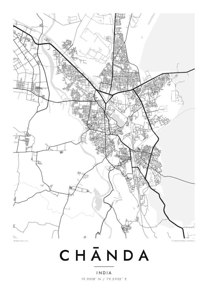
Chānda, officially Chandrapur, grew up inside a long stone wall built under the Gond kings who ruled this part of eastern Maharashtra. On a map the old town still shows that outline: a rough loop of roads following the line of the ramparts, with gateways where traffic squeezes through and denser lanes packed inside. Newer districts spread outward in looser blocks on every side.
Water frames the town to the west and east. The Erai River runs down its western edge and the smaller Zarpat stream passes the eastern side, so the built-up area sits on the higher ground between two thin blue lines. Rail tracks and highways cut across the plain, and broad industrial sites mark the power station and coal workings that made the district's name.
A Chānda map poster reduces all of this to line and space: the curve of the old wall, the river channels, the rail spur and the grid of the newer colonies. Beyond the frame lies the teak forest of Tadoba-Andhari Tiger Reserve, one of Maharashtra's best-known wildlife areas, which gives the town a reputation that reaches well past its coal and cement.
The historic wall and its gates still shape the street pattern, leaving a clear ring of older, tighter lanes at the centre of the modern city.
The Erai runs along the western side of town, a narrow river line that gives the map a firm boundary and a sense of direction.
Large rectangular footprints of the thermal power station and mining areas sit on the fringes, contrasting sharply with the fine grain of the old town.
Özüňiziňki ediň
Sene, at ýa-da öz setiriňizi goşuň, stili, ölçegi ýa-da ugry üýtgediň.
Mugt deslapky görnüş pes durulykda we suw belgili. Çaplar we HD faýllar suw belgisiz, 300 DPI, 7,200 × 10,800 px çenli işlenip taýýarlanýar.
Näme üçin Chānda
People from Chandrapur often carry the old town in their heads as a set of gates and turns. A framed map puts that memory on the wall, whether it marks a family home, a first posting, or a stop on the way to the tiger reserve.
The title, subtitle and coordinates line can be changed to a name, a date or a phrase. Choose Classic black & white, Noir, Paper, Blueprint or Sand, download the HD files for $9, or order a matte print with an optional wooden frame.
Chānda posterini sargyt ediň| Çap ölçegi | Çözgüt | Faýllar |
|---|---|---|
| 30 × 40 cm (11.8 × 15.7″) | 3,543 × 4,724 px | PNG · PDF |
| 29.7 × 42 cm (A3, 11.7 × 16.5″) | 3,508 × 4,961 px | PNG · PDF |
| 42 × 59.4 cm (A2, 16.5 × 23.4″) | 4,961 × 7,016 px | PNG · PDF |
| 45.7 × 61 cm (18 × 24″) | 5,400 × 7,200 px | PNG · PDF |
| 50 × 70 cm (19.7 × 27.6″) | 5,906 × 8,268 px | PNG · PDF |
| 61 × 91.4 cm (24 × 36″) | 7,200 × 10,800 px | PNG · PDF |
Deňeşdirmek üçin: mugt nusga 900 px giňlikde, suw belgili we ekranlar üçin niýetlenen. HD faýllaryň çözgüdi her tarapa 8 esse çenli ýokary we doly plakat ölçeginde arassa çap edilýär.
Sahypanyň ýokarsyndan stili saýlaň, soňra Çap edilen Poster — ölçegini we isleseňiz çarçuwasyny — ýa-da Sanly HD Faýllary saýlaň. Töleg bir ädimde amala aşyrylýar, tölegiňiz geçen dessine sargyt sahypaňyz täzelenýär.
Ol ýokary hilli 200 gsm mat kagyza, alty ölçegiň birinde, 30 × 40 sm-den 24 × 36″-a çenli çap edilýär. Çap edilen posterler {printFrom}-dan başlaýar, eltip bermek bahasy girýär.
Hawa. Gara, ak, tebigy dub ýa-da garaňky agaç reňkinde tutuş agaç çarçuwany saýlaň. Ol döwülmeýän aýna bilen gelýär we asmaga taýýar. Çarçuwaly posterler {framedFrom}-dan başlaýar, eltip bermek bahasy girýär.
Eltip bermek dünýäniň ähli ýerinde mugt. Her poster 30-dan gowrak ýurtdaky çap hyzmatdaşlarymyzyň iň ýakynynda çap edilýär we adatça 3–7 iş gününde gelýär. Ýagdaýyny we yzarlamany Sargytlarym bölüminde görüp bilersiňiz.
Eltilenden soň 14 günüň dowamynda bize surat iberiň, biz ony mugt gaýtadan çap ederis ýa-da puluňyzy yzyna gaýtararys.
Hawa. Bu sahypadaky redaktorda ady, kiçi ady we koordinatlar setirini islän zadyňyza üýtgediň, soňra stil we ölçeg saýlaň. Çap edilen, çarçuwaly we sanly sargytlaryň ählisi siziň dizaýnyňyzy takyk ulanýar.
$9 üçin ähli alty ölçegde, suw belgisiz, islendik ýerde çap edip bolýan 300 DPI PNG we çap etmäge taýyn PDF faýllaryny alýarsyňyz. Entek gutarnykly karara gelmediňizmi? Ilki mugt, suw belgili deslapky görnüşi göçürip alyň.
