The Old City walls
The Ottoman walls, completed under Suleiman the Magnificent in the 1530s, enclose the Old City in an unmistakable outline. Gates such as Damascus Gate and Herod's Gate open onto the northern districts.
Minimalistik karta plakaty · Palestina territoriýasy
31.7868° N / 35.2449° E
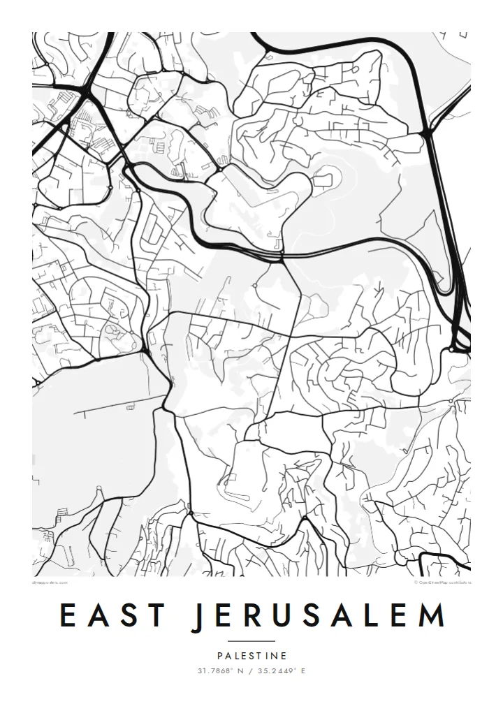
Walled Old City at the centre, the Kidron Valley and Mount of Olives to the east, neighbourhoods spreading north and south


Bir şäher, bäş keýp
Diwarda nähili görünjegini görmek üçin stile basyň. Ähli stiller bir bahadan — çap edilen, çarçuwaly ýa-da HD faýl görnüşinde.
 Hakyky pikseller · 24 × 36″ çap faýly
Çapda aýdyň
Bu hakyky çap faýlynyň 100% kesigi. Her poster — çap edilen, çarçuwaly ýa-da ýüklenen — serwerlerimizde 300 DPI, 7,200 × 10,800 piksele çenli işlenip taýýarlanýar, şonuň üçin iň kiçi köçeler hem 24 × 36″ çapda arassa görünýär.
Diwarda


Karta
From above, East Jerusalem arranges itself around the walled Old City. The walls form a clear, slightly skewed quadrilateral. Roads leave its gates and climb into the hills in every direction. To the east, the ground drops into the Kidron Valley and rises again to the Mount of Olives. Its slopes are marked by terraced cemeteries and a thin line of roads that follows the contours.
North of Damascus Gate, the street pattern becomes denser and more regular. Neighbourhoods such as Sheikh Jarrah spread along the road towards Ramallah. Further out, the map fragments into hilltop quarters separated by wadis and main roads. Because the terrain shapes almost every street, a East Jerusalem map poster reads as much like a relief study as a plan of a city.
The eastern side of the city has been contested since 1967, when Israel took control of the area. Its status remains central to Israeli–Palestinian negotiations. On paper, the lines are quieter. Gates, valleys, ridges and the long road descending towards Jericho are all shown with the same even weight. That lets the geography speak before the politics does.
The Ottoman walls, completed under Suleiman the Magnificent in the 1530s, enclose the Old City in an unmistakable outline. Gates such as Damascus Gate and Herod's Gate open onto the northern districts.
A deep, narrow valley runs north to south between the Old City and the Mount of Olives. On the map it shows as a clean gap between two dense areas of streets.
The ridge east of the Old City carries winding roads and large cemetery grounds. From above, its streets curve with the slope rather than following a grid.
Özüňiziňki ediň
Sene, at ýa-da öz setiriňizi goşuň, stili, ölçegi ýa-da ugry üýtgediň.
Mugt deslapky görnüş pes durulykda we suw belgili. Çaplar we HD faýllar suw belgisiz, 300 DPI, 7,200 × 10,800 px çenli işlenip taýýarlanýar.
Näme üçin East Jerusalem
People who have lived in, studied in or prayed in this part of Jerusalem often want a map that is honest and restrained. A black-and-white plan of streets and slopes keeps the focus on the place itself, not on the headlines.
You can set your own title and add a subtitle with a date, a family name or a line of coordinates. Then choose from five styles: Classic black & white, Noir, Paper, Blueprint or Sand. The same composition can suit a study wall or a quiet hallway.
East Jerusalem posterini sargyt ediň| Çap ölçegi | Çözgüt | Faýllar |
|---|---|---|
| 30 × 40 cm11.8 × 15.7″ | 3,543 × 4,724 px | PNG · PDF |
| 29.7 × 42 cm (A3)11.7 × 16.5″ | 3,508 × 4,961 px | PNG · PDF |
| 42 × 59.4 cm (A2)16.5 × 23.4″ | 4,961 × 7,016 px | PNG · PDF |
| 45.7 × 61 cm18 × 24″ | 5,400 × 7,200 px | PNG · PDF |
| 50 × 70 cm19.7 × 27.6″ | 5,906 × 8,268 px | PNG · PDF |
| 61 × 91.4 cm24 × 36″ | 7,200 × 10,800 px | PNG · PDF |
Deňeşdirmek üçin: mugt nusga 900 px giňlikde, suw belgili we ekranlar üçin niýetlenen. HD faýllaryň çözgüdi her tarapa 8 esse çenli ýokary we doly plakat ölçeginde arassa çap edilýär.
Sahypanyň ýokarsyndan stili saýlaň, soňra Çap edilen Poster — ölçegini we isleseňiz çarçuwasyny — ýa-da Sanly HD Faýllary saýlaň. Töleg bir ädimde amala aşyrylýar, tölegiňiz geçen dessine sargyt sahypaňyz täzelenýär.
Ol ýokary hilli 200 gsm mat kagyza, alty ölçegiň birinde, 30 × 40 sm-den 24 × 36″-a çenli çap edilýär. Çap edilen posterler $39-dan başlaýar, eltip bermek bahasy girýär.
Hawa. Gara, ak, tebigy dub ýa-da garaňky agaç reňkinde tutuş agaç çarçuwany saýlaň. Ol döwülmeýän aýna bilen gelýär we asmaga taýýar. Çarçuwaly posterler $99-dan başlaýar, eltip bermek bahasy girýär.
60+ ýurda eltip bermek mugt. Her plakat 30+ ýurtdaky çap hyzmatdaşlarymyzyň iň ýakynynda çap edilýär we adatça 3–7 iş gününde gelýär. Ýagdaýyny we yzarlamany «Meniň sargytlarym» bölüminde görüp bilersiňiz. Käbir ýurtlara 2–5 hepde gerek, entek eltip bermeýän ýurtlarymyz üçin bolsa sahypa töleg etmezden öň habar berýär.
Eltilenden soň 14 günüň dowamynda bize surat iberiň, biz ony mugt gaýtadan çap ederis ýa-da puluňyzy yzyna gaýtararys.
Hawa. Bu sahypadaky redaktorda ady, kiçi ady we koordinatlar setirini islän zadyňyza üýtgediň, soňra stil we ölçeg saýlaň. Çap edilen, çarçuwaly we sanly sargytlaryň ählisi siziň dizaýnyňyzy takyk ulanýar.
$9 üçin ähli alty ölçegde, suw belgisiz, islendik ýerde çap edip bolýan 300 DPI PNG we çap etmäge taýyn PDF faýllaryny alýarsyňyz. Entek gutarnykly karara gelmediňizmi? Ilki mugt, suw belgili deslapky görnüşi göçürip alyň.
Golaýda
