Excavated harbour
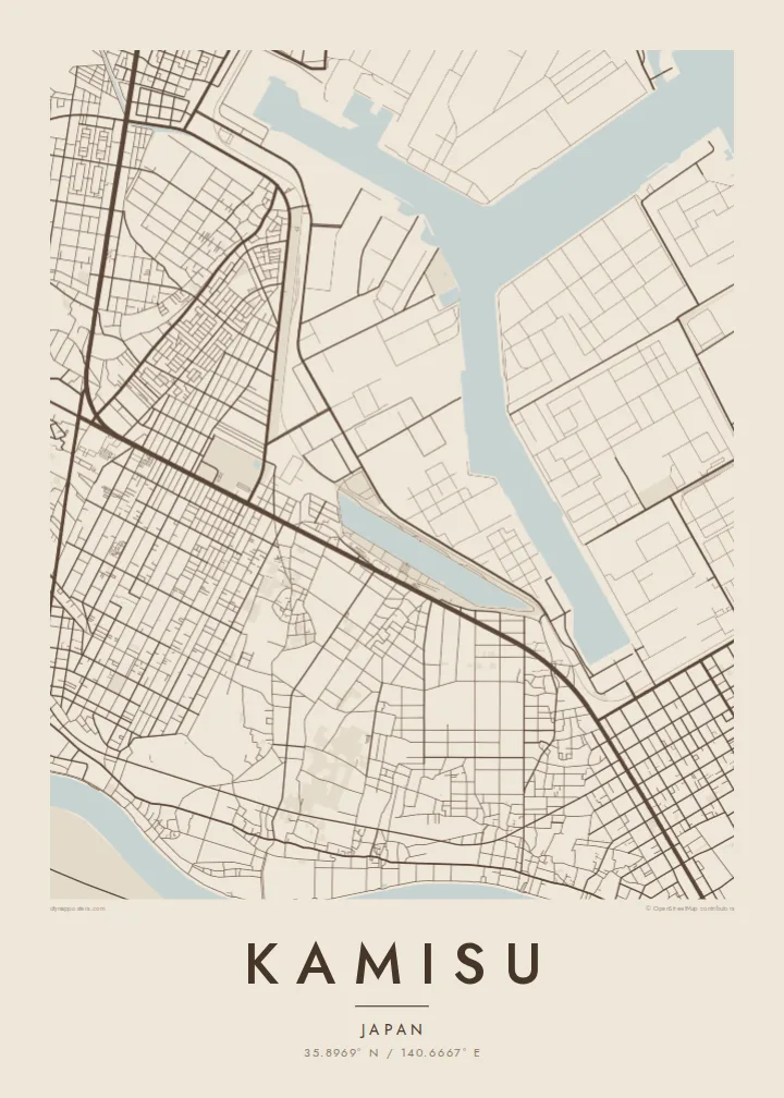
A large port basin was dug into the coast to serve heavy industry. Its straight quays and branching channels make the most striking shape on the map.
Minimalistik karta plakaty · Ýaponiýa
35.8969° N / 140.6667° E
A coastal industrial city on the Pacific shore of Ibaraki, set between a long sandy beach, a dug-out port and the lower Tone.


Bir şäher, bäş keýp
Diwarda nähili görünjegini görmek üçin stile basyň. Ähli stiller bir bahadan — çap edilen, çarçuwaly ýa-da HD faýl görnüşinde.
 Hakyky pikseller · 24 × 36″ çap faýly
Çapda aýdyň
Bu hakyky çap faýlynyň 100% kesigi. Her poster — çap edilen, çarçuwaly ýa-da ýüklenen — serwerlerimizde 300 DPI, 7,200 × 10,800 piksele çenli işlenip taýýarlanýar, şonuň üçin iň kiçi köçeler hem 24 × 36″ çapda arassa görünýär.
Diwarda


Karta
Kamisu occupies the southern part of a long, low strip of land on the eastern edge of Ibaraki. The Pacific lies on one side, and the waterways of the lower Tone River region lie inland. On a map, a straight, unbroken coastline runs along its east. Just inland, a large artificial harbour and industrial zone have been cut into the land.
This is part of the Kashima coastal industrial area, developed in the second half of the twentieth century around an excavated port. Petrochemical plants, steelworks and storage facilities occupy large, regular sites. Residential neighbourhoods, farmland and pine woods fill the remaining ground, and wind turbines stand along parts of the coast.
A Kamisu map poster shows an unusual mix: the clean line of the Pacific shore, the angular basins of the man-made port, the large blocks of industry and the smaller streets of the towns around them. It is a map shaped as much by engineering as by nature.
A large port basin was dug into the coast to serve heavy industry. Its straight quays and branching channels make the most striking shape on the map.
A long, nearly straight sandy coast runs along the eastern side. It sets a clean edge that contrasts with the complex industrial forms inland.
To the west and south, the rivers and wetlands of the lower Tone basin soften the map. They add curving lines against the rectilinear industrial zone.
Özüňiziňki ediň
Sene, at ýa-da öz setiriňizi goşuň, stili, ölçegi ýa-da ugry üýtgediň.
Mugt deslapky görnüş pes durulykda we suw belgili. Çaplar we HD faýllar suw belgisiz, 300 DPI, 7,200 × 10,800 px çenli işlenip taýýarlanýar.
Näme üçin Kamisu
For people who work in the Kashima industrial zone or grew up along this coast, Kamisu is a place of shifts, sea wind and long straight roads. Its map is bold and geometric, and it makes a strong image.
Personalise the title, subtitle and coordinates line, and choose Classic black & white, Noir, Paper, Blueprint or Sand. The $9 download includes six sizes. Prints come on matte paper with an optional wooden frame.
Kamisu posterini sargyt ediň| Çap ölçegi | Çözgüt | Faýllar |
|---|---|---|
| 30 × 40 cm (11.8 × 15.7″) | 3,543 × 4,724 px | PNG · PDF |
| 29.7 × 42 cm (A3, 11.7 × 16.5″) | 3,508 × 4,961 px | PNG · PDF |
| 42 × 59.4 cm (A2, 16.5 × 23.4″) | 4,961 × 7,016 px | PNG · PDF |
| 45.7 × 61 cm (18 × 24″) | 5,400 × 7,200 px | PNG · PDF |
| 50 × 70 cm (19.7 × 27.6″) | 5,906 × 8,268 px | PNG · PDF |
| 61 × 91.4 cm (24 × 36″) | 7,200 × 10,800 px | PNG · PDF |
Deňeşdirmek üçin: mugt nusga 900 px giňlikde, suw belgili we ekranlar üçin niýetlenen. HD faýllaryň çözgüdi her tarapa 8 esse çenli ýokary we doly plakat ölçeginde arassa çap edilýär.
Sahypanyň ýokarsyndan stili saýlaň, soňra Çap edilen Poster — ölçegini we isleseňiz çarçuwasyny — ýa-da Sanly HD Faýllary saýlaň. Töleg bir ädimde amala aşyrylýar, tölegiňiz geçen dessine sargyt sahypaňyz täzelenýär.
Ol ýokary hilli 200 gsm mat kagyza, alty ölçegiň birinde, 30 × 40 sm-den 24 × 36″-a çenli çap edilýär. Çap edilen posterler {printFrom}-dan başlaýar, eltip bermek bahasy girýär.
Hawa. Gara, ak, tebigy dub ýa-da garaňky agaç reňkinde tutuş agaç çarçuwany saýlaň. Ol döwülmeýän aýna bilen gelýär we asmaga taýýar. Çarçuwaly posterler {framedFrom}-dan başlaýar, eltip bermek bahasy girýär.
Eltip getirmek dünýäniň hemme ýerine mugt. Her plakat 30-dan gowrak ýurtdaky çap hyzmatdaşlarymyzyň iň ýakynynda çap edilýär we adatça 3–7 iş gününde gelýär. Ýagdaýyny we yzarlaýyş maglumatyny «Meniň sargytlarym» bölüminde görüp bilersiňiz. Käbir ýurtlara 2–5 hepde gerek bolýar, entek eltip bermeýän ýurtlarymyz üçin bolsa sagdyn töleginden öň sahypada habar berilýär.
Eltilenden soň 14 günüň dowamynda bize surat iberiň, biz ony mugt gaýtadan çap ederis ýa-da puluňyzy yzyna gaýtararys.
Hawa. Bu sahypadaky redaktorda ady, kiçi ady we koordinatlar setirini islän zadyňyza üýtgediň, soňra stil we ölçeg saýlaň. Çap edilen, çarçuwaly we sanly sargytlaryň ählisi siziň dizaýnyňyzy takyk ulanýar.
$9 üçin ähli alty ölçegde, suw belgisiz, islendik ýerde çap edip bolýan 300 DPI PNG we çap etmäge taýyn PDF faýllaryny alýarsyňyz. Entek gutarnykly karara gelmediňizmi? Ilki mugt, suw belgili deslapky görnüşi göçürip alyň.
Golaýda
