Bago River
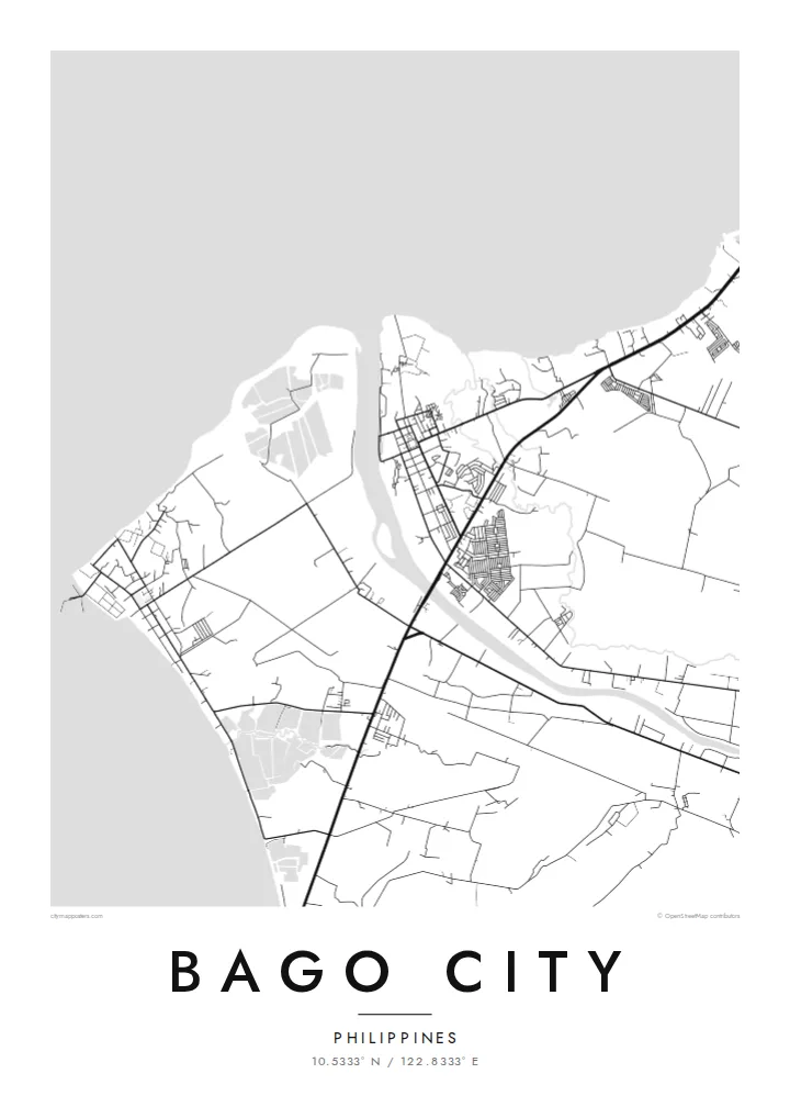
The river crosses the plain from the uplands to the coast, with the town centre close to its banks. On the map it is a clear curving line through the agricultural grid.
Pōhita mape faigofie · Philippines
10.5333° N / 122.8333° E
A sugar city on the coastal plain of Negros, stretching from the Guimaras Strait inland toward the slopes of Kanlaon.


Taone e tahi, lagona e lima
Pa'i se ata ke va'ai ai i luga o te pā. E tutusa te tau o ata uma — i lomiga, fakapipi'i i faleata, pe ko faila HD.
 Pixels mo'i · Faila lomiga 24 × 36″
Manino mo te lomiga
Ko se kupega 100% mai te faila lomiga mo'i. Poster uma — pe lomiina, fakapipi'i i faleata, pe download-ina — e fakaatagia i luga o a matou setula i te 300 DPI, e oo atu ki te 7,200 × 10,800 pixels, ina ia mautinoa e ma'ai pea auala tuai foki i luga o se lomiga 24 × 36″.
I luga o te pa


Te mape
Bago City lies on the western side of Negros Island, just south of Bacolod, on a broad plain that rises gently from the Guimaras Strait toward the mountains of the interior. From above, the compact town centre sits near the Bago River, surrounded by an immense pattern of sugarcane fields, farm roads and scattered villages that stretch inland across the city's large territory.
Like much of Negros Occidental, Bago developed around sugar, and cane fields still shape almost every part of the map. The city is the birthplace of General Juan Araneta, a leader of the 1898 revolution on Negros, and to the east its territory reaches toward Mount Kanlaon, the island's highest peak and an active volcano.
A Bago City map poster captures the scale of this landscape: the river winding toward the sea, the town at its banks, the long roads across the plantations and the rising ground in the east. In black and white, the field boundaries and roads form a precise pattern of lines, like a surveyor's drawing.
The river crosses the plain from the uplands to the coast, with the town centre close to its banks. On the map it is a clear curving line through the agricultural grid.
Large plantation fields divided by farm roads cover much of the city's land. From above they create a wide, geometric mosaic that gives the poster its character.
To the west the city reaches the Guimaras Strait, where the plain meets the sea along a low, gently curving shore. It forms a quiet edge to the composition and a counterpoint to the fields.
Fai mo koe
Fakaopoopo he aho, he igoa pe he upu a koe, hui te faiga, te lahi pe te tūlaga.
Ko te va'aiga e leai se totogi e maualalo tona resolution ma iai se fakailoga vai. E fakaatagia lomiga ma faila HD i te 300 DPI, e oo atu ki te 7,200 × 10,800 px, e aunoa ma se fakailoga vai.
Aiheā Bago City
For people from Bago City, whether they still live on Negros or work abroad, a map of the town and its fields is a way of keeping home close. It also makes a considered gift for a homecoming, a graduation or a wedding.
Add a title, subtitle and coordinates line with a barangay name or a meaningful date, and choose one of five styles: Classic black & white, Noir, Paper, Blueprint or Sand. Sand pairs naturally with the colours of the cane fields.
Oka te poster Bago City| Lahi o te lomiga | Manino | Faila |
|---|---|---|
| 30 × 40 cm11.8 × 15.7″ | 3,543 × 4,724 px | PNG · PDF |
| 29.7 × 42 cm (A3)11.7 × 16.5″ | 3,508 × 4,961 px | PNG · PDF |
| 42 × 59.4 cm (A2)16.5 × 23.4″ | 4,961 × 7,016 px | PNG · PDF |
| 45.7 × 61 cm18 × 24″ | 5,400 × 7,200 px | PNG · PDF |
| 50 × 70 cm19.7 × 27.6″ | 5,906 × 8,268 px | PNG · PDF |
| 61 × 91.4 cm24 × 36″ | 7,200 × 10,800 px | PNG · PDF |
Mo te fakatatau, ko te fakaakoakoga e hē totogi e 900 px te lautele, e ihi te fakailoga ma mo te lau komipiuta. Ko nā faila HD e oko ki te 8× te manino i itū taki tahi ma e lomia lelei i te lahi kātoa o te pōhita.
Filifili se ata i te pito i luga o te itulau, ona filifili lea o te Poster Lomiina — se lapoa ma, ka manako ai koe, se faleata — pe ko Faila HD Fakaonaonaina. E tasi te laasaga o te ōkaina, ma ka fakafou loa lau itulau ōkaina pe a mae'a te totogi.
E lomiina i luga o se pepa matte kaliki maualuga e 200 gsm, i se tasi o ni lapoa e ono, mai le 30 × 40 cm ki te 24 × 36″. E kamata te tau o poster lomiina mai le $39, aofia ai te uta.
Ioe. Filifili se faleata lakau malō i te lanu uli, tea, oki masani pe lakau pouli. E aumai fakatasi mo se tioata e le gagamu ma ua sauni ke tautau. E kamata te tau o poster fakapipi'i i se faleata mai le $99, aofia ai te uta.
E tuku uma te uta ki fenua e 60+. Ko te pepa takitasi e lomi e te tasi o a matou paaga lomi i fenua e 30+, ka tae mai i aso galue e 3–7. E mafai ke e maimoa ki te tulaga mo te tulitaki i lalo o Taku Fakatonuga. E lauiti nei fenua e 2–5 wiki, ka ko nei fenua e le o tuku atu ai, e fakamatala atu e te weepisi i mua o te totogi.
Auina mai se ata pikitia i loto o te 14 aso mai te taimi na oo mai ai, ka toe lomiina e matou e leai se totogi pe toe totogi atu lau tupe.
Ioe. I te mea fakasa'o i luga o lenei itulau, sui te ulutala, te ulutala lalo ma te laina fakamaoniga tulaga ki so se mea e manako ai koe, ona filifili lea o se ata ma se lapoa. Okaina lomiina, fakapipi'i i faleata, ma fakaonaonaina e fakaaogā uma i tau ata tonu.
Mo le $9 e maua e koe ni faila PNG 300 DPI ma PDF sauni-mo-lomiga i lapoa e ono uma, e aunoa ma se fakailoga vai, ke lomiina i so se mea. E le'i mautinoa? Download muamua se va'aiga fakailoga vai e leai se totogi.
Latalata
