Euripus Strait
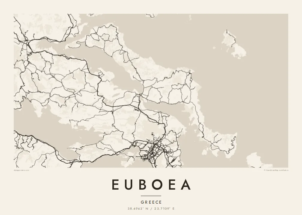
At Chalkida the channel between the island and the mainland narrows to a few dozen metres, and two bridges cross it. This tiny gap in the coastline defines the whole map.
Pōhita mape faigofie · Greece
38.4943° N / 23.7109° E
A long, narrow island lying parallel to the Greek mainland, joined to it by bridges across a strait only metres wide




Taone e tahi, lagona e lima
Pa'i se ata ke va'ai ai i luga o te pā. E tutusa te tau o ata uma — i lomiga, fakapipi'i i faleata, pe ko faila HD.
 Pixels mo'i · Faila lomiga 24 × 36″
Manino mo te lomiga
Ko se kupega 100% mai te faila lomiga mo'i. Poster uma — pe lomiina, fakapipi'i i faleata, pe download-ina — e fakaatagia i luga o a matou setula i te 300 DPI, e oo atu ki te 7,200 × 10,800 pixels, ina ia mautinoa e ma'ai pea auala tuai foki i luga o se lomiga 24 × 36″.
I luga o te pa


Te mape
Euboea is the second-largest island in Greece after Crete. It stretches for well over a hundred kilometres along the mainland coast northeast of Athens. On a map it is long, narrow and mountainous, and its axis mirrors the shape of the coast opposite. The North and South Euboean Gulfs lie between the two shores and almost close up at Chalkida, near the island's midpoint.
Chalkida, the largest town, sits at the narrowest point of the strait, the Euripus, where two bridges link the island to the mainland. The currents in the channel are well known: they change direction several times a day and have puzzled writers since ancient times. The town's streets fan out from the waterfront, and the mainland shore is only a short distance away.
The north of the island has long been known for its pine forests. The centre rises to the high peak of Dirfys, and the south narrows into a dry, rugged peninsula that ends near Karystos. Villages and small ports line both coasts, linked by roads that wind through the mountains. A Euboea map poster shows an island that feels almost part of the mainland, divided from it by a thread of sea.
At Chalkida the channel between the island and the mainland narrows to a few dozen metres, and two bridges cross it. This tiny gap in the coastline defines the whole map.
The island's highest mountain rises in central Euboea and gathers the contour lines tightly. Small roads climb to villages on its slopes and drop down to the east coast.
South of its midpoint, Euboea narrows into a long, mountainous arm that reaches toward Andros. It ends in a coast of small bays around Karystos.
Fai mo koe
Fakaopoopo he aho, he igoa pe he upu a koe, hui te faiga, te lahi pe te tūlaga.
Ko te va'aiga e leai se totogi e maualalo tona resolution ma iai se fakailoga vai. E fakaatagia lomiga ma faila HD i te 300 DPI, e oo atu ki te 7,200 × 10,800 px, e aunoa ma se fakailoga vai.
Aiheā Euboea
For many Athenians, Euboea is a place of summer homes and family villages, and it is a quieter alternative to the better-known islands. Its long profile and the fine thread of the Euripus make it a striking shape on the wall.
You can write your own title and subtitle, perhaps naming a village or a year, and adjust the coordinates line. Choose from Classic black and white, Noir, Paper, Blueprint and Sand, then order a printed poster or download the HD files for $9.
Oka te poster Euboea| Lahi o te lomiga | Manino | Faila |
|---|---|---|
| 30 × 40 cm (11.8 × 15.7″) | 3,543 × 4,724 px | PNG · PDF |
| 29.7 × 42 cm (A3, 11.7 × 16.5″) | 3,508 × 4,961 px | PNG · PDF |
| 42 × 59.4 cm (A2, 16.5 × 23.4″) | 4,961 × 7,016 px | PNG · PDF |
| 45.7 × 61 cm (18 × 24″) | 5,400 × 7,200 px | PNG · PDF |
| 50 × 70 cm (19.7 × 27.6″) | 5,906 × 8,268 px | PNG · PDF |
| 61 × 91.4 cm (24 × 36″) | 7,200 × 10,800 px | PNG · PDF |
Mo te fakatatau, ko te fakaakoakoga e hē totogi e 900 px te lautele, e ihi te fakailoga ma mo te lau komipiuta. Ko nā faila HD e oko ki te 8× te manino i itū taki tahi ma e lomia lelei i te lahi kātoa o te pōhita.
Filifili se ata i te pito i luga o te itulau, ona filifili lea o te Poster Lomiina — se lapoa ma, ka manako ai koe, se faleata — pe ko Faila HD Fakaonaonaina. E tasi te laasaga o te ōkaina, ma ka fakafou loa lau itulau ōkaina pe a mae'a te totogi.
E lomiina i luga o se pepa matte kaliki maualuga e 200 gsm, i se tasi o ni lapoa e ono, mai le 30 × 40 cm ki te 24 × 36″. E kamata te tau o poster lomiina mai le $39, aofia ai te uta.
Ioe. Filifili se faleata lakau malō i te lanu uli, tea, oki masani pe lakau pouli. E aumai fakatasi mo se tioata e le gagamu ma ua sauni ke tautau. E kamata te tau o poster fakapipi'i i se faleata mai le $99, aofia ai te uta.
E leai se totogi o te ave i te lalolagi katoa. Ko te pepa ata taki tasi e lomi e te hoa lomi e latalata mai ki a matou i atunuku e 30+, ma e masani ona aulia i aso galuega e 3–7. E mafai ke e mulimuli i te tulaga ma te ala o tau poloaiga i lalo o Aku Poloaiga. E nai atunuku e 2–5 vaiaso te umi, ma i te mea e le i ave ai matou, e fakailoa atu e te initeneti a e le i totogi koe.
Auina mai se ata pikitia i loto o te 14 aso mai te taimi na oo mai ai, ka toe lomiina e matou e leai se totogi pe toe totogi atu lau tupe.
Ioe. I te mea fakasa'o i luga o lenei itulau, sui te ulutala, te ulutala lalo ma te laina fakamaoniga tulaga ki so se mea e manako ai koe, ona filifili lea o se ata ma se lapoa. Okaina lomiina, fakapipi'i i faleata, ma fakaonaonaina e fakaaogā uma i tau ata tonu.
Mo le $9 e maua e koe ni faila PNG 300 DPI ma PDF sauni-mo-lomiga i lapoa e ono uma, e aunoa ma se fakailoga vai, ke lomiina i so se mea. E le'i mautinoa? Download muamua se va'aiga fakailoga vai e leai se totogi.
