Curving street plan
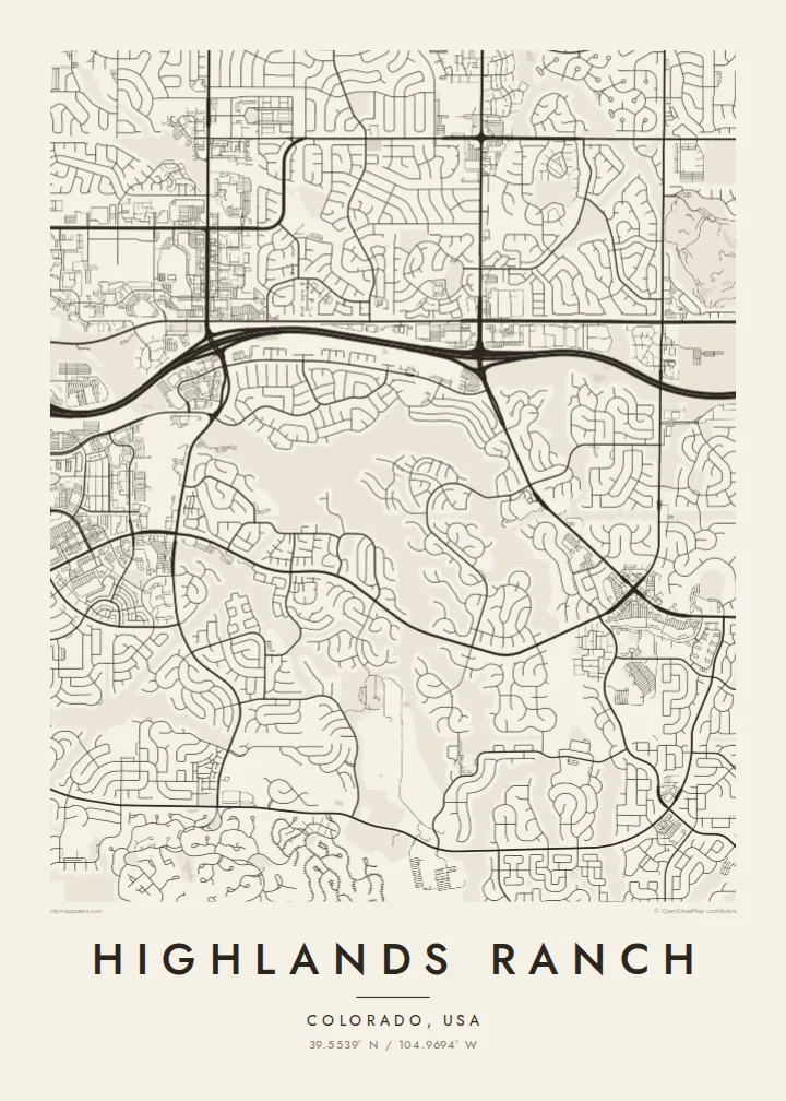
Few straight lines appear anywhere in the residential areas. Loops, crescents and cul-de-sacs follow the rolling ground, creating a flowing pattern that reads almost like a drawing.
Pōhita mape faigofie · United States
39.5539° N / 104.9694° W
A master-planned Colorado suburb of curving streets, cul-de-sacs, parks and trails on rolling ground south of Denver.




Taone e tahi, lagona e lima
Pa'i se ata ke va'ai ai i luga o te pā. E tutusa te tau o ata uma — i lomiga, fakapipi'i i faleata, pe ko faila HD.
 Pixels mo'i · Faila lomiga 24 × 36″
Manino mo te lomiga
Ko se kupega 100% mai te faila lomiga mo'i. Poster uma — pe lomiina, fakapipi'i i faleata, pe download-ina — e fakaatagia i luga o a matou setula i te 300 DPI, e oo atu ki te 7,200 × 10,800 pixels, ina ia mautinoa e ma'ai pea auala tuai foki i luga o se lomiga 24 × 36″.
I luga o te pa


Te mape
Highlands Ranch lies in Douglas County, south of Denver, and is one of the largest master-planned communities in the United States. Development began in the early 1980s on former ranch land. Its map looks nothing like the gridded older suburbs to the north: streets curve, loop and branch into cul-de-sacs across rolling ground.
Highlands Ranch is unincorporated and organised into neighbourhoods separated by greenbelts, trails and parks. A large open backcountry area to the south keeps the edge of development sharply defined, and C-470 runs along the northern side as the main boundary road. The historic Highlands Ranch Mansion survives from the ranch era.
A Highlands Ranch map poster is a study in planned curves. Main roads sweep through the landscape, residential loops cluster around them like leaves on a branch, and green corridors thread between neighbourhoods. The result is one of the most graphic suburban maps in Colorado, and it looks especially striking in the Blueprint or Noir styles.
Few straight lines appear anywhere in the residential areas. Loops, crescents and cul-de-sacs follow the rolling ground, creating a flowing pattern that reads almost like a drawing.
South of the neighbourhoods, a large protected area of open land leaves the map almost empty. This sharp boundary between development and wild ground is one of its defining features.
The highway runs along the northern side of the community as a strong, continuous line. It separates Highlands Ranch from the suburbs toward Denver and anchors the composition.
Fai mo koe
Fakaopoopo he aho, he igoa pe he upu a koe, hui te faiga, te lahi pe te tūlaga.
Ko te va'aiga e leai se totogi e maualalo tona resolution ma iai se fakailoga vai. E fakaatagia lomiga ma faila HD i te 300 DPI, e oo atu ki te 7,200 × 10,800 px, e aunoa ma se fakailoga vai.
Aiheā Highlands Ranch
Highlands Ranch is where many Colorado families put down roots, and each neighbourhood has its own shape on the map. A poster lets you point to the exact loop where you live, the trail you walk and the park where the children played.
Add a title, a subtitle with the year you moved in, and the coordinates line, then choose from five styles. Preview it free at 900 px. Buy the $9 HD files in six sizes, including 18×24″ and 24×36″, or order a printed poster with a wooden frame.
Oka te poster Highlands Ranch| Lahi o te lomiga | Manino | Faila |
|---|---|---|
| 30 × 40 cm11.8 × 15.7″ | 3,543 × 4,724 px | PNG · PDF |
| 29.7 × 42 cm (A3)11.7 × 16.5″ | 3,508 × 4,961 px | PNG · PDF |
| 42 × 59.4 cm (A2)16.5 × 23.4″ | 4,961 × 7,016 px | PNG · PDF |
| 45.7 × 61 cm18 × 24″ | 5,400 × 7,200 px | PNG · PDF |
| 50 × 70 cm19.7 × 27.6″ | 5,906 × 8,268 px | PNG · PDF |
| 61 × 91.4 cm24 × 36″ | 7,200 × 10,800 px | PNG · PDF |
Mo te fakatatau, ko te fakaakoakoga e hē totogi e 900 px te lautele, e ihi te fakailoga ma mo te lau komipiuta. Ko nā faila HD e oko ki te 8× te manino i itū taki tahi ma e lomia lelei i te lahi kātoa o te pōhita.
Filifili se ata i te pito i luga o te itulau, ona filifili lea o te Poster Lomiina — se lapoa ma, ka manako ai koe, se faleata — pe ko Faila HD Fakaonaonaina. E tasi te laasaga o te ōkaina, ma ka fakafou loa lau itulau ōkaina pe a mae'a te totogi.
E lomiina i luga o se pepa matte kaliki maualuga e 200 gsm, i se tasi o ni lapoa e ono, mai le 30 × 40 cm ki te 24 × 36″. E kamata te tau o poster lomiina mai le $39, aofia ai te uta.
Ioe. Filifili se faleata lakau malō i te lanu uli, tea, oki masani pe lakau pouli. E aumai fakatasi mo se tioata e le gagamu ma ua sauni ke tautau. E kamata te tau o poster fakapipi'i i se faleata mai le $99, aofia ai te uta.
E tuku uma te uta ki fenua e 60+. Ko te pepa takitasi e lomi e te tasi o a matou paaga lomi i fenua e 30+, ka tae mai i aso galue e 3–7. E mafai ke e maimoa ki te tulaga mo te tulitaki i lalo o Taku Fakatonuga. E lauiti nei fenua e 2–5 wiki, ka ko nei fenua e le o tuku atu ai, e fakamatala atu e te weepisi i mua o te totogi.
Auina mai se ata pikitia i loto o te 14 aso mai te taimi na oo mai ai, ka toe lomiina e matou e leai se totogi pe toe totogi atu lau tupe.
Ioe. I te mea fakasa'o i luga o lenei itulau, sui te ulutala, te ulutala lalo ma te laina fakamaoniga tulaga ki so se mea e manako ai koe, ona filifili lea o se ata ma se lapoa. Okaina lomiina, fakapipi'i i faleata, ma fakaonaonaina e fakaaogā uma i tau ata tonu.
Mo le $9 e maua e koe ni faila PNG 300 DPI ma PDF sauni-mo-lomiga i lapoa e ono uma, e aunoa ma se fakailoga vai, ke lomiina i so se mea. E le'i mautinoa? Download muamua se va'aiga fakailoga vai e leai se totogi.
Latalata
