Central crossroads
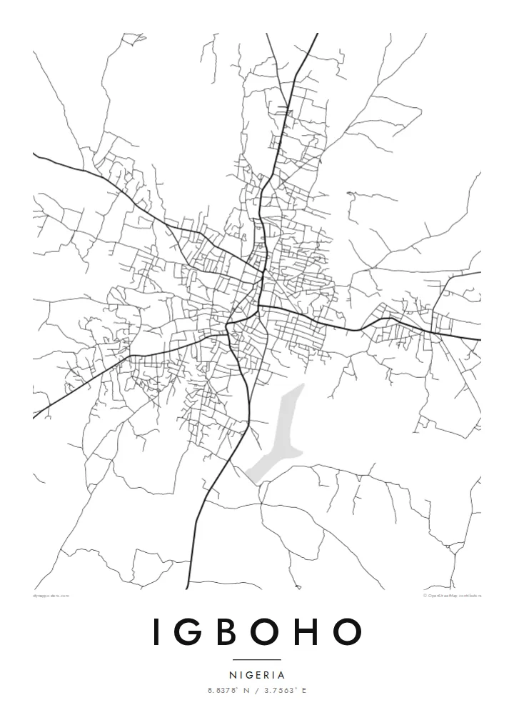
The main roads into town converge near the older core. This junction is the visual anchor of the map, and the rest of Igboho grows out from it in every direction.
Pōhita mape faigofie · Nigeria
8.8378° N / 3.7563° E
A savanna town of red-earth roads and scattered compounds, its streets radiating loosely across the open Oke-Ogun plains.


Taone e tahi, lagona e lima
Pa'i se ata ke va'ai ai i luga o te pā. E tutusa te tau o ata uma — i lomiga, fakapipi'i i faleata, pe ko faila HD.
 Pixels mo'i · Faila lomiga 24 × 36″
Manino mo te lomiga
Ko se kupega 100% mai te faila lomiga mo'i. Poster uma — pe lomiina, fakapipi'i i faleata, pe download-ina — e fakaatagia i luga o a matou setula i te 300 DPI, e oo atu ki te 7,200 × 10,800 pixels, ina ia mautinoa e ma'ai pea auala tuai foki i luga o se lomiga 24 × 36″.
I luga o te pa


Te mape
Igboho is in the Oke-Ogun area of northern Oyo State. Here the forest thins into open savanna, and the towns sit far apart along long, straight roads. From above, the town is a loose, organic spread rather than a planned grid. Main roads meet near the old centre, and around them clusters of compounds and smaller lanes fan out, gradually giving way to farmland and bush.
The town has a firm place in Yoruba history. When the Oyo kingdom was driven from its capital, Oyo-Ile, Igboho became the seat of the Alaafins for a period, and several of them are remembered as having been buried there. Today it is the headquarters of Oorelope Local Government Area, and it is a market and farming centre for the surrounding countryside.
An Igboho map poster shows a town that has grown outward from its crossroads. Seen from above, the roads cut clean diagonals across the plain, and the small streets between them form an irregular, hand-drawn texture. With so few large rivers or hills in the frame, the pattern of settlement itself becomes the subject, rendered in fine lines on open space.
The main roads into town converge near the older core. This junction is the visual anchor of the map, and the rest of Igboho grows out from it in every direction.
Between the main roads, short lanes and paths link family compounds in an irregular weave. It is a dense, organic texture that contrasts with the straight regional highways.
Beyond the built-up area the map opens into farmland and savanna. The surrounding space gives the town clear edges and a strong silhouette on the page.
Fai mo koe
Fakaopoopo he aho, he igoa pe he upu a koe, hui te faiga, te lahi pe te tūlaga.
Ko te va'aiga e leai se totogi e maualalo tona resolution ma iai se fakailoga vai. E fakaatagia lomiga ma faila HD i te 300 DPI, e oo atu ki te 7,200 × 10,800 px, e aunoa ma se fakailoga vai.
Aiheā Igboho
For people from Igboho, and for its many families living elsewhere in Nigeria and abroad, a map of the town is a direct link to home, to the compound, the market and the roads that lead back to them.
Personalise the title, subtitle and coordinates line with a family name, a quarter or a meaningful date, and pick one of five styles: Classic black and white, Noir, Paper, Blueprint or Sand. Sand suits the warm savanna setting.
Oka te poster Igboho| Lahi o te lomiga | Manino | Faila |
|---|---|---|
| 30 × 40 cm (11.8 × 15.7″) | 3,543 × 4,724 px | PNG · PDF |
| 29.7 × 42 cm (A3, 11.7 × 16.5″) | 3,508 × 4,961 px | PNG · PDF |
| 42 × 59.4 cm (A2, 16.5 × 23.4″) | 4,961 × 7,016 px | PNG · PDF |
| 45.7 × 61 cm (18 × 24″) | 5,400 × 7,200 px | PNG · PDF |
| 50 × 70 cm (19.7 × 27.6″) | 5,906 × 8,268 px | PNG · PDF |
| 61 × 91.4 cm (24 × 36″) | 7,200 × 10,800 px | PNG · PDF |
Mo te fakatatau, ko te fakaakoakoga e hē totogi e 900 px te lautele, e ihi te fakailoga ma mo te lau komipiuta. Ko nā faila HD e oko ki te 8× te manino i itū taki tahi ma e lomia lelei i te lahi kātoa o te pōhita.
Filifili se ata i te pito i luga o te itulau, ona filifili lea o te Poster Lomiina — se lapoa ma, ka manako ai koe, se faleata — pe ko Faila HD Fakaonaonaina. E tasi te laasaga o te ōkaina, ma ka fakafou loa lau itulau ōkaina pe a mae'a te totogi.
E lomiina i luga o se pepa matte kaliki maualuga e 200 gsm, i se tasi o ni lapoa e ono, mai le 30 × 40 cm ki te 24 × 36″. E kamata te tau o poster lomiina mai le {printFrom}, aofia ai te uta.
Ioe. Filifili se faleata lakau malō i te lanu uli, tea, oki masani pe lakau pouli. E aumai fakatasi mo se tioata e le gagamu ma ua sauni ke tautau. E kamata te tau o poster fakapipi'i i se faleata mai le {framedFrom}, aofia ai te uta.
E leai se totogi o te ave i te lalolagi katoa. Ko te pepa ata taki tasi e lomi e te hoa lomi e latalata mai ki a matou i atunuku e 30+, ma e masani ona aulia i aso galuega e 3–7. E mafai ke e mulimuli i te tulaga ma te ala o tau poloaiga i lalo o Aku Poloaiga. E nai atunuku e 2–5 vaiaso te umi, ma i te mea e le i ave ai matou, e fakailoa atu e te initeneti a e le i totogi koe.
Auina mai se ata pikitia i loto o te 14 aso mai te taimi na oo mai ai, ka toe lomiina e matou e leai se totogi pe toe totogi atu lau tupe.
Ioe. I te mea fakasa'o i luga o lenei itulau, sui te ulutala, te ulutala lalo ma te laina fakamaoniga tulaga ki so se mea e manako ai koe, ona filifili lea o se ata ma se lapoa. Okaina lomiina, fakapipi'i i faleata, ma fakaonaonaina e fakaaogā uma i tau ata tonu.
Mo le $9 e maua e koe ni faila PNG 300 DPI ma PDF sauni-mo-lomiga i lapoa e ono uma, e aunoa ma se fakailoga vai, ke lomiina i so se mea. E le'i mautinoa? Download muamua se va'aiga fakailoga vai e leai se totogi.
Latalata
